Shire of Narembeen
The Shire of Narembeen is a local government area in the eastern Wheatbelt region of Western Australia, about 300 kilometres (186 mi) east of the state capital, Perth, and between the shires of Merredin to the north, and Kondinin to the south. The Shire has a land area of 3,833 square kilometres (1,480 sq mi) and its seat of government is the town of Narembeen.
| Shire of Narembeen Western Australia | |||||||||||||||
|---|---|---|---|---|---|---|---|---|---|---|---|---|---|---|---|
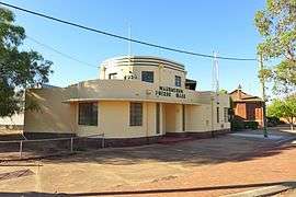 Narembeen Public Hall, 2014 | |||||||||||||||
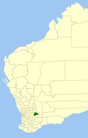 Location in Western Australia | |||||||||||||||
| Population | 809 (2016 census)[1] | ||||||||||||||
| • Density | 0.21107/km2 (0.5467/sq mi) | ||||||||||||||
| Area | 3,832.9 km2 (1,479.9 sq mi) | ||||||||||||||
| Mayor | Stephen Padfield | ||||||||||||||
| Council seat | Narembeen | ||||||||||||||
| Region | Wheatbelt | ||||||||||||||
| State electorate(s) | Central Wheatbelt | ||||||||||||||
| Federal Division(s) | Durack | ||||||||||||||
 | |||||||||||||||
| Website | Shire of Narembeen | ||||||||||||||
| |||||||||||||||
History
The Narembeen Road District was gazetted on 6 June 1924. On 1 July 1961, it became a shire following the passage of the Local Government Act 1960, which reformed all remaining road districts into shires.[2]
Towns and localities
- Narembeen
- Cramphorne
- Emu Hill
- Mount Walker
- South Kumminin
- Wogarl
References
- Australian Bureau of Statistics (27 June 2017). "Narembeen (S)". 2016 Census QuickStats. Retrieved 28 October 2019.

- "Municipality Boundary Amendments Register" (PDF). Western Australian Electoral Distribution Commission. Retrieved 11 January 2020.
This article is issued from Wikipedia. The text is licensed under Creative Commons - Attribution - Sharealike. Additional terms may apply for the media files.