City of Stirling
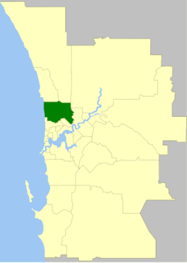
The City of Stirling is a local government area in the northern suburbs of the Western Australian capital city of Perth about 10 kilometres (6 mi) north of Perth's central business district. The City covers an area of 105.2 square kilometres (40.6 sq mi) and had a population of over 210,000 as at the 2016 Census, making it the largest local government area by population in Western Australia.
| City of Stirling Western Australia | |||||||||||||||
|---|---|---|---|---|---|---|---|---|---|---|---|---|---|---|---|
 | |||||||||||||||
| Population |
| ||||||||||||||
| • Density | 1,998.2/km2 (5,175.2/sq mi) | ||||||||||||||
| Established | 1871 | ||||||||||||||
| Area | 105.2 km2 (40.6 sq mi) | ||||||||||||||
| Mayor | Mark Irwin | ||||||||||||||
| Council seat | Stirling | ||||||||||||||
| Region | North Metropolitan Perth | ||||||||||||||
| State electorate(s) |
| ||||||||||||||
| Federal Division(s) | Curtin, Perth, Stirling | ||||||||||||||
 | |||||||||||||||
| Website | City of Stirling | ||||||||||||||
| |||||||||||||||
History
Stirling was established on 24 January 1871 as the Perth Road District under the District Roads Act 1871.[3] The district at that time included what are now the Cities of Wanneroo, Joondalup, Bayswater and Belmont.
With the passage of the Local Government Act 1960, which reformed all road districts into shires, it became the Shire of Perth. The Shire of Perth had a population of 84,000 in 1961. It was declared a city and renamed Stirling on 24 January 1971.[4][3]
Wards
The city has been divided into seven wards, each of two councillors. Each councillor serves a four-year term, and half-elections are held every two years. The mayor is elected from among the councillors.
- Balga Ward
- Coastal Ward
- Doubleview Ward
- Hamersley Ward
- Inglewood Ward
- Lawley Ward
- Osborne Ward
Suburbs
- Balcatta
- Balga
- Carine
- Churchlands
- Coolbinia
- Dianella
- Doubleview
- Glendalough
- Gwelup
- Hamersley
- Inglewood
- Innaloo
- Joondanna
- Karrinyup
- Menora
- Mirrabooka
- Mount Lawley
- Nollamara
- North Beach
- Herdsman
- Osborne Park
- Scarborough
- Stirling
- Trigg
- Tuart Hill
- Watermans Bay
- Wembley
- Wembley Downs
- Westminster
- Woodlands
- Yokine
Population
| Year | Population |
|---|---|
| 1911 | 5,066 |
| 1921 | 12,043 |
| 1933 | 19,987 |
| 1947 | 30,989 |
| 1954 | 50,090 |
| 1961 | 84,045 |
| 1966 | 114,410 |
| 1971 | 154,882 |
| 1976 | 162,313 |
| 1981 | 161,858 |
| 1986 | 164,687 |
| 1991 | 172,064 |
| 1996 | 172,819 |
| 2001 | 167,578 |
| 2006 | 176,872 |
| 2011 | 195,702 |
| 2016 | 210,208 |
- The 1996 figure includes 9,703 residents who were transferred to the City of Bayswater in 1998.
Libraries
The City of Stirling holds 6 libraries. They are the:
- Scarborough Library
- Karrinyup Library
- Dianella Library
- Inglewood Library
- Mirrabooka Library
- Osborne Library
Heritage listed places
As of 2020, 639 places are heritage-listed in the City of Stirling,[5] of which 19 are on the State Register of Heritage Places, among them the Astor Theatre and the Balcatta Senior High School.[6]
See also
References
- Australian Bureau of Statistics (27 June 2017). "Stirling (C)". 2016 Census QuickStats. Retrieved 26 November 2017.

- "3218.0 – Regional Population Growth, Australia, 2017-18". Australian Bureau of Statistics. 27 March 2019. Retrieved 31 December 2019. Estimated resident population (ERP) at 30 June 2018.
- "Municipality Boundary Amendments Register" (PDF). Western Australian Electoral Distribution Commission. Retrieved 11 January 2020.
- "Local Government Act 1960 — Order in Council (per LG 619/69)". Western Australia Government Gazette. 30 October 1970. p. 1970:3346. Nominates 24 January 1971 as effective date.
- "City of Stirling Heritage Places". inherit.stateheritage.wa.gov.au. Heritage Council of Western Australia. Retrieved 30 April 2020.
- "City of Stirling State Register of Heritage Places". inherit.stateheritage.wa.gov.au. Heritage Council of Western Australia. Retrieved 30 April 2020.