Shire of Dundas
The Shire of Dundas is a local government area in the Goldfields-Esperance region of Western Australia. The shire covers an area of 93,179 square kilometres (35,977 sq mi) and its seat of government is the town of Norseman. Its territory lies between Norseman and the border with South Australia (including much of the Eyre Highway), and is between 700 and 1,500 kilometres (430-930 mi) east of the state capital, Perth.
| Shire of Dundas Western Australia | |||||||||||||||
|---|---|---|---|---|---|---|---|---|---|---|---|---|---|---|---|
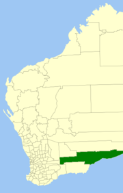 Location in Western Australia | |||||||||||||||
| Population | 772 (2016 census)[1] | ||||||||||||||
| • Density | 0.008285/km2 (0.021458/sq mi) | ||||||||||||||
| Established | 1895 | ||||||||||||||
| Area | 93,179 km2 (35,976.6 sq mi) | ||||||||||||||
| Shire President | Jacquie Best | ||||||||||||||
| Council seat | Norseman | ||||||||||||||
| Region | Goldfields-Esperance | ||||||||||||||
| State electorate(s) | Eyre | ||||||||||||||
| Federal Division(s) | O'Connor | ||||||||||||||
| Website | Shire of Dundas | ||||||||||||||
| |||||||||||||||
History
The shire was first established as the second Dundas Road District on 21 June 1929, when the Norseman Road District was abolished and replaced by a re-established Dundas board. (An earlier Dundas Road District had existed from 1895 to 1918 before amalgamating to form the Norseman district.)[2]
It was declared a shire and named the Shire of Dundas with effect from 1 July 1961 following the passage of the Local Government Act 1960, which reformed all remaining road districts into shires.[2]
Notable councillors
- Emil Nulsen, Dundas Roads Board chairman 1929–1931; later a state MP
See also
References
- Australian Bureau of Statistics (27 June 2017). "Dundas (S)". 2016 Census QuickStats. Retrieved 26 November 2017.

- "Municipality Boundary Amendments Register" (PDF). Western Australian Electoral Distribution Commission. Retrieved 11 January 2020.