Shire of Cunderdin
The Shire of Cunderdin is a local government area located in the Wheatbelt region of Western Australia, about 105 kilometres (65 mi) west of Merredin and about 155 kilometres (96 mi) east of Perth, the state capital. The Shire covers an area of 1,864 square kilometres (720 sq mi), and its seat of government is the town of Cunderdin.
| Shire of Cunderdin Western Australia | |||||||||||||||
|---|---|---|---|---|---|---|---|---|---|---|---|---|---|---|---|
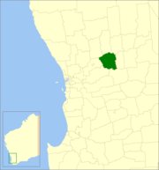 Location in Western Australia | |||||||||||||||
| Population | 1,457 (2016 ABS Census)[1] | ||||||||||||||
| • Density | 0.78157/km2 (2.0243/sq mi) | ||||||||||||||
| Gazetted | 1906 (Cunderdin townsite) | ||||||||||||||
| Postcode(s) | 6407 | ||||||||||||||
| Area | 1,864.2 km2 (719.8 sq mi) | ||||||||||||||
| Shire President | Dennis Whisson | ||||||||||||||
| Council seat | Cunderdin | ||||||||||||||
| Region | Wheatbelt | ||||||||||||||
| State electorate(s) |
| ||||||||||||||
| Federal Division(s) | Durack | ||||||||||||||
| Website | Shire of Cunderdin | ||||||||||||||
| |||||||||||||||
History
On 14 December 1894, the Meckering Road District was created, changing its name to the Cunderdin Road District on 3 November 1944. On 1 July 1961, it became a Shire following the passage of the Local Government Act 1960, which reformed all remaining road districts into shires.[2]
Wards
All wards in the shire were abolished before the 3 May 2003 election. Prior to this, it had 8 councillors representing two wards - West Ward (3 councillors) and Central Ward (5 councillors).
Cunderdin Museum
The Shire owned Cunderdin Museum is situated in the former No 3 Steam Pumping Station in Forrest Street with its tall chimney visible for miles. It has the largest local collection of memorabilia, information and photographs of the history of the Cunderdin-Meckering area, including one of the best displays of farm equipment, original steam driven water pumping machinery, railway carriages, and even includes a Tiger Moth.
The interactive Earthquake House, gives visitors a real appreciation of what the 1968 Meckering Earthquake felt like.
Open 10am to 4pm Daily (except Christmas Day and Good Friday).
The Museum is also the home of the Cunderdin Men's Shed.
Population
| Year | Population |
|---|---|
| 1911 | 2,115 |
| 1921 | 2,183 |
| 1933 | 2,745 |
| 1947 | 2,445 |
| 1954 | 2,130 |
| 1961 | 2,014 |
| 1966 | 2,114 |
| 1971 | 1,862 |
| 1976 | 1,586 |
| 1981 | 1,630 |
| 1986 | 1,484 |
| 1991 | 1,389 |
| 1996 | 1,368 |
| 2001 | 1,374 |
| 2006 | 1,250 |
References
- http://www.censusdata.abs.gov.au/census_services/getproduct/census/2016/quickstat/LGA52450?opendocument
- WA Electoral Commission, Municipality Boundary Amendments Register (release 3.0), 31 July 2007.