National Register of Historic Places listings in Lynn, Massachusetts
This is a list of the National Register of Historic Places listings in Lynn, Massachusetts.

Location of Lynn in Massachusetts
This is intended to be a complete list of the properties and districts on the National Register of Historic Places in Lynn, Massachusetts, United States. The locations of National Register properties and districts for which the latitude and longitude coordinates are included below, may be seen in an online map.[1]
Essex County, of which Lynn is a part, is the location of more than 450 properties and districts listed on the National Register. Lynn itself is the location of 28 of these properties and districts.[2]
- This National Park Service list is complete through NPS recent listings posted June 19, 2020.[3]
Current listings
| [4] | Name on the Register[2] | Image | Date listed[5] | Location | Description |
|---|---|---|---|---|---|
| 1 | Capitol Diner | 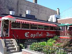 Capitol Diner |
September 22, 1999 (#99001121) |
431 Union St. 42°27′48″N 70°56′40″W |
part of the Diners of Massachusetts Multiple Property Submission (MPS) |
| 2 | Central Square Historic District |  Central Square Historic District |
December 10, 1985 (#85003335) |
Central Sq., Monroe, Union, and Willow Sts. 42°27′50″N 70°56′44″W |
|
| 3 | Diamond Historic District | 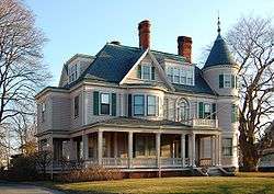 Diamond Historic District |
October 10, 1996 (#96001040) |
Roughly bounded by Broad, Lewis, Ocean Sts., Swampscott Line, Lynn Shore Dr., and Wave and Nahant Sts. 42°27′38″N 70°55′58″W |
|
| 4 | English High School | 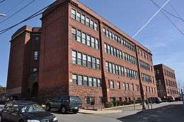 English High School |
September 11, 1986 (#86002508) |
498 Essex St. 42°27′59″N 70°56′50″W |
Listing is for the 1890s former building, not the current facilities. One of five registered structures in Lynn designed by Holman K. Wheeler. |
| 5 | Fabens Building | 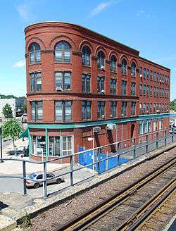 Fabens Building |
February 25, 1982 (#82001879) |
312-314 Union St. 42°27′53″N 70°56′38″W |
One of three registered buildings in Lynn designed by Henry Warren Rogers[6] |
| 6 | G.A.R. Hall and Museum |  G.A.R. Hall and Museum |
May 7, 1979 (#79000331) |
58 Andrew St. 42°27′46″N 70°56′53″W |
One of five registered structures in Lynn designed by Holman K. Wheeler |
| 7 | High Rock Tower-High Rock Cottage and Daisy Cottage |  High Rock Tower-High Rock Cottage and Daisy Cottage |
October 11, 1979 (#09000086) |
15, 17 Campbell Terr. and High Rock Park 42°28′06″N 70°56′49″W |
One of five registered structures in Lynn designed by Holman K. Wheeler |
| 8 | Charles Lovejoy House | 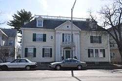 Charles Lovejoy House |
November 28, 1978 (#78000454) |
64 Broad St. 42°27′48″N 70°56′19″W |
|
| 9 | Lynn Armory | 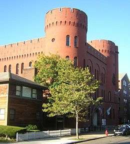 Lynn Armory |
September 7, 1979 (#79000332) |
36 S. Common St. 42°27′47″N 70°57′16″W |
One of five registered structures in Lynn designed by Holman K. Wheeler |
| 10 | Lynn Bank Block |  Lynn Bank Block |
August 26, 1982 (#82004964) |
21-29 Exchange St. 42°27′49″N 70°56′36″W |
|
| 11 | Lynn Common Historic District |  Lynn Common Historic District |
April 10, 1992 (#92000247) |
Roughly N. and S. Common St. from Market Sq. to City Hall 42°27′49″N 70°57′28″W |
|
| 12 | Lynn Masonic Hall | 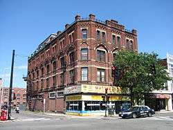 Lynn Masonic Hall |
August 21, 1979 (#79000333) |
64-68 Market St. 42°27′48″N 70°56′59″W |
|
| 13 | Lynn Memorial City Hall and Auditorium | 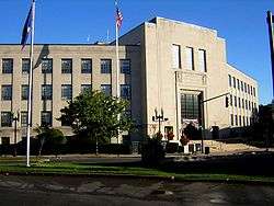 Lynn Memorial City Hall and Auditorium |
February 24, 2005 (#05000082) |
3 City Hall Square 42°27′53″N 70°57′06″W |
|
| 14 | Lynn Public Library | 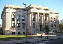 Lynn Public Library |
August 21, 1979 (#79000334) |
5 N. Common St. 42°27′52″N 70°57′15″W |
|
| 15 | Lynn Realty Company Building No. 2 |  Lynn Realty Company Building No. 2 |
March 31, 1983 (#83000579) |
672-680 Washington St. 42°27′43″N 70°56′41″W |
One of three registered buildings in Lynn designed by Henry Warren Rogers[6] |
| 16 | Lynn Woods Historic District |  Lynn Woods Historic District |
September 6, 1996 (#96000951) |
Roughly bounded by Lynnfield St., Bow Ridge, Great Woods Rd., Parkland Ave., Walnut St., Saugus Line 42°29′21″N 70°59′13″W |
|
| 17 | Mowers' Block | 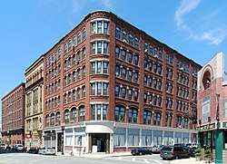 Mowers' Block |
February 25, 1982 (#82001991) |
7 Willow St. and 67-83 Blake St. 42°27′51″N 70°56′44″W |
|
| 18 | Munroe Street Historic District |  Munroe Street Historic District |
December 2, 1996 (#96000952) |
Bounded by Market, Oxford, and Washington Sts., and the MBTA commuter rail line 42°27′46″N 70°56′53″W |
|
| 19 | Nahant Beach Boulevard-Metropolitan Park System of Greater Boston | Nahant Beach Boulevard-Metropolitan Park System of Greater Boston |
August 11, 2003 (#03000747) |
Nahant Beach Boulevard 42°26′12″N 70°56′17″W |
Extends for most of its length into Nahant. Part of the Metropolitan Park System of Greater Boston MPS. |
| 20 | Lucian Newhall House | 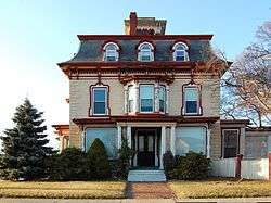 Lucian Newhall House |
July 18, 1985 (#85001576) |
281 Ocean St. 42°27′39″N 70°56′12″W |
|
| 21 | Old Lynn High School | 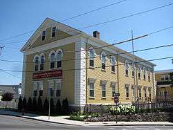 Old Lynn High School |
March 6, 2002 (#02000130) |
50 High St. 42°27′58″N 70°56′45″W |
|
| 22 | Old Post Office Building | 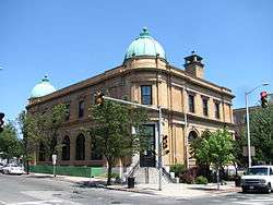 Old Post Office Building |
September 14, 1981 (#81000118) |
360 Washington St. 42°27′53″N 70°56′54″W |
|
| 23 | Pine Grove Cemetery |  Pine Grove Cemetery |
June 27, 2014 (#14000364) |
145 Boston St. 42°28′39″N 70°57′44″W |
|
| 24 | Lydia Pinkham House |  Lydia Pinkham House |
September 25, 2012 (#12000818) |
285 Western Ave. 42°28′33″N 70°57′03″W |
Pinkham's home was the mailing address for orders of her homemade herbal remedy for menstrual cramps, one of the most popular such medications of the late 19th century, as a result of her then-innovative use of her image as a marketing tool. |
| 25 | St. Stephen's Memorial Church | 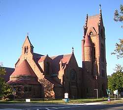 St. Stephen's Memorial Church |
September 7, 1979 (#79000335) |
74 S. Common St. 42°27′46″N 70°57′24″W |
|
| 26 | Tapley Building | 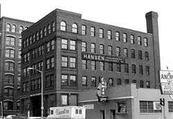 Tapley Building |
March 31, 1983 (#83000586) |
206 Broad St. 42°27′45″N 70°56′41″W |
Destroyed by fire in 1999. One of five registered structures in Lynn designed by Holman K. Wheeler. |
| 27 | Thomas P. Costin Jr. Post Office Building | 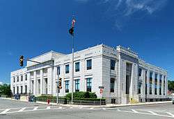 Thomas P. Costin Jr. Post Office Building |
June 20, 1986 (#86001342) |
51 Willow St. 42°27′54″N 70°56′48″W |
Renamed in 2018 as the Thomas P. Costin Jr. Post Office Building. |
| 28 | Vamp Building | 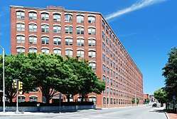 Vamp Building |
March 31, 1983 (#83000587) |
3-15 Liberty Square 42°27′45″N 70°56′50″W |
One of three registered buildings in Lynn designed by Henry Warren Rogers. Original name "Lynn Realty Company Building #4".[6] |
See also
| Wikimedia Commons has media related to National Register of Historic Places in Lynn, Massachusetts. |
References
- The latitude and longitude information provided in this table was derived originally from the National Register Information System, which has been found to be fairly accurate for about 99% of listings. Some locations in this table may have been corrected to current GPS standards.
- "National Register Information System". National Register of Historic Places. National Park Service. April 24, 2008.
- "National Register of Historic Places: Weekly List Actions". National Park Service, United States Department of the Interior. Retrieved on June 19, 2020.
- Numbers represent an ordering by significant words. Various colorings, defined here, differentiate National Historic Landmarks and historic districts from other NRHP buildings, structures, sites or objects.
- The eight-digit number below each date is the number assigned to each location in the National Register Information System database, which can be viewed by clicking the number.
- The Register of the Lynn Historical Society for the Year 1915. Lynn Historical Society. 1916. p. 31.
| Topics |  | ||||||||||||||||
|---|---|---|---|---|---|---|---|---|---|---|---|---|---|---|---|---|---|
| Lists by county | |||||||||||||||||
| Lists by city |
| ||||||||||||||||
| Other lists | |||||||||||||||||
| |||||||||||||||||
This article is issued from Wikipedia. The text is licensed under Creative Commons - Attribution - Sharealike. Additional terms may apply for the media files.