National Register of Historic Places listings in Uxbridge, Massachusetts
Uxbridge, Massachusetts has 53 sites on the National Register of Historic Places.
The locations of National Register properties and districts (at least for all showing latitude and longitude coordinates below) may be seen in an online map by clicking on "Map of all coordinates".[1]
- This National Park Service list is complete through NPS recent listings posted June 19, 2020.[2]
Uxbridge
| [3] | Name on the Register | Image | Date listed[4] | Location | Description |
|---|---|---|---|---|---|
| 1 | Benjamin Adams House | 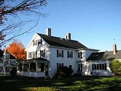 Benjamin Adams House |
October 7, 1983 (#83004101) |
85 N. Main St. 42°04′49″N 71°38′03″W |
Listed at 81 North Main. |
| 2 | E. Albee House |  E. Albee House |
October 7, 1983 (#83004102) |
217 Chapin St.[5] 42°04′07″N 71°35′42″W |
Listed on Highland St. |
| 3 | Daniel Aldrich Cottage and Sawmill |  Daniel Aldrich Cottage and Sawmill |
October 7, 1983 (#83004103) |
364 Aldrich St. 42°01′39″N 71°38′27″W |
|
| 4 | J. Aldrich House |  J. Aldrich House |
January 20, 1984 (#84002896) |
389 Aldrich St. 42°01′38″N 71°38′35″W |
|
| 5 | S. Aldrich House |  S. Aldrich House |
October 7, 1983 (#83004104) |
317 Aldrich St. 42°01′44″N 71°38′17″W |
|
| 6 | W. Aldrich House |  W. Aldrich House |
October 7, 1983 (#83004105) |
180 Henry St. 42°04′50″N 71°36′03″W |
|
| 7 | Bank Building | 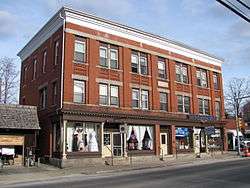 Bank Building |
October 7, 1983 (#83004106) |
40-44 S. Main St. 42°04′30″N 71°37′43″W |
Destroyed in a 2013 fire.[6] |
| 8 | Blackstone Canal Historic District |  Blackstone Canal Historic District |
February 6, 1973 (#73000328) |
Historic canal route between Providence, Rhode Island and Worcester, Massachusetts 42°08′39″N 71°40′36″W |
Initial listing included 3.5 mile stretch of canal in Northbridge and Uxbridge; expanded in 1995 to include the entire historic route of the canal from Worcester to the Rhode Island line (#95001004). |
| 9 | E. Brown House |  E. Brown House |
October 7, 1983 (#83004109) |
7 Sutton St. 42°05′N 71°39′W |
Listed at 3 Sutton Street. |
| 10 | Butler Block | 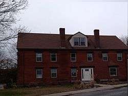 Butler Block |
October 7, 1983 (#83004110) |
166 Linwood St. 42°05′48″N 71°38′41″W |
Listed at 210 Linwood Street. |
| 11 | Charles Capron House |  Charles Capron House |
October 7, 1983 (#83004111) |
2 Capron St. 42°04′40″N 71°37′39″W |
|
| 12 | George Carpenter House |  George Carpenter House |
October 7, 1983 (#83004112) |
53 S. Main St. 42°04′25″N 71°37′42″W |
Listed at 67 South Main Street. |
| 13 | Central Woolen Mills District | 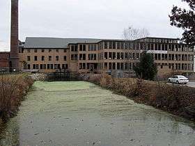 Central Woolen Mills District |
January 20, 1984 (#84002905) |
Mendon and Cross Sts. 42°04′49″N 71°37′16″W |
|
| 14 | A. Chapin House |  A. Chapin House |
October 7, 1983 (#83004113) |
36 Pleasant St. 42°04′28″N 71°37′49″W |
Listed at 26 Pleasant St. |
| 15 | A. E. Cook House |  A. E. Cook House |
October 7, 1983 (#83004115) |
176 Aldrich St. 42°01′56″N 71°37′46″W |
|
| 16 | Francis Deane Cottage |  Francis Deane Cottage |
October 7, 1983 (#83004116) |
52 N. Main St. 42°04′43″N 71°37′57″W |
Listed at 58 N. Main St. |
| 17 | Farnum Block |  Farnum Block |
October 7, 1983 (#83004117) |
2-6 N. Main St. 42°04′34″N 71°37′49″W |
Demolished.[7] |
| 18 | Coronet John Farnum House | 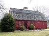 Coronet John Farnum House |
May 7, 1980 (#80001682) |
44 Mendon St. 42°04′37″N 71°37′41″W |
|
| 19 | Moses Farnum House |  Moses Farnum House |
October 7, 1983 (#83004118) |
435 Quaker Hwy (MA 146) 42°02′27″N 71°37′20″W |
|
| 20 | R. Farnum House |  R. Farnum House |
October 7, 1983 (#83004119) |
22 Oak St. 42°04′46″N 71°37′33″W |
Listed at 20 Oak Street. |
| 21 | William and Mary Farnum House |  William and Mary Farnum House |
January 20, 1984 (#84002914) |
4 Albee Rd. 42°02′42″N 71°36′30″W |
Destroyed by fire in 2013. |
| 22 | Friends Meetinghouse |  Friends Meetinghouse |
January 24, 1974 (#74000395) |
479 Quaker Hwy. 42°02′21″N 71°37′16″W |
|
| 23 | Granite Store |  Granite Store |
October 7, 1983 (#83004120) |
110 Hecla St. 42°04′28″N 71°36′47″W |
Listed at 112-116 Hecla Street. |
| 24 | S.A. Hall House | 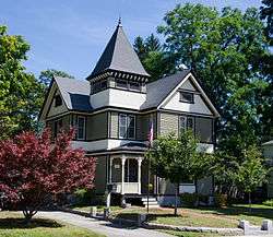 S.A. Hall House |
October 7, 1983 (#83004121) |
147 N. Main St. 42°04′54″N 71°38′16″W |
Listed at 133 North Main Street. |
| 25 | William Hayward House |  William Hayward House |
October 7, 1983 (#83004122) |
77 N. Main St. 42°04′48″N 71°38′02″W |
|
| 26 | Sylvanus Holbrook House | 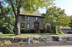 Sylvanus Holbrook House |
October 7, 1983 (#83004123) |
52 Albee Rd. 42°02′41″N 71°36′35″W |
|
| 27 | Ironstone Mill Housing and Cellar Hole |  Ironstone Mill Housing and Cellar Hole |
October 7, 1983 (#83004124) |
135 Ironstone St. 42°01′38″N 71°36′34″W |
|
| 28 | Judson-Taft House |  Judson-Taft House |
October 7, 1983 (#83004125) |
46 Pleasant St. 42°04′29″N 71°37′49″W |
Listed at 30 Pleasant St. |
| 29 | J. Kensley House | 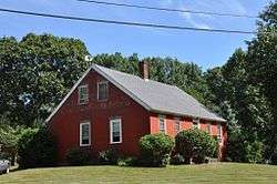 J. Kensley House |
October 7, 1983 (#83004126) |
342 Chestnut St. 42°01′41″N 71°37′32″W |
Misspelled in National Register as "J. Kensely House"[8] |
| 30 | North Uxbridge School | 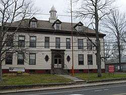 North Uxbridge School |
October 7, 1983 (#83004127) |
87 E. Hartford Ave. 42°05′31″N 71°38′21″W |
|
| 31 | Dexter Richardson House |  Dexter Richardson House |
October 7, 1983 (#83004128) |
5 South St. 42°01′29″N 71°36′52″W |
|
| 32 | Joseph Richardson House |  Joseph Richardson House |
October 7, 1983 (#83004129) |
685 Chockalog St. 42°01′47″N 71°40′21″W |
|
| 33 | Rivulet Mill Complex | 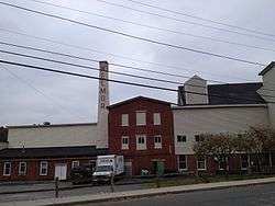 Rivulet Mill Complex |
October 7, 1983 (#83004130) |
60 Rivulet St. 42°05′15″N 71°38′40″W |
|
| 34 | Richard Sayles House |  Richard Sayles House |
October 7, 1983 (#83004131) |
80 Mendon St. 42°04′43″N 71°37′27″W |
|
| 35 | Rogerson's Village Historic District | 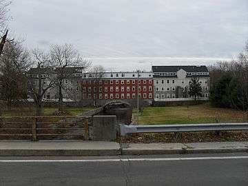 Rogerson's Village Historic District |
November 23, 1971 (#71000092) |
Northern and southern sides of Hartford Ave. 42°05′34″N 71°38′11″W |
|
| 36 | Elisha Southwick House | 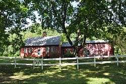 Elisha Southwick House |
October 7, 1983 (#83004132) |
255 Chockalog St. 42°02′22″N 71°38′45″W |
|
| 37 | Israel Southwick House | 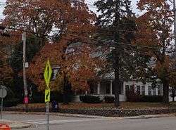 Israel Southwick House |
October 7, 1983 (#83004133) |
70 Mendon St. 42°04′42″N 71°37′33″W |
|
| 38 | Taft Brothers Block |  Taft Brothers Block |
October 7, 1983 (#83004137) |
2-8 S. Main St. 42°04′34″N 71°37′47″W |
|
| 39 | Aaron Taft House |  Aaron Taft House |
October 7, 1983 (#83004134) |
215 Hazel St. 42°04′47″N 71°39′07″W |
|
| 40 | Bazaleel Taft Jr. House and Law Office | 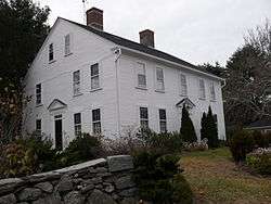 Bazaleel Taft Jr. House and Law Office |
October 7, 1983 (#83004135) |
147 S. Main St. 42°04′01″N 71°37′26″W |
|
| 41 | George Taft House |  George Taft House |
October 7, 1983 (#83004138) |
153 Richardson St. 42°03′40″N 71°38′18″W |
|
| 42 | Hon. Bazaleel Taft House | 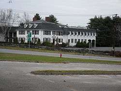 Hon. Bazaleel Taft House |
October 7, 1983 (#83004136) |
195 S. Main St. 42°04′00″N 71°36′39″W |
|
| 43 | Moses Taft House |  Moses Taft House |
October 7, 1983 (#83004139) |
50 S. Main St. 42°04′27″N 71°37′41″W |
Listed at 66 S. Main St. |
| 44 | Samuel Taft House | 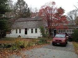 Samuel Taft House |
October 7, 1983 (#83004140) |
87 Sutton St. 42°05′28″N 71°39′21″W |
|
| 45 | Zadock Taft House |  Zadock Taft House |
October 7, 1983 (#83004148) |
115 S. Main St. 42°04′14″N 71°37′34″W |
Listed at 112 S. Main St. |
| 46 | C.R. Thomson House and Barn |  C.R. Thomson House and Barn |
October 7, 1983 (#83004142) |
795 Chockalog St. 42°01′57″N 71°40′47″W |
|
| 47 | Uxbridge Common District |  Uxbridge Common District |
January 20, 1984 (#84002920) |
Main, Court, and Douglas Sts. 42°04′38″N 71°37′53″W |
|
| 48 | Uxbridge Passenger Depot |  Uxbridge Passenger Depot |
October 7, 1983 (#83004143) |
28 S. Main St. 42°04′32″N 71°37′44″W |
|
| 49 | Uxbridge Town Hall |  Uxbridge Town Hall |
October 7, 1983 (#83004144) |
45 S. Main St. 42°04′31″N 71°37′46″W |
|
| 50 | Waucantuck Mill Complex | 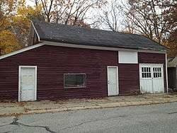 Waucantuck Mill Complex |
January 20, 1984 (#84002921) |
Mendon and Patrick Henry Sts. 42°04′57″N 71°36′31″W |
|
| 51 | Wheelockville District | 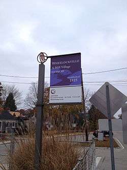 Wheelockville District |
January 20, 1984 (#84002923) |
Mendon and Henry Sts. 42°04′51″N 71°36′47″W |
|
| 52 | A. Whipple House | 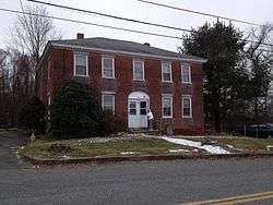 A. Whipple House |
October 7, 1983 (#83004146) |
398 Sutton St. 42°05′54″N 71°40′35″W |
|
| 53 | N. Williams House |  N. Williams House |
October 7, 1983 (#83004147) |
71 Rawson St. 42°05′24″N 71°40′38″W |
Former listing
| [3] | Name on the Register | Image | Date listed | Date removed | Location | Summary |
|---|---|---|---|---|---|---|
| 1 | Crown and Eagle Mills |  Crown and Eagle Mills |
1971 (#71001098) | 1975 | 123 Hartford St., E. |
Severely damaged by fire on October 2, 1975. Rebuilt. |
References
- The latitude and longitude information provided in this table was derived originally from the National Register Information System, which has been found to be fairly accurate for about 99% of listings. Some locations in this table may have been corrected to current GPS standards.
- "National Register of Historic Places: Weekly List Actions". National Park Service, United States Department of the Interior. Retrieved on June 19, 2020.
- Numbers represent an ordering by significant words. Various colorings, defined here, differentiate National Historic Landmarks and historic districts from other NRHP buildings, structures, sites or objects.
- The eight-digit number below each date is the number assigned to each location in the National Register Information System database, which can be viewed by clicking the number.
- "MACRIS record for E. Albee House". Commonwealth of Massachusetts. Retrieved 2013-03-06.
- http://www.telegram.com/article/20130719/NEWS/307199604/1116
- MACRIS record for Farnum Block
- "MACRIS record for J. Kensley House". Commonwealth of Massachusetts. Retrieved 2013-03-06.
External links
| Wikimedia Commons has media related to National Register of Historic Places in Uxbridge, Massachusetts. |
- City Town Info on Uxbridge - secondary source
- National Register Focus database, National Park Service.
| Topics |  | ||||||||||||||||
|---|---|---|---|---|---|---|---|---|---|---|---|---|---|---|---|---|---|
| Lists by county | |||||||||||||||||
| Lists by city |
| ||||||||||||||||
| Other lists | |||||||||||||||||
| |||||||||||||||||
This article is issued from Wikipedia. The text is licensed under Creative Commons - Attribution - Sharealike. Additional terms may apply for the media files.