National Register of Historic Places listings in Dukes County, Massachusetts
This is a list of the National Register of Historic Places listings in Dukes County, Massachusetts.
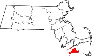
Location of Dukes County in Massachusetts
This is intended to be a complete list of the properties and districts on the National Register of Historic Places in Dukes County, Massachusetts, United States. Latitude and longitude coordinates are provided for many National Register properties and districts; these locations may be seen together in a Google map.[1]
There are 22 properties and districts listed on the National Register in the county, which include one National Historic Landmark and one National Historic Landmark District (Wesleyan Grove, which is listed twice in the register under different names).
- This National Park Service list is complete through NPS recent listings posted June 19, 2020.[2]
Current listings
| [3] | Name on the Register[4] | Image | Date listed[5] | Location | City or town | Description |
|---|---|---|---|---|---|---|
| 1 | The Arcade |  The Arcade |
August 5, 1994 (#94000813) |
31 Circuit Ave.[6] 41°27′21″N 70°33′30″W |
Oak Bluffs | Incorrectly listed on National Register at 134 Circuit Ave. |
| 2 | Barn House |  Barn House |
December 15, 2011 (#11000920) |
451 South Rd. 41°20′36″N 70°43′58″W |
Chilmark | |
| 3 | Cape Poge Light | 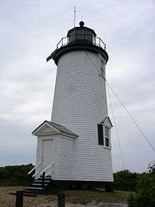 Cape Poge Light |
September 28, 1987 (#87002040) |
Chappaquiddick Island 41°25′12″N 70°27′10″W |
Edgartown | |
| 4 | East Chop Light |  East Chop Light |
June 15, 1987 (#87001480) |
Lighthouse Rd. 41°27′59″N 70°34′16″W |
Oak Bluffs | |
| 5 | Edgartown Harbor Light | 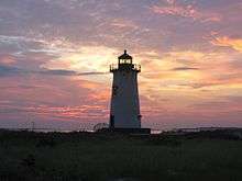 Edgartown Harbor Light |
June 15, 1987 (#87001465) |
Off N. Water St. 41°23′33″N 70°30′21″W |
Edgartown | |
| 6 | Edgartown Village Historic District | 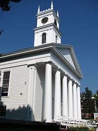 Edgartown Village Historic District |
December 9, 1983 (#83003967) |
Bounded by Water St. (North and South) and Pease's Point Way(North and South) 41°23′25″N 70°30′45″W |
Edgartown | |
| 7 | Flying Horses | 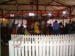 Flying Horses |
August 27, 1979 (#79000342) |
33 Oak Bluffs Ave. 41°27′26″N 70°33′28″W |
Oak Bluffs | National Historic Landmark |
| 8 | Gay Head-Aquinnah Town Center Historic District |  Gay Head-Aquinnah Town Center Historic District |
February 26, 1999 (#99000187) |
South Rd. and Church St. 41°20′31″N 70°48′50″W |
Aquinnah | Municipal and ecclesiastical buildings in Aquinnah's historic town center. |
| 9 | Gay Head-Aquinnah Light |  Gay Head-Aquinnah Light |
June 15, 1987 (#87001464) |
Lighthouse Rd. 41°21′02″N 70°50′18″W |
Aquinnah | 1856 lighthouse, near site of oldest (1799) lighthouse on Martha's Vineyard. |
| 10 | Polly Hill Arboretum Historic District | 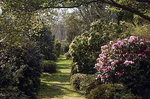 Polly Hill Arboretum Historic District |
June 15, 2015 (#15000350) |
795-833 State Rd. 41°23′51″N 70°40′50″W |
West Tisbury | |
| 11 | Martha's Vineyard Campground | 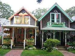 Martha's Vineyard Campground |
December 14, 1978 (#78000439) |
Roughly bounded by Cottage Park, Quequechan, Clinton, Dukes, County, Siloam, Lake, and Central Aves. 41°27′19″N 70°33′41″W |
Oak Bluffs | Duplicate of Wesleyan Grove |
| 12 | Old Mill |  Old Mill |
March 29, 1984 (#84002303) |
Edgartown-West Tisbury Rd. 41°22′55″N 70°40′20″W |
West Tisbury | |
| 13 | Ritter House | 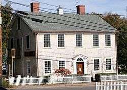 Ritter House |
December 6, 1977 (#77000169) |
Beach St. 41°27′14″N 70°36′10″W |
Vineyard Haven | |
| 14 | Tarpaulin Cove Light | 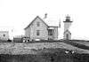 Tarpaulin Cove Light |
June 15, 1987 (#87001505) |
Naushon Island 41°28′07″N 70°45′28″W |
Gosnold | |
| 15 | Tashmoo Springs Pumping Station |  Tashmoo Springs Pumping Station |
December 3, 2008 (#08001126) |
325 W. Spring St. 41°26′54″N 70°37′19″W |
Tisbury | |
| 16 | Dr. Harrison A. Tucker Cottage | 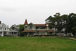 Dr. Harrison A. Tucker Cottage |
October 22, 1990 (#90000678) |
61 Ocean Ave.[7] 41°27′20″N 70°33′28″W |
Oak Bluffs | |
| 17 | Union Chapel | 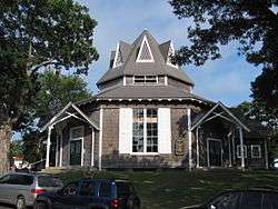 Union Chapel |
June 7, 1990 (#90000677) |
Bounded by Circuit, Kennebec, and Narragansett Aves. and Grove St. 41°27′16″N 70°33′31″W |
Oak Bluffs | |
| 18 | Edwin DeVries Vanderhoop Homestead | 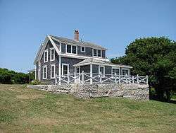 Edwin DeVries Vanderhoop Homestead |
September 6, 2006 (#06000784) |
35 South Rd. 41°20′43″N 70°50′09″W |
Aquinnah | A 19th century Wampanoag homestead, now home to the Aquinnah Cultural Center. |
| 19 | Wesleyan Grove | Wesleyan Grove |
April 5, 2005 (#05000458) |
Martha's Vineyard 41°27′23″N 70°33′34″W |
Oak Bluffs | Duplicate of Martha's Vineyard Campground |
| 20 | West Chop Club Historic District |  West Chop Club Historic District |
October 18, 2007 (#07001104) |
Iroquois Ave. 41°28′47″N 70°36′15″W |
Tisbury | |
| 21 | West Chop Light Station |  West Chop Light Station |
June 15, 1987 (#87001506) |
W. Chop Rd. 41°28′55″N 70°36′14″W |
Tisbury | |
| 22 | William Street Historic District |  William Street Historic District |
January 27, 1983 (#83000571) |
Williams St. from Wood Lawn Ave. to 24 Williams St. 41°27′25″N 70°36′24″W |
Tisbury |
See also
| Wikimedia Commons has media related to National Register of Historic Places in Dukes County, Massachusetts. |
References
- The latitude and longitude information provided in this table was derived originally from the National Register Information System, which has been found to be fairly accurate for about 99% of listings. Some locations in this table may have been corrected to current GPS standards.
- "National Register of Historic Places: Weekly List Actions". National Park Service, United States Department of the Interior. Retrieved on June 19, 2020.
- Numbers represent an ordering by significant words. Various colorings, defined here, differentiate National Historic Landmarks and historic districts from other NRHP buildings, structures, sites or objects.
- "National Register Information System". National Register of Historic Places. National Park Service. March 13, 2009.
- The eight-digit number below each date is the number assigned to each location in the National Register Information System database, which can be viewed by clicking the number.
- MACRIS entry for The Arcade
- "Weekly list of actions taken on properties: 2/25/13 through 3/01/13". National Park Service. March 8, 2013. Retrieved March 14, 2013.
| Topics |  | ||||||||||||||||
|---|---|---|---|---|---|---|---|---|---|---|---|---|---|---|---|---|---|
| Lists by county | |||||||||||||||||
| Lists by city |
| ||||||||||||||||
| Other lists | |||||||||||||||||
| |||||||||||||||||
Municipalities and communities of Dukes County, Massachusetts, United States | ||
|---|---|---|
| Towns | | |
| CDPs | ||
| Other villages | ||
| Indian reservation | ||
This article is issued from Wikipedia. The text is licensed under Creative Commons - Attribution - Sharealike. Additional terms may apply for the media files.