National Register of Historic Places listings in Concord, Massachusetts
This is a list of places on the National Register of Historic Places in Concord, Massachusetts.
- This National Park Service list is complete through NPS recent listings posted June 19, 2020.[1]
Concord
| [2] | Name on the Register[3] | Image | Date listed[4] | Location | Description |
|---|---|---|---|---|---|
| 1 | Col. James Barrett Farm |  Col. James Barrett Farm |
November 15, 1973 (#73000290) |
448 Barrett's Mill Rd. 42°28′55″N 71°22′54″W |
|
| 2 | Col. Roger Brown House |  Col. Roger Brown House |
January 27, 1983 (#83000785) |
1694 Main St. 42°27′11″N 71°24′33″W |
|
| 3 | Concord Armory | 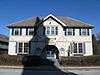 Concord Armory |
September 12, 2007 (#07000945) |
51 Walden St. 42°27′32″N 71°20′58″W |
|
| 4 | Concord Monument Square-Lexington Road Historic District |  Concord Monument Square-Lexington Road Historic District |
September 13, 1977 (#77000172) |
MA 2A 42°27′34″N 71°20′51″W |
|
| 5 | Dr. John Cuming House |  Dr. John Cuming House |
November 11, 1977 (#77000175) |
West of Concord at Barretts Mill Rd. and Reformatory Circle 42°28′02″N 71°23′47″W |
At 998 Elm Street |
| 6 | Damon Mill |  Damon Mill |
May 25, 1979 (#79000360) |
9 Pond Lane 42°27′12″N 71°24′35″W |
|
| 7 | Isaac Davis Trail |  Isaac Davis Trail |
April 11, 1972 (#72001347) |
Running east-west between the towns of Acton and Concord 42°28′48″N 71°23′57″W |
|
| 8 | Ralph Waldo Emerson House | .JPG) Ralph Waldo Emerson House |
October 15, 1966 (#66000365) |
18 Cambridge Turnpike 42°27′27″N 71°20′39″W |
National Historic Landmark |
| 9 | Jonathan Hildreth House | 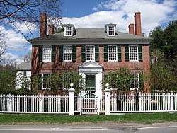 Jonathan Hildreth House |
April 3, 1991 (#91000362) |
8 Barrett's Mill Rd. 42°28′27″N 71°21′56″W |
|
| 10 | Hosmer Homestead |  Hosmer Homestead |
June 3, 1999 (#99000659) |
138 Baker Ave. 42°27′41″N 71°23′05″W |
|
| 11 | Joseph Hosmer House |  Joseph Hosmer House |
March 9, 1990 (#90000170) |
572 Main St. 42°27′26″N 71°22′13″W |
|
| 12 | Hubbard-French District | 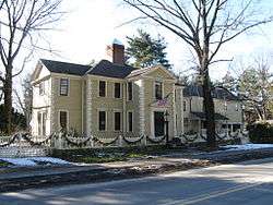 Hubbard-French District |
June 15, 2000 (#00000686) |
324 and 342 Sudbury Rd. 42°27′05″N 71°21′35″W |
|
| 13 | Minute Man National Historical Park |  Minute Man National Historical Park |
October 15, 1966 (#66000935) |
From Concord to Lexington on MA 2A 42°28′09″N 71°21′01″W |
Boundary increase (added 2002-11-29): Lexington, MA |
| 14 | Old Manse | %2C_Concord%2C_Massachusetts.JPG) Old Manse |
October 15, 1966 (#66000775) |
Monument St. 42°28′06″N 71°20′58″W |
National Historic Landmark |
| 15 | Orchard House | 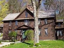 Orchard House |
October 15, 1966 (#66000781) |
Lexington Rd. 42°27′32″N 71°20′08″W |
National Historic Landmark |
| 16 | Parkman Tavern |  Parkman Tavern |
June 19, 1979 (#79000358) |
South of Concord at 20 Powder Mill Rd. 42°25′46″N 71°22′36″W |
|
| 17 | Pest House |  Pest House |
April 18, 1977 (#77000174) |
153 Fairhaven Rd. 42°26′51″N 71°21′38″W |
|
| 18 | Thomas Mott Shaw Estate |  Thomas Mott Shaw Estate |
November 20, 1987 (#87001395) |
317 Garfield Rd. 42°25′42″N 71°21′49″W |
|
| 19 | Sleepy Hollow Cemetery |  Sleepy Hollow Cemetery |
August 19, 1998 (#98000991) |
34A Bedford St. 42°27′52″N 71°20′42″W |
|
| 20 | Thoreau-Alcott House |  Thoreau-Alcott House |
July 12, 1976 (#76000247) |
255 Main St. 42°27′30″N 71°21′30″W |
|
| 21 | Union Station |  Union Station |
March 2, 1989 (#89000143) |
20 Commonwealth Ave. 42°27′24″N 71°23′40″W |
|
| 22 | Walden Pond | 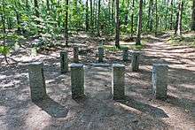 Walden Pond |
October 15, 1966 (#66000790) |
1.5 mi (2.4 km) south of Concord 42°26′20″N 71°20′20″W |
National Historic Landmark |
| 23 | The Wayside | 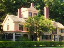 The Wayside |
July 11, 1980 (#80000356) |
455 Lexington Rd. 42°27′33″N 71°20′02″W |
National Historic Landmark |
| 24 | Wheeler-Harrington House | 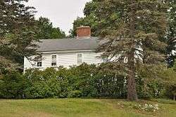 Wheeler-Harrington House |
July 23, 2013 (#13000534) |
249 Harrington Ave. 42°26′57″N 71°24′12″W |
|
| 25 | Wheeler-Minot Farmhouse |  Wheeler-Minot Farmhouse |
March 19, 2004 (#04000190) |
341 Virginia Rd. 42°28′10″N 71°18′41″W |
|
| 26 | Wheeler-Merriam House |  Wheeler-Merriam House |
November 26, 1982 (#82000493) |
477 Virginia Rd. 42°28′06″N 71°18′28″W |
|
| 27 | Wright's Tavern | .JPG) Wright's Tavern |
October 15, 1966 (#66000793) |
Lexington Road opposite the Burying Ground 42°27′36″N 71°20′57″W |
National Historic Landmark |
References
| Wikimedia Commons has media related to National Register of Historic Places in Concord, Massachusetts. |
- "National Register of Historic Places: Weekly List Actions". National Park Service, United States Department of the Interior. Retrieved on June 19, 2020.
- Numbers represent an ordering by significant words. Various colorings, defined here, differentiate National Historic Landmarks and historic districts from other NRHP buildings, structures, sites or objects.
- "National Register Information System". National Register of Historic Places. National Park Service. April 24, 2008.
- The eight-digit number below each date is the number assigned to each location in the National Register Information System database, which can be viewed by clicking the number.
| Topics |  | ||||||||||||||||
|---|---|---|---|---|---|---|---|---|---|---|---|---|---|---|---|---|---|
| Lists by county | |||||||||||||||||
| Lists by city |
| ||||||||||||||||
| Other lists | |||||||||||||||||
| |||||||||||||||||
This article is issued from Wikipedia. The text is licensed under Creative Commons - Attribution - Sharealike. Additional terms may apply for the media files.