National Register of Historic Places listings in Ipswich, Massachusetts
This is a list of the National Register of Historic Places listings in Ipswich, Massachusetts.

Location of Ipswich in Massachusetts
This is intended to be a complete list of the properties and districts on the National Register of Historic Places in Ipswich, Massachusetts, United States. The locations of National Register properties and districts for which the latitude and longitude coordinates are included below, may be seen in an online map.[1]
Essex County, of which Ipswich is a part, is the location of 461 properties and districts listed on the National Register. Ipswich itself is the location of 31 of these properties and districts.[2]
- This National Park Service list is complete through NPS recent listings posted June 26, 2020.[3]
Current listings
| [4] | Name on the Register[2] | Image | Date listed[5] | Location | Description |
|---|---|---|---|---|---|
| 1 | Bailey House |  Bailey House |
September 17, 1980 (#80000457) |
40 Market St. 42°40′43″N 70°50′24″W |
|
| 2 | Brown Stocking Mill Historic District |  Brown Stocking Mill Historic District |
August 22, 1996 (#96000924) |
24-32 Broadway Ave., 3-41 Brownville Ave., 10 Burleigh Ave., 3-5 Burleigh Pl., and 35-47 Topsfield Rd. 42°40′38″N 70°50′49″W |
|
| 3 | Brown's Manor |  Brown's Manor |
September 17, 1980 (#80000459) |
115 High St. 42°41′20″N 70°50′58″W |
|
| 4 | James Burnham House |  James Burnham House |
March 9, 1990 (#90000236) |
37 Heartbreak Rd. 42°39′53″N 70°49′49″W |
|
| 5 | Burnham-Patch House |  Burnham-Patch House |
September 17, 1980 (#80000452) |
1 Turkey Shore Rd. 42°40′35″N 70°50′01″W |
|
| 6 | Benjamin Stickney Cable Memorial Hospital |  Benjamin Stickney Cable Memorial Hospital |
May 10, 1990 (#90000683) |
Junction of MA 1A and MA 133 42°39′59″N 70°50′15″W |
|
| 7 | Caldwell Block |  Caldwell Block |
July 7, 1983 (#83003434) |
S. Main St. 42°40′46″N 70°50′17″W |
|
| 8 | Dr. John Calef House |  Dr. John Calef House |
September 17, 1980 (#80000447) |
7 Poplar St. 42°40′33″N 70°50′05″W |
|
| 9 | Castle Hill | .jpg) Castle Hill |
December 2, 1977 (#77000183) |
East of Ipswich on Argilla Rd. 42°41′09″N 70°45′53″W |
|
| 10 | Choate Bridge | 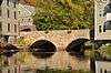 Choate Bridge |
August 21, 1972 (#72000137) |
MA 133/1A (S. Main St.) over the Ipswich River 42°40′46″N 70°50′16″W |
|
| 11 | East End Historic District | 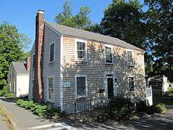 East End Historic District |
September 17, 1980 (#80000461) |
East St. 42°40′57″N 70°49′54″W |
|
| 12 | Giddings-Burnham House |  Giddings-Burnham House |
March 9, 1990 (#90000233) |
37 Argilla Rd. 42°40′25″N 70°49′54″W |
|
| 13 | Isaac Goodale House |  Isaac Goodale House |
March 9, 1990 (#90000232) |
153 Argilla Rd. 42°39′38″N 70°47′58″W |
|
| 14 | Benjamin Grant House |  Benjamin Grant House |
September 17, 1980 (#80000449) |
47 County St. 42°40′41″N 70°50′09″W |
|
| 15 | Heard-Lakeman House |  Heard-Lakeman House |
September 17, 1980 (#80000441) |
2 Turkey Shore Rd. 42°40′35″N 70°50′03″W |
|
| 16 | High Street Historic District | 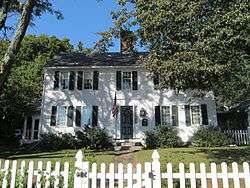 High Street Historic District |
September 17, 1980 (#80000454) |
High St. 42°41′07″N 70°50′28″W |
|
| 17 | House on Labor-in-Vain Road | 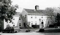 House on Labor-in-Vain Road |
March 9, 1990 (#90000234) |
Labor in Vain Rd. 42°40′40″N 70°48′22″W |
|
| 18 | Howe Barn |  Howe Barn |
March 9, 1990 (#90000230) |
421 Linebrook Rd.[6] 42°40′38″N 70°56′07″W |
Listed at 403 Linebrook Rd; this is a 17th-century barn that was converted to a house in 1948. |
| 19 | Ipswich Mills Historic District | 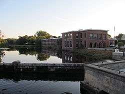 Ipswich Mills Historic District |
August 22, 1996 (#96000923) |
Roughly bounded by Union St., Boston and Maine railroad tracks, and the Ipswich River 42°40′33″N 70°50′24″W |
|
| 20 | Thomas Low House |  Thomas Low House |
March 9, 1990 (#90000237) |
36 Heartbreak Rd. 42°39′49″N 70°49′43″W |
|
| 21 | Meetinghouse Green Historic District | 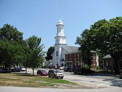 Meetinghouse Green Historic District |
September 17, 1980 (#80000464) |
N. Main St. 42°40′53″N 70°50′11″W |
|
| 22 | Merrifield House |  Merrifield House |
September 17, 1980 (#80000469) |
11 Woods Lane 42°40′39″N 70°49′51″W |
|
| 23 | Paine-Dodge House | 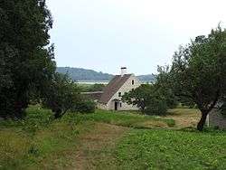 Paine-Dodge House |
March 9, 1990 (#90000231) |
49 Jeffrey's Neck Rd. 42°41′36″N 70°49′00″W |
On The Trustees of Reservations Greenwood Farm property. |
| 24 | Ross Tavern |  Ross Tavern |
March 9, 1990 (#90000235) |
52 Jeffrey's Neck Rd. 42°41′53″N 70°49′45″W |
|
| 25 | Nathaniel Rust Mansion |  Nathaniel Rust Mansion |
September 17, 1980 (#80000440) |
83 County St. 42°40′21″N 70°50′15″W |
|
| 26 | Smith House |  Smith House |
March 9, 1990 (#90000238) |
168 Argilla Rd.[7] 42°40′16″N 70°47′40″W |
Listed at 142 Argilla Rd. |
| 27 | South Green Historic District | 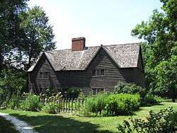 South Green Historic District |
September 17, 1980 (#80000471) |
MA 1A 42°40′32″N 70°50′13″W |
|
| 28 | Turner Hill |  Turner Hill |
November 26, 1982 (#82000483) |
315 Topsfield Rd. 42°39′48″N 70°52′59″W |
|
| 29 | Wade House | 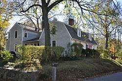 Wade House |
September 17, 1980 (#80000467) |
9 Woods Lane 42°40′35″N 70°49′53″W |
|
| 30 | John Whipple House | .jpg) John Whipple House |
October 15, 1966 (#66000791) |
53 S. Main St. 42°40′34″N 70°50′11″W |
|
| 31 | Shoreborne Wilson House |  Shoreborne Wilson House |
September 17, 1980 (#80000456) |
4 S. Main St. 42°40′44″N 70°50′14″W |
See also
| Wikimedia Commons has media related to National Register of Historic Places in Ipswich, Massachusetts. |
References
- The latitude and longitude information provided in this table was derived originally from the National Register Information System, which has been found to be fairly accurate for about 99% of listings. Some locations in this table may have been corrected to current GPS standards.
- "National Register Information System". National Register of Historic Places. National Park Service. April 24, 2008.
- "National Register of Historic Places: Weekly List Actions". National Park Service, United States Department of the Interior. Retrieved on June 26, 2020.
- Numbers represent an ordering by significant words. Various colorings, defined here, differentiate National Historic Landmarks and historic districts from other NRHP buildings, structures, sites or objects.
- The eight-digit number below each date is the number assigned to each location in the National Register Information System database, which can be viewed by clicking the number.
- MACRIS record for Abraham Howe Barn
- "1st and 2nd Period Houses" (PDF). Ipswich Historic Commission. Retrieved 2016-12-13.
| Topics |  | ||||||||||||||||
|---|---|---|---|---|---|---|---|---|---|---|---|---|---|---|---|---|---|
| Lists by county | |||||||||||||||||
| Lists by city |
| ||||||||||||||||
| Other lists | |||||||||||||||||
| |||||||||||||||||
This article is issued from Wikipedia. The text is licensed under Creative Commons - Attribution - Sharealike. Additional terms may apply for the media files.