National Register of Historic Places listings in Milton, Massachusetts
This is a list of properties and historic districts in Milton, Massachusetts, that are listed on the National Register of Historic Places.
The locations of National Register properties and districts (at least for all showing latitude and longitude coordinates below) may be seen in an online map by clicking on "Map of all coordinates".[1]
- This National Park Service list is complete through NPS recent listings posted June 19, 2020.[2]
Current listings
| [3] | Name on the Register | Image | Date listed[4] | Location | City or town | Description |
|---|---|---|---|---|---|---|
| 1 | Belcher-Rowe House | 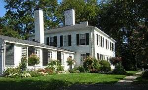 Belcher-Rowe House |
April 1, 1982 (#82002748) |
26 Governor Belcher Lane 42°15′34″N 71°02′58″W |
||
| 2 | G.H. Bent Company Factory |  G.H. Bent Company Factory |
February 10, 2000 (#00000075) |
7 Pleasant St. 42°14′42″N 71°04′10″W |
||
| 3 | Blue Hills Headquarters |  Blue Hills Headquarters |
September 25, 1980 (#80000654) |
Hillside St. 42°12′53″N 71°05′35″W |
||
| 4 | Blue Hills Reservation Parkways-Metropolitan Park System of Greater Boston | 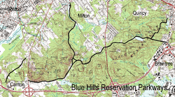 Blue Hills Reservation Parkways-Metropolitan Park System of Greater Boston |
August 11, 2003 (#03000746) |
Parts of Blue Hill Rd., Chickatawbut Rd., Hillside St., Uniquity Rd., Wampatuck Rd., and Green St. 42°13′34″N 71°04′20″W |
Extends into Quincy and into Braintree and Canton, elsewhere in Norfolk County | |
| 5 | Blue Hills Parkway | 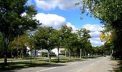 Blue Hills Parkway |
June 23, 2003 (#03000574) |
Blue Hills Parkway, Milton 42°15′21″N 71°05′38″W |
||
| 6 | Brookwood Farm | 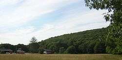 Brookwood Farm |
September 25, 1980 (#80000655) |
Off Hillside Street 42°12′34″N 71°06′41″W |
Extends into Canton, elsewhere in Norfolk County | |
| 7 | Brush Hill Historic District | 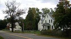 Brush Hill Historic District |
August 20, 1998 (#98001081) |
Roughly Brush Hill Rd., from Robbins St. to Bradlee Rd., and Dana Ave., Brush Hill Ln. and Fairmount Ave. 42°14′45″N 71°06′35″W |
||
| 8 | Comfort Station | 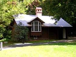 Comfort Station |
September 25, 1980 (#80000658) |
Blue Hill Ave. 42°13′09″N 71°07′06″W |
||
| 9 | Davenport Estate Historic District |  Davenport Estate Historic District |
May 17, 2018 (#100002421) |
1465, 1485, 1493 Brush Hill Rd. 42°13′25″N 71°07′07″W |
Now also known as the Wakefield Estate. | |
| 10 | Dorchester-Milton Lower Mills Industrial District |  Dorchester-Milton Lower Mills Industrial District |
April 2, 1980 (#80000675) |
Both sides of the Neponset River; also Adams, River, and Medway Sts., Millers Lane, and Eliot and Adams Sts. 42°16′16″N 71°04′08″W |
Extends into Boston in Suffolk County; Second set of addresses represents a boundary increase | |
| 11 | Eliot Memorial Bridge |  Eliot Memorial Bridge |
September 25, 1980 (#80000662) |
Milton 42°12′42″N 71°06′49″W |
||
| 12 | Eustis Estate Historic District | 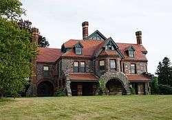 Eustis Estate Historic District |
March 22, 2016 (#16000099) |
1400, 1421, 1424, 1426 and 1452 Canton Ave. 42°13′54″N 71°06′27″W |
||
| 13 | Capt. Robert B. Forbes House | 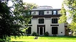 Capt. Robert B. Forbes House |
November 13, 1966 (#66000651) |
215 Adams St. 42°15′47″N 71°03′49″W |
National Historic Landmark[5] | |
| 14 | Great Blue Hill Observation Tower | 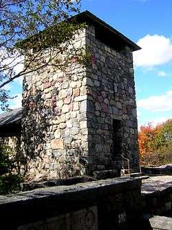 Great Blue Hill Observation Tower |
September 25, 1980 (#80000661) |
Milton 42°12′43″N 71°06′49″W |
||
| 15 | Great Blue Hill Weather Observatory | 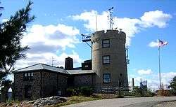 Great Blue Hill Weather Observatory |
September 25, 1980 (#80000665) |
Milton 42°12′42″N 71°06′55″W |
A National Historic Landmark as "Blue Hill Meteorological Observatory"[5] | |
| 16 | Dr. Amos Holbrook House | 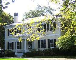 Dr. Amos Holbrook House |
February 13, 1975 (#75000289) |
203 Adams St. 42°15′55″N 71°03′59″W |
||
| 17 | Gov. Thomas Hutchinson's Ha-ha | 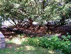 Gov. Thomas Hutchinson's Ha-ha |
February 13, 1975 (#75000290) |
100 and 122 Randolph Ave. 42°15′55″N 71°04′06″W |
||
| 18 | Massachusetts Hornfels-Braintree Slate Quarry | 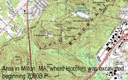 Massachusetts Hornfels-Braintree Slate Quarry |
September 25, 1980 (#80000653) |
Address Restricted |
Extends into Quincy. | |
| 19 | Metropolitan District Commission Stable | 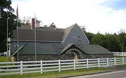 Metropolitan District Commission Stable |
September 25, 1980 (#80000663) |
Hillside St. 42°12′56″N 71°05′33″W |
||
| 20 | Milton Cemetery |  Milton Cemetery |
June 2, 2004 (#04000537) |
211 Centre St. 42°15′24″N 71°03′55″W |
||
| 21 | Milton Centre Historic District |  Milton Centre Historic District |
April 28, 1988 (#88000428) |
Canton Ave. between Reedsdale Rd. and Thacher and Highland Sts. 42°15′12″N 71°04′47″W |
||
| 22 | Milton Hill Historic District |  Milton Hill Historic District |
June 9, 1995 (#95000698) |
Roughly bounded by Adams and School Sts., Randolph and Canton Aves., and Brook Rd. 42°15′52″N 71°03′59″W |
||
| 23 | Neponset Valley Parkway, Metropolitan Park System of Greater Boston |  Neponset Valley Parkway, Metropolitan Park System of Greater Boston |
January 24, 2005 (#04001573) |
Neponset Valley Parkway 42°14′05″N 71°07′26″W |
Extends into Boston in Suffolk County | |
| 24 | Paul's Bridge | 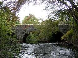 Paul's Bridge |
December 11, 1972 (#72000140) |
Neponset Valley Parkway over the Neponset River 42°14′04″N 71°07′21″W |
Extends into Boston in Suffolk County | |
| 25 | Railway Village Historic District |  Railway Village Historic District |
March 6, 2000 (#00000111) |
Roughly along Adams St., from Mechanic and Church Sts., and Washington St. 42°15′27″N 71°02′14″W |
||
| 26 | Refreshment Pavilion |  Refreshment Pavilion |
September 25, 1980 (#80000659) |
Hillside St. 42°12′31″N 71°05′52″W |
||
| 27 | Scott's Woods Historic District |  Scott's Woods Historic District |
November 5, 1992 (#92001528) |
Hillside St. between Randolph Ave. and MDC Blue Hills Reservation 42°13′27″N 71°04′50″W |
||
| 28 | Suffolk Resolves House |  Suffolk Resolves House |
July 23, 1973 (#73000308) |
1370 Canton Ave. 42°14′03″N 71°06′32″W |
||
| 29 | Truman Parkway-Metropolitan Park System of Greater Boston | 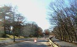 Truman Parkway-Metropolitan Park System of Greater Boston |
January 5, 2005 (#04001430) |
Truman Parkway 42°14′53″N 71°06′59″W |
Extends into Boston in Suffolk County | |
| 30 | US Post Office-Milton Main |  US Post Office-Milton Main |
May 30, 1986 (#86001213) |
499 Adams St. 42°15′30″N 71°02′34″W |
See also
References
| Wikimedia Commons has media related to National Register of Historic Places in Milton, Massachusetts. |
- The latitude and longitude information provided in this table was derived originally from the National Register Information System, which has been found to be fairly accurate for about 99% of listings. Some locations in this table may have been corrected to current GPS standards.
- "National Register of Historic Places: Weekly List Actions". National Park Service, United States Department of the Interior. Retrieved on June 19, 2020.
- Numbers represent an ordering by significant words. Various colorings, defined here, differentiate National Historic Landmarks and historic districts from other NRHP buildings, structures, sites or objects.
- The eight-digit number below each date is the number assigned to each location in the National Register Information System database, which can be viewed by clicking the number.
- "Listing of National Historic Landmarks by State: Massachusetts" (PDF). National Park Service. 2009-10-06.
| Topics |  | ||||||||||||||||
|---|---|---|---|---|---|---|---|---|---|---|---|---|---|---|---|---|---|
| Lists by county | |||||||||||||||||
| Lists by city |
| ||||||||||||||||
| Other lists | |||||||||||||||||
| |||||||||||||||||
This article is issued from Wikipedia. The text is licensed under Creative Commons - Attribution - Sharealike. Additional terms may apply for the media files.