National Register of Historic Places listings in Marlborough, Massachusetts
List of Registered Historic Places in Marlborough, Massachusetts
- This National Park Service list is complete through NPS recent listings posted June 26, 2020.[1]
Marlborough
| [2] | Name on the Register[3] | Image | Date listed[4] | Location | City or town | Description |
|---|---|---|---|---|---|---|
| 1 | Brigham Cemetery |  Brigham Cemetery |
September 10, 2004 (#04000933) |
off W. Main St. near Crescent St. 42°20′30″N 71°33′36″W |
||
| 2 | John Cotting House |  John Cotting House |
August 16, 1984 (#84002556) |
74 Main St. 42°20′49″N 71°32′46″W |
||
| 3 | Dennison Manufacturing Co. Paper Box Factory | 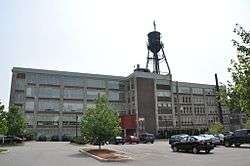 Dennison Manufacturing Co. Paper Box Factory |
November 19, 2008 (#08001070) |
175 Maple St. 42°20′29″N 71°32′36″W |
||
| 4 | Maplewood Cemetery |  Maplewood Cemetery |
September 29, 2004 (#04001082) |
Pleasant St. 42°21′13″N 71°33′49″W |
||
| 5 | Marlborough Brook Filter Beds | 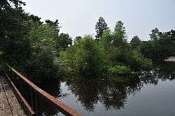 Marlborough Brook Filter Beds |
January 18, 1990 (#89002286) |
Framingham Rd. 42°19′47″N 71°32′09″W |
Extends into Southborough, Worcester County. | |
| 6 | Marlborough Center Historic District |  Marlborough Center Historic District |
August 19, 1998 (#98000992) |
Roughly bounded by MA 85, Granger Blvd., Mechanic St., Central St., and Washington St. 42°20′52″N 71°32′59″W |
||
| 7 | Pleasant Street Historic District |  Pleasant Street Historic District |
September 27, 2001 (#01001061) |
187-235 Pleasant St. 42°20′59″N 71°33′49″W |
||
| 8 | Capt. Peter Rice House | Capt. Peter Rice House |
April 9, 1980 (#80000641) |
377 Elm St. 42°20′51″N 71°34′30″W |
||
| 9 | Robin Hill Cemetery |  Robin Hill Cemetery |
September 29, 2004 (#04001083) |
Donald Lynch Blvd. 42°21′52″N 71°35′42″W |
||
| 10 | Rocklawn Cemetery |  Rocklawn Cemetery |
October 6, 2004 (#04001115) |
Stevens St. 42°21′10″N 71°32′27″W |
||
| 11 | Spring Hill Cemetery |  Spring Hill Cemetery |
October 6, 2004 (#04001114) |
High and Brown Sts. 42°20′53″N 71°32′34″W |
||
| 12 | Temple Building |  Temple Building |
March 10, 1983 (#83000830) |
149 Main St. 42°20′49″N 71°32′56″W |
||
| 13 | Wachusett Aqueduct Linear District |  Wachusett Aqueduct Linear District |
January 18, 1990 (#89002276) |
Along Wachusett Aqueduct from Wachusett Reservoir to Sudbury Reservoir 42°20′01″N 71°35′27″W |
||
| 14 | Warren Block |  Warren Block |
March 10, 1983 (#83000836) |
155 Main St. 42°20′49″N 71°32′56″W |
||
| 15 | Weeks Cemetery |  Weeks Cemetery |
September 10, 2004 (#04000934) |
Corner of Sudbury St. and Concord Rd. 42°22′23″N 71°29′53″W |
||
| 16 | West Main Street Historic District |  West Main Street Historic District |
November 8, 2001 (#01001215) |
West Main, Pleasant, Winthrop and Witherbee Sts. 42°20′39″N 71°33′27″W |
||
| 17 | Wilson Cemetery | 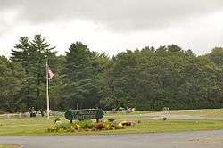 Wilson Cemetery |
September 10, 2004 (#04000958) |
Wilson St. 42°21′09″N 71°30′29″W |
References
| Wikimedia Commons has media related to National Register of Historic Places in Marlborough, Massachusetts. |
- "National Register of Historic Places: Weekly List Actions". National Park Service, United States Department of the Interior. Retrieved on June 26, 2020.
- Numbers represent an ordering by significant words. Various colorings, defined here, differentiate National Historic Landmarks and historic districts from other NRHP buildings, structures, sites or objects.
- "National Register Information System". National Register of Historic Places. National Park Service. April 24, 2008.
- The eight-digit number below each date is the number assigned to each location in the National Register Information System database, which can be viewed by clicking the number.
| Topics |  | ||||||||||||||||
|---|---|---|---|---|---|---|---|---|---|---|---|---|---|---|---|---|---|
| Lists by county | |||||||||||||||||
| Lists by city |
| ||||||||||||||||
| Other lists | |||||||||||||||||
| |||||||||||||||||
This article is issued from Wikipedia. The text is licensed under Creative Commons - Attribution - Sharealike. Additional terms may apply for the media files.