Garbeta
Garbeta is a census town in Garhbeta I CD Block in Medinipur Sadar subdivision of Paschim Medinipur district in the state of West Bengal, India. It is on the bank of the Shilabati. Gar in Bengali means a nullah. The boundary of the earlier town was surrounded by a small nullah.
Garhbeta | |
|---|---|
Census Town | |
.jpg) Garbeta railway station | |
 Garhbeta Location in West Bengal, India  Garhbeta Garhbeta (India) | |
| Coordinates: 22°52′N 87°22′E | |
| Country | |
| State | West Bengal |
| District | Paschim Medinipur |
| Population (2011) | |
| • Total | 5,109 |
| Languages | |
| • Official | Bengali, English |
| Time zone | UTC+5:30 (IST) |
| Vehicle registration | WB |
| Lok Sabha constituency | Jhargram |
| Vidhan Sabha constituency | Garbeta |
| Website | paschimmedinipur |
In this largest locality situated century old Garhbeta Bar Association to provide legal help to the people of Garhbeta.
.
Demographics
As per 2011 Census of India Garbeta had a total population of 5,109 of which 2,576 (50%) were males and 2,533 (50%) were females. Population below 6 years was 463. The total number of literates in Garbeta was 3,886 (76.06% of the population over 6 years).[1]
CD Block HQ
The headquarters of Garhbeta I Block are located at Garbeta.[2]
Police station
Garbeta police station has jurisdiction over parts of Garhbeta I, Garhbeta II, and Garhbeta III CD Blocks.[3][4]
Economy
The economy of this area is agriculturally based. The principal crops include rice, potatoes, wheat, and vegetables of different kinds. Some villagers are engaged in fishing, hawking and weaving. A small percentage of the townspeople are government employees and school teachers. Most of the people are middle class to lower middle class. Roy Tyre Centre,[5][6] the new MRF exclusive store caters all the tyre requirements of transport business, as well as other vehicle needs in and around Garhbeta.
Transportation
Garbeta is well connected by highways and railways with nearby cities like Midnapore, Kharagpur, Bankura, Ghatal, Howrah etc. For local transportation bus, minibus, auto rickshaws and van rickshaws are available. There is also a railway station named Garbeta railway station. Station Code is GBA.
Education
There are number of well known schools in Garbeta, including Garbeta High School, Banerjee Danga High School, Saradamani Girls' High School, Garhbeta Umadevi Girls High School and Monglapota High School. The only college here is Garbeta College[7] which is part of Vidyasagar University.[8] There are also non-governmental educational organizations in or near Garbeta including "Raksha Bandhan For Education", "Kishalaya Free Coaching Center" and the "Garbeta Science Association".
Health
There is a rural hospital in Garbeta, as well as many private medical practitioners. Overall, the population is generally healthy.
Sarva Mangala temple
There are a number of temples in Garbeta but particular mention has to be made of the temple of Sarva Mangala. It is peculiar in having its door facing the north. According to the tradition, during the days of Maharaja Vikramaditya of Ujjain a yogi was wandering about in the thick of the forests and was attracted to this particular place. He immediately brought about a temple of Sarva Mangala Devi through his mantras.
Maharaja Vikramaditya came to know of the dynamic force of this and came to Garbeta where he performed a tantric sadhana sitting on a dead body. The Devi was pleased with the sadhana of the Maharaja, blessed him with supernatural powers and gave him the services of Tal and Betal. The Maharaja wanted to test the spiritual power conferred on him by the Devi and asked Tal and Betal to turn the temple and make it face the north. Tal and Betal did so and it is said that the name Garbeta derives its name from Tal and Betal.
Festivals
There are many festivals in Garbeta. There is one rural organization named Prayas which promotes all manner of cultural events. There are some religious sites, among which Sarbangala Mandir is most popular. The regular Bengali festivals like Durga Puja, Lakshmi Puja, Saraswati Puja and Kali Puja are well attended. Other common pujas are Shitala, Jagaddhatri, Holi and Bheema.
Famous Tourist Spots
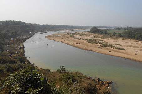
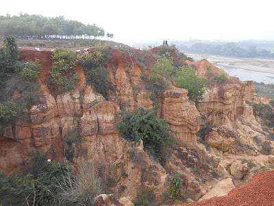
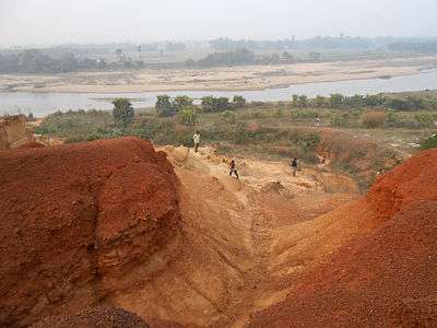
- Gangani - A natural hill on the river bank which is a very popular picnic spot. It is a natural river canyon and has different spectacular types of formation due to soil erosion.
- Sarbamangala Mandir -The largest temple on the north side of Mangala lake, it shows the influence of Oriya architecture.
- Raikota Fort - Some of the most prominent architectural remains are the ruins of an old fort. At the entrance to the fort are four massive gateways which still bear their old names: Lal Darwaja, Hanuman Darwaja, Pesha Darwaja and Rauti Darwaja. Within the fort there are seven large silted up water ponds, each with a temple in the center. They all lie towards the north of the fort and it is believed that they were excavated between 1555-1610 A.D. in the time of the Chauhan Rajas of Bagri.
- Bagri's Krishnarai Jiu Temple - The temple is situated at the left bunk of the river Silaboti. It has five pillars and is a pure example of Bengali architecture. It was built by Rajyadhar Roy, minister for the first king of Bagri, Gajapati Singha. The idol of Lord Krishna is made of black basalt stone.
- Kameshwar Temple and Radhaballav Temple - Both the temples are famous and one can see some similarity with Sarbamangala Temple . Radhaballav temple is a mixture of Oriya and Bengali architecture.
- Raghunathji Temple, Raghunath Bari - It is situated at the southern part of river Silaboti and has nine pillars. Raghunath or Bishnupur's Adi Malla made this temple.
- Uriyasaier Temple - The remains of a stone temple, made by Chouhan Singha.
- Jhalda Fort, Nayabasat - The remains of Bagri king Ganapati Singha's fort.

Further reading
- History of Bagree-Rajya (Garhbeta): with Special Reference to its Anti-British Role, from Late 18th century Till the Present Times by Gouripada Chatterjee, foreword by R.C. Majumdar. Edition: 2nd rev., Delhi, India : Mittal Publications, 1987. ISBN 81-7099-014-9
See also
References
- "2011 Census – Primary Census Abstract Data Tables". West Bengal – District-wise. Registrar General and Census Commissioner, India. Retrieved 27 October 2016.
- "District Census Handbook: Paschim Medinipur" (PDF). Map of Paschim Medinipur with CD Block HQs and Police Stations (on the fifth page). Directorate of Census Operations, West Bengal, 2011. Retrieved 20 November 2016.
- "District Statistical Handbook 2014 Paschim Medinipur". Tables 2.1, 2.2. Department of Statistics and Programme Implementation, Government of West Bengal. Archived from the original on 29 July 2017. Retrieved 14 October 2016.
- "District at a Glance". Paschim Medinipur District Police. Retrieved 27 October 2016.
- Roy Tyre Centre MRF Exclusive
- https://goo.gl/maps/uobHagZUo642
- Garbeta College website
- Vidyasagar University website
External links
| Wikimedia Commons has media related to Garbeta. |
- Prayas cultural club research work on the history of Garbeta.
- Prayas photogallery of Garbeta.
- History of Garhbeta.
- Garhbeta.in.
- Transportation System Information of Garhbeta.
- Important Telephone-Directory.
- Paschim Medinipur District Official Website
- Purba Medinipur District Official Website
- Midnapore - Website for East and West Midnapore
- On temples of Midnapur
Cities, towns and locations in Paschim Medinipur District | |||||||
|---|---|---|---|---|---|---|---|
| Cities, municipal and census towns |
| ||||||
| Locations other than cities and towns |
| ||||||
| Related topics |
| ||||||