Pennsylvania Route 729
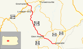
Pennsylvania Route 729 (PA 729) is a 22.07-mile-long (35.52 km), north–south state highway located in Clearfield County, Pennsylvania. The southern terminus is at PA 253/PA 453 in Gulich Township. The northern terminus is at US 219/PA 879 in Grampain.
| |||||||
|---|---|---|---|---|---|---|---|
 | |||||||
| Route information | |||||||
| Maintained by PennDOT | |||||||
| Length | 22.077 mi[1] (35.529 km) | ||||||
| Major junctions | |||||||
| South end | |||||||
| North end | |||||||
| Location | |||||||
| Counties | Clearfield | ||||||
| Highway system | |||||||
| |||||||

Route description
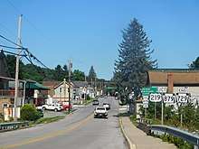
PA 729 is known by two names along its route. The two names it goes by are Main Street, and more commonly, the Tyrone Turnpike.[1]
The route begins at the village of Janesville at an intersection of PA 253/PA 453. The route heads northwest to the town of Glen Hope, where the route has an intersection with PA 53. The route continues north to the town of Lumber City. In the town, the route has a short concurrency with PA 969. The route continues north to the town of Grampian, where the route terminates at an intersection with US 219 and PA 879.[2]
History
PA 729 was first signed in 1930, but as a short route in Berks County, from PA 100 (Then PA 62) to PA 29. In the mid-1940s, the route was decommissioned, but in 1969, the route number was revived for its current location today. A very small portion of the current route was signed as PA 825 during the 1930s and early 1940s.[3][4]
Major intersections
The entire route is in Clearfield County.
| Location | mi[1] | km | Destinations | Notes | |
|---|---|---|---|---|---|
| Gulich Township | 0.000 | 0.000 | |||
| Glen Hope | 5.778 | 9.299 | |||
| Lumber City | 17.870 | 28.759 | Southern terminus of concurrency | ||
| 18.213 | 29.311 | Northern terminus of concurrency | |||
| Grampian | 22.077 | 35.529 | |||
1.000 mi = 1.609 km; 1.000 km = 0.621 mi
| |||||
See also


References
- "Pennsylvania state roads". Pennsylvania Spatial Data Access. Pennsylvania Department of Transportation. 2013. Retrieved March 14, 2013.
- Google (May 12, 2013). "Pennsylvania Route 729" (Map). Google Maps. Google. Retrieved May 12, 2013.
- "Archived copy" (PDF). Archived from the original (PDF) on 2011-07-05. Retrieved 2014-01-01.CS1 maint: archived copy as title (link)
- ftp://ftp.dot.state.pa.us/public/pdf/BPR_PDF_FILES/Maps/Type_10_GHS_Historical_Scans/Clearfield_1977_Sheet_1.pdf
External links
| Wikimedia Commons has media related to Pennsylvania Route 729. |