City of Brisbane
The City of Brisbane is a local government area over the inner portion of the metropolitan area of Brisbane, the capital of Queensland, Australia. Respectively, the Brisbane City Council has jurisdiction over that area as the local government. Brisbane is located in the county of Stanley and is the largest city followed by Ipswich with bounds in part of the county. Unlike LGAs in the other mainland state capitals (Sydney, Melbourne, Perth and Adelaide), which are generally responsible only for the central business districts and inner neighbourhoods of those cities, the City of Brisbane administers a significant portion of the Brisbane metropolitan area, serving almost half of the population of the Brisbane Greater Capital City Statistical Area (GCCSA, formerly statistical division). As such, it has a larger population than any other local government area in Australia.[2] The City of Brisbane was the first Australian LGA to reach a population of more than one million.[3] Its population is roughly equivalent to the populations of Tasmania, the Australian Capital Territory and the Northern Territory combined. In 2016–2017, the council administers a budget of over $3 billion,[4] by far the largest budget of any LGA in Australia.
| City of Brisbane Queensland | |||||||||||||||
|---|---|---|---|---|---|---|---|---|---|---|---|---|---|---|---|
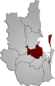 Map of Brisbane City in South East Queensland | |||||||||||||||
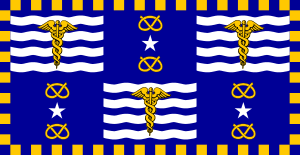 Flag of the City of Brisbane | |||||||||||||||
| Coordinates | 27.47°S 153.12°E | ||||||||||||||
| Population | 1,231,605 (2018)[1] (1st) | ||||||||||||||
| • Density | 917.26/km2 (2,375.69/sq mi) | ||||||||||||||
| Established | 1924 | ||||||||||||||
| Area | 1,342.7 km2 (518.4 sq mi)[1] | ||||||||||||||
| Time zone | AEST (UTC+10:00) | ||||||||||||||
| Lord Mayor | Adrian Schrinner | ||||||||||||||
| Council seat | Brisbane CBD (City Hall) | ||||||||||||||
| Region | South East Queensland | ||||||||||||||
| State electorate(s) | Algester, Aspley, Bulimba, Chatsworth, Clayfield, Cooper, Everton, Ferny Grove, Greenslopes, Inala, Lytton, Maiwar, Mansfield, McConnel, Miller, Moggill, Mount Ommaney, Nudgee, Sandgate, South Brisbane, Stafford, Stretton, Toohey | ||||||||||||||
| Federal Division(s) | Brisbane, Bonner, Dickson, Griffith, Lilley, Moreton, Oxley, Petrie, Ryan | ||||||||||||||
 | |||||||||||||||
| Website | City of Brisbane | ||||||||||||||
| |||||||||||||||
The City derives from cities, towns and shires that merged in 1925. The main offices and Central Library of the Council are at 266 George Street, also known as Brisbane Square. Brisbane City Hall houses the Council Chamber, the offices of the Lord Mayor and Deputy Mayor, meeting and reception rooms and the Museum of Brisbane.
Wards
As of the election in 2020, the twenty-six wards, their councillors and their party affiliations were:[5]
| Party | Wards | Current Chamber (Total 26 Wards) | |
|---|---|---|---|
| Liberal National | 19 | ||
| Labor | 5 | ||
| Greens | 1 | ||
| Independent | 1 | ||
| Ward | Party | Councillor | |
|---|---|---|---|
| Bracken Ridge | LNP | Sandy Landers[6] | |
| Calamvale | LNP | Angela Owen-Taylor[7] | |
| Central | LNP | Vicki Howard[8] | |
| Chandler | LNP | Ryan Murphy[9] | |
| Coorparoo | LNP | Fiona Cunningham[10] | |
| Deagon | Labor | Jared Cassidy[11] | |
| Doboy | LNP | Lisa Atwood[12] | |
| Enoggera | LNP | Andrew Wines[13] | |
| Forest Lake | Labor | Charles Strunk[14] | |
| Hamilton | LNP | David McLachlan[15] | |
| Holland Park | LNP | Krista Adams[16] | |
| Jamboree | LNP | Sarah Hutton[17] | |
| MacGregor | LNP | Steven Huang[18] | |
| Marchant | LNP | Fiona Hammond[19] | |
| McDowall | LNP | Tracy Davis[20] | |
| Moorooka | Labor | Steve Griffiths[21] | |
| Morningside | Labor | Kara Cook[22] | |
| Northgate | LNP | Adam Allan[23] | |
| Paddington | LNP | Peter Matic[24] | |
| Pullenvale | LNP | Greg Adermann[25] | |
| Runcorn | LNP | Kim Marx[26] | |
| Tennyson | Independent | Nicole Johnston[27] | |
| The Gabba | Greens | Jonathan Sri[28] | |
| The Gap | LNP | Steven Toomey[29] | |
| Walter Taylor | LNP | James Mackay[30] | |
| Wynnum Manly | Labor | Peter Cumming[31] | |
Suburbs
The City of Brisbane includes the following settlements:
Inner suburbs
Total: 19
Northern suburbs
- Albion
- Alderley
- Ascot
- Aspley
- Bald Hills
- Banyo
- Boondall
- Bracken Ridge
- Bridgeman Downs
- Brighton
- Brisbane Airport
- Carseldine
- Chermside
- Chermside West
- Clayfield
- Deagon
- Eagle Farm
- Everton Park
- Fitzgibbon
- Gaythorne
- Geebung
- Gordon Park
- Grange
- Hamilton
- Hendra
- Kedron
- Keperra
- Lutwyche
- McDowall
- Mitchelton
- Myrtletown
- Newmarket
- Northgate
- Nudgee
- Nudgee Beach
- Nundah
- Pinkenba
- Sandgate
- Shorncliffe
- Stafford
- Stafford Heights
- Taigum
- Virginia
- Wavell Heights
- Wilston
- Windsor
- Wooloowin
- Zillmere
Total: 48
Southern suburbs
- Acacia Ridge
- Algester
- Annerley
- Archerfield
- Burbank
- Calamvale
- Coopers Plains
- Darra
- Doolandella
- Drewvale
- Durack
- Dutton Park
- Eight Mile Plains
- Ellen Grove
- Fairfield
- Forest Lake
- Greenslopes
- Heathwood
- Holland Park
- Holland Park West
- Inala
- Karawatha
- Kuraby
- Larapinta
- MacGregor
- Mackenzie
- Mansfield
- Moorooka
- Mount Gravatt
- Mount Gravatt East
- Nathan
- Pallara
- Parkinson
- Richlands
- Robertson
- Rochedale
- Rocklea
- Runcorn
- Salisbury
- Seventeen Mile Rocks
- Sinnamon Park
- Stretton
- Sumner
- Sunnybank
- Sunnybank Hills
- Tarragindi
- Tennyson
- Upper Mount Gravatt
- Wacol
- Willawong
- Wishart
- Yeerongpilly
- Yeronga
Total: 54
Eastern suburbs
Total: 28
Western suburbs
- Anstead
- Ashgrove
- Auchenflower
- Banks Creek
- Bellbowrie
- Brookfield
- Chapel Hill
- Chelmer
- Chuwar
- Corinda
- England Creek
- Enoggera
- Enoggera Reservoir
- Ferny Grove
- Fig Tree Pocket
- Graceville
- Indooroopilly
- Jamboree Heights
- Jindalee
- Karana Downs
- Kenmore
- Kenmore Hills
- Kholo
- Lake Manchester
- Middle Park
- Milton
- Moggill
- Mount Coot-tha
- Mount Crosby
- Mount Ommaney
- Oxley
- Pinjarra Hills
- Pullenvale
- Riverhills
- Sherwood
- Sinnamon Park
- St Lucia
- Taringa
- The Gap
- Toowong
- Upper Brookfield
- Upper Kedron
- Westlake
Total: 43
History
.jpg)

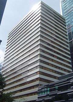
The Government of Queensland created the City of Brisbane with a view to uniting the then Brisbane metropolitan area under a single planning and governance structure. The City of Brisbane Act 1924 received assent from the Governor on 30 October 1924. On 1 October 1925, 20 local government areas of various sizes were abolished and merged into the new city,[32] namely:
- Cities:
- Brisbane
- South Brisbane
- Towns:
- Shires:
The Council also assumed responsibility for several quasi-autonomous government authorities, such as the Brisbane Tramways Trust.
Demographics
| Selected historical census data for City of Brisbane local government area | ||||||
|---|---|---|---|---|---|---|
| Census year | 2001[33] | 2006[34] | 2011[35] | 2016[36] | ||
| Population | Estimated residents on census night | 873,780 | 956,129 | 1,041,839 | 1,131,155 | |
| LGA rank in terms of size within Queensland | 1st | |||||
| % of Queensland population | 24.37% | |||||
| % of Australian population | 4.66% | |||||
| Cultural and language diversity | ||||||
| Ancestry, top responses | English | 25.0% | ||||
| Australian | 23.1% | |||||
| Irish | 9.5% | |||||
| Scottish | 7.4% | |||||
| Chinese | 4.1% | |||||
| Language, top responses (other than English) | Mandarin | 1.4% | ||||
| Cantonese | 1.4% | |||||
| Vietnamese | 1.3% | |||||
| Italian | 1.1% | |||||
| Greek | 0.8% | |||||
| Spanish | 0.7% | |||||
| Korean | 1.0% | |||||
| Religious affiliation | ||||||
| Religious affiliation, top responses | Catholic | 28.0% | ||||
| Anglican | 19.5% | |||||
| No religion | 15.0% | |||||
| Uniting | 7.8% | |||||
| Presbyterian | 3.7% | |||||
| Buddhism | 3.0% | |||||
| Median weekly incomes | ||||||
| Personal income | Median weekly personal income | A$556 | A$696 | A$770 | ||
| % of Australian median income | 119.3% | 120.6% | 116.3% | |||
| Family income | Median weekly family income | A$1403 | A$1873 | A$2091 | ||
| % of Australian median income | 119.8% | 126.5% | 120.6% | |||
| Household income | Median weekly household income | A$1157 | A$1547 | A$1746 | ||
| % of Australian median income | 112.7% | 125.4% | 121.4% | |||
| Dwelling structure | ||||||
| Dwelling type | Separate house | 74.7% | ||||
| Semi-detached, terrace or townhouse | 6.7% | 7.9% | ||||
| Flat or apartment | 17.2% | |||||
Heritage
The Brisbane City Council maintains the Brisbane Local Heritage Register, a list of nominated sites that satisfy the Council's heritage criteria.[37]
Governance
The City of Brisbane is governed by the Brisbane City Council, the largest local council in Australia. The Brisbane City Council has its power divided between a Lord Mayor, a parliamentary-style council of twenty-six councillors representing single-member wards of approximately 30,000 voters[38] (roughly equivalent in size to state electorates), and a Civic Cabinet comprising the Lord Mayor, the Deputy Mayor (drawn from the majority on Council) and the chairpersons of the seven standing committees drawn from the membership of Council. Due to the City of Brisbane's status as the country's largest LGA, the Lord Mayor is elected by the largest single-member electorate in Australia. Like all mayors in Queensland, they hold very broad executive power.
The Brisbane City Council operates under the City of Brisbane Act 2010, while other local governments in Queensland are governed by the Local Government Act 2009. Council meetings are held at Level 2, City Hall, 64 Adelaide Street, Brisbane City[39] every Tuesday at 2pm except during recess and holiday periods. This temporary venue is in use due to the restoration work being performed on the traditional venue Brisbane City Hall.[40] Council Meetings generally open to the public, excluding the Civic Cabinet.
Heraldry
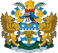
The motto of the City of Brisbane is Meliora sequimur, Latin for We aim for better things. The Council's corporate slogan is Dedicated to a better Brisbane. The City's colours are blue and gold. Its corporate logo was introduced in 1982 in preparation for the Commonwealth Games hosted in Brisbane that year. It features a stylised version of Brisbane's City Hall which opened in 1930. The City's floral emblem is the (exotic) poinsettia and its faunal emblem is the graceful tree frog.
Amenities
Brisbane City Council operate libraries in Annerley, Ashgrove, Banyo, Bracken Ridge, Brisbane CBD (Brisbane Square), Bulimba, Carina, Carindale (Westfield Carindale), Chermside, Coopers Plains, Corinda, Everton Park, Fairfield, Upper Mount Gravatt (Garden City), Grange, Hamilton, Holland Park, Inala, Indooroopilly, Kenmore, Mitchelton, Mount Coot-tha (Botanic Gardens), Mount Gravatt, Mount Ommaney, New Farm, Nundah, Sandgate, Stones Corner, Sunnybank Hills, Toowong, West End, Wynnum, and Zillmere.[41] In addition, it operates a mobile library service to Aspley, Bellbowrie, Brighton, Ellen Grove, Forest Lake, Manly West, Mount Crosby and The Gap.[42] There is also a pop-up library that attends community events and festivals, as well as visiting various parks around Brisbane for children's storytime sessions (a list of dates and places is published some months in advance).[43]
Sister cities
The City of Brisbane has nine sister cities.[44][45][46]
| City | Country | Commenced |
|---|---|---|
| Abu Dhabi | United Arab Emirates | 2 February 2009 |
| Auckland | New Zealand | August 1988 |
| Chongqing | China | October 2005 |
| Daejeon | South Korea | 17 June 2002 |
| Hyderabad[47] | India | 5 October 2010 |
| Kaohsiung | Taiwan | September 1997 |
| Kobe[48] | Japan | July 1985 |
| Semarang | Indonesia | January 1993 |
| Shenzhen[49][50][51] | China | June 1992 |
Nice, France was formerly a sister city of Brisbane until the relationship was severed in 1995 as protest against the Chirac government's decision to resume nuclear testing in the Pacific Ocean.[52] Bangkok became a sister city of Brisbane on 7 May 1997, but is no longer listed as a sister city on the Brisbane City Council website.[53][54] Brisbane does not have any sister city relationship with any North American, South American, African or any European city.[55]
See also
References
- "3218.0 – Regional Population Growth, Australia, 2017-18: Population Estimates by Local Government Area (ASGS 2018), 2017 to 2018". Australian Bureau of Statistics. Australian Bureau of Statistics. 27 March 2019. Archived from the original on 27 March 2019. Retrieved 25 October 2019. Estimated resident population, 30 June 2018.
- "Table 1: Population growth and turnover in Local Government Areas (LGAs), 2006 to 2011". Australian Bureau of Statistics. Retrieved 10 August 2015.
- Hiroaki Suzuki; Arish Dastur; Sebastian Moffatt; Nanae Yabuki; Hinako Maruyama (2010). Eco2 Cities: Ecological Cities as Economic Cities. World Bank. p. 213. ISBN 978-0-8213-8046-8. Archived from the original on 17 December 2010. Retrieved 12 March 2011.
- "Council Annual Plan and Budget 2016–17". Brisbane City Council. 2 June 2017. Archived from the original on 19 June 2017. Retrieved 19 June 2017.
- "2016 Brisbane City Council – Councillor Election – Election Summary". Electoral Commission of Queensland. 19 April 2016. Archived from the original on 7 June 2016. Retrieved 10 June 2016.
- "Bracken Ridge Ward". Electoral Commission of Queensland. Retrieved 24 April 2020.
- "Calamvale Ward". Electoral Commission of Queensland. Retrieved 24 April 2020.
- "Central Ward". Electoral Commission of Queensland. Retrieved 24 April 2020.
- "Chandler Ward". Electoral Commission of Queensland. Retrieved 24 April 2020.
- "Coorparoo Ward". Electoral Commission of Queensland. Retrieved 24 April 2020.
- "Deagon Ward". Electoral Commission of Queensland. Retrieved 24 April 2020.
- "Doboy Ward". Electoral Commission of Queensland. Retrieved 24 April 2020.
- "Enoggera Ward". Electoral Commission of Queensland. Retrieved 24 April 2020.
- "Forest Lake Ward". Electoral Commission of Queensland. Retrieved 24 April 2020.
- "Hamilton Ward". Electoral Commission of Queensland. Retrieved 24 April 2020.
- "Holland Park Ward". Electoral Commission of Queensland. Retrieved 24 April 2020.
- "Jamboree Ward". Electoral Commission of Queensland. Retrieved 24 April 2020.
- "MacGregor Ward". Electoral Commission of Queensland. Retrieved 24 April 2020.
- "Marchant Ward". Electoral Commission of Queensland. Retrieved 24 April 2020.
- "McDowall Ward". Electoral Commission of Queensland. Retrieved 24 April 2020.
- "Moorooka Ward". Electoral Commission of Queensland. Retrieved 24 April 2020.
- "Morningside Ward". Electoral Commission of Queensland. Retrieved 24 April 2020.
- "Northgate Ward". Electoral Commission of Queensland. Retrieved 24 April 2020.
- "Paddington Ward". Electoral Commission of Queensland. Retrieved 24 April 2020.
- "Pullenvale Ward". Electoral Commission of Queensland. Retrieved 24 April 2020.
- "Runcorn Ward". Electoral Commission of Queensland. Retrieved 24 April 2020.
- "Runcorn Ward". Electoral Commission of Queensland. Retrieved 24 April 2020.
- "The Gabba Ward". Electoral Commission of Queensland. Retrieved 24 April 2020.
- "The Gap Ward". Electoral Commission of Queensland. Retrieved 24 April 2020.
- "Walter Taylor Ward". Electoral Commission of Queensland. Retrieved 24 April 2020.
- "Wynnum Manly Ward". Electoral Commission of Queensland. Retrieved 24 April 2020.
- City of Brisbane Act 1924 Archived 13 March 2011 at the Wayback Machine (accessed 23 January 2011)
- Australian Bureau of Statistics (9 March 2006). "City of Brisbane (C)". 2001 Census QuickStats. Retrieved 3 December 2017.
- Australian Bureau of Statistics (25 October 2007). "City of Brisbane (C)". 2006 Census QuickStats. Retrieved 3 December 2017.
- Australian Bureau of Statistics (31 October 2012). "City of Brisbane (C)". 2011 Census QuickStats. Retrieved 3 December 2017.

- Australian Bureau of Statistics (27 June 2017). "Brisbane (C)". 2016 Census QuickStats. Retrieved 16 November 2017.
- "QUEENSLAND HERITAGE ACT 1992 – SECT 113". Queensland Consolidated Acts. Queensland Government. Archived from the original on 22 February 2014. Retrieved 14 September 2012.
- "Summary of Current Enrolment per Ward (Enrolment figures as at 31 January 2019)" (PDF). Brisbane City Council. Archived from the original (PDF) on 15 May 2019. Retrieved 15 May 2019.
- "Meeting dates & locations". Brisbane City Council. Archived from the original on 8 August 2014. Retrieved 21 March 2010.
- "City Hall Restoration". Brisbane City Council. Archived from the original on 7 August 2014. Retrieved 21 March 2010.
- "Library opening hours and locations". Brisbane City Council. 3 January 2018. Archived from the original on 30 January 2018. Retrieved 29 January 2018.
- "Mobile library services". Brisbane City Council. Archived from the original on 29 January 2018. Retrieved 29 January 2018.
- "The Pop-up Library". Brisbane City Council. 5 June 2017. Archived from the original on 29 January 2018. Retrieved 29 January 2018.
- Yamashita, Kate (9 December 2016). "Brisbane Sister Cities". www.brisbane.qld.gov.au. Archived from the original on 17 April 2017. Retrieved 17 April 2017.
- "Facts & Statistics". Our Brisbane. Archived from the original on 14 October 2007. Retrieved 2 January 2008.
- "List of Sister Cities". www.brisbane.qld.gov.au. Brisbane City Council. Archived from the original on 21 March 2016. Retrieved 21 March 2016.
- Moore, Tony. "Brisbane signs new sister city deal". Brisbane Times. Archived from the original on 5 January 2017. Retrieved 21 March 2016.
- "Kobe's Sister Cities". Kobe Trade Information Office. Archived from the original on 21 April 2013. Retrieved 11 August 2013.
- 友好城市 (Friendly cities) Archived 19 July 2014 at the Wayback Machine, 市外办 (Foreign Affairs Office), 22 March 2008. (Translation by Google Translate.)
- 国际友好城市一览表 (International Friendship Cities List) Archived 13 November 2013 at the Wayback Machine, 20 January 2011. (Translation by Google Translate.)
- 友好交流 (Friendly exchanges) Archived 12 November 2014 at the Wayback Machine, 13 September 2011. (Translation by Google Translate.)
- Thomas, Nicholas (2004). Re-Orienting Australia-China Relations: 1972 to the Present. Australia: Ashgate Publishing, Ltd. p. 75. ISBN 0-7546-3245-8. Archived from the original on 17 April 2017. Retrieved 12 January 2008.
- "Sister Cities – Brisbane City Council". Retrieved 19 June 2017.
- "Brisbane". International Affairs Division – Bangkok Metropolitan Administration. Archived from the original on 18 April 2017.
- "Brisbane Sister Cities". Brisbane City Council. Archived from the original on 19 June 2017. Retrieved 19 June 2017.
External links
- Official website
- Brisbane City Council's Organisational Structure
- "Brisbane and Greater Brisbane". Queensland Places. Centre for the Government of Queensland, University of Queensland.
- Google map of pre 1925 merger Brisbane Councils