Nundah, Queensland
Nundah (previously called German Station) is an inner suburb in the City of Brisbane, Queensland, Australia.[4] In the 2016 census, Nundah had a population of 12,141 people.[1]
| Nundah Brisbane, Queensland | |||||||||||||||
|---|---|---|---|---|---|---|---|---|---|---|---|---|---|---|---|
 | |||||||||||||||
 Nundah | |||||||||||||||
| Coordinates | 27.4025°S 153.0636°E | ||||||||||||||
| Population | 12,141 (2016 census)[1] | ||||||||||||||
| • Density | 3,110/km2 (8,060/sq mi) | ||||||||||||||
| Postcode(s) | 4012 | ||||||||||||||
| Area | 3.9 km2 (1.5 sq mi) | ||||||||||||||
| Time zone | AEST (UTC+10:00) | ||||||||||||||
| Location | 8.9 km (6 mi) NNE of Brisbane GPO | ||||||||||||||
| LGA(s) | City of Brisbane (Hamilton Ward;[2] Northgate Ward)[3] | ||||||||||||||
| State electorate(s) | Nudgee | ||||||||||||||
| Federal Division(s) | Lilley | ||||||||||||||
| |||||||||||||||
Prior to European settlement, Nundah was inhabited by Aboriginal people from the Turrbul tribe. Nundah is primarily a residential suburb, which straddles Sandgate Road, one of the major arterial roads of Brisbane's north. It was first settled by Europeans in the mid-19th century, although the suburb remained primarily a rural area until it was connected to Brisbane via railway in the 1880s.[5] Originally considered a working-class suburb, the area has become gentrified in recent years, and today features a mix of traditional worker's cottages and modern high-density apartment blocks. It is close to the Centro Shopping Centre.
Geography
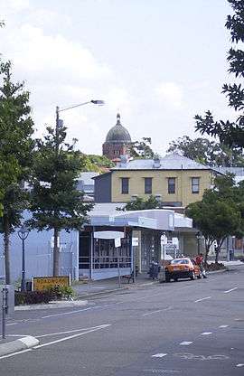
Nundah is a mixed-density residential suburb, with some light industry and a commercial retail area concentrated on Sandgate Road. It is adjacent to the suburbs of Clayfield, Northgate and Wavell Heights, and is dominated by a large ridge that runs from the northwest to the southeast. The "Nundah Village" shopping district and Nundah State School are on this ridge, while the George Bridges Tunnel bisects it along Sandgate Road.[6]
The suburb includes the locality and formerly distinct suburb of Toombul, which is centred in the south of Nundah, around Sandgate Road. Various facilities in Nundah are named after this locality, including the large shopping centre Centro Toombul, Toombul Bus Station and the Toombul railway station.
Schulz Canal runs through Nundah, bisecting the Toombul Shopping Centre Carpark. The low elevation of the carpark makes it particularly susceptible to flash flooding during peak storm seasons – often claiming the cars of unwary shoppers inside the centre and those attempting to cross the Melton Road bridge. The estuary of the canal is a moderately popular recreational fishing spot.
College Estate, Nundah was advertised for public auction on Saturday 5 June 1937 by Cameron Brothers auctioneers. 54 splendid residential sites occupying one of the finest positions in Nundah were for sale.[7][8]
History
Aboriginal history
Like most of Northern Brisbane,[9] the area around Nundah was dominated by the Turrbul tribe.[10] Their traditional coastal trade route passed through Nundah, near the modern-day Hedley Avenue. There are also many significant Aboriginal sites near Nundah, such as Dinah Island, which was reportedly the site of the last traditional Aboriginal burial in the Brisbane area.[10] There were a number of bora rings in the area, indicating that the Nundah area was densely populated by Aboriginal people before European settlers arrived.[11]
European settlement
German mission
The first permanent European settlement in the area was a mission built in 1838 by German Lutheran missionaries,[12] under the guidance of Reverend Carl Wilhelm Schmidt and later Reverend Christoph Eipper with the aim of bringing Christianity to the local Aboriginal people.[13][14] They first called the area "Zion",[6] and the mission was located in the vicinity of the modern-day street "Walkers Way".[15] It later became "German Station". The explorer Dr. Ludwig Leichhardt visited the area in 1843, and spoke very highly of the mission, but despite this the mission met with limited success and was closed at the behest of the colonial government in 1846.[14] This first settlement is nonetheless commemorated with a monument at the corner of Sandgate Road and Wood Street unveiled in 1938 by the then Premier of Queensland William Forgan Smith. The names of these German settlers can be seen in the names of streets in Nundah and surrounding suburbs such as Rode Road and Gerler Road.
Growth of the village of German Station
A prominent local citizen who contributed significantly to the development of the village of German Station was George Bridges (1820–1898). George and his young family immigrated from Wilstead, Bedfordshire, England to Queensland in 1852 aboard the "Marie Somes". In 1855, he acquired 64 acres (26 ha) of land north of Buckland Road and east of Sandgate Road for farming. However, as Sandgate became an increasingly popular holiday destination, the increasing volume of coach traffic along Sandgate Road encouraged him to open a hotel, which became a popular stop being roughly halfway between Brisbane and Sandgate. The first hotel was called the Kedron Hotel but the third and longest-running hotel was known as the Kedron Brook Hotel and was located alongside Sandgate Road (now Bage St) on the SW corner of his property. Emboldened by the success of his hotel ventures, George Bridges looked for other commercial opportunities. He observed that Sandgate Road at that time did a dog-leg around the SW corner of his property (along Buckland Road) which forced traffic to travel up and over Donkin's Hill. So he created a short-cut across the SW corner of his property that avoided the hill, which was much appreciated by the travellers, allowing George Bridges to sell off parcels of land along this new unofficial piece of Sandgate Road to commercial enterprises, which serviced both the travellers and the local farming community. This unofficial short-cut grew into the Nundah Village shopping street that exists today and eventually became the official route of Sandgate Road. Around 1872, George and his wife Mary retired to Burpengary and began to progressively sell off the land of their German Station property as the village developed.
Creation of the suburb of Nundah
German Station State School opened on 2 October 1865 and was renamed Nundah State School in 1895.[16][17]
German Station remained an agricultural area until the 1880s. In 1881, Queensland State Government purchased a strip of land across George Bridges's property to build a railway link between Brisbane and Sandgate. The railway opened in 1882 and resulted in a suburban residential construction boom on Brisbane's northside.[5] This urban sprawl was also encouraged by the Undue Subdivision of Land Prevention Act 1885, which mandated minimum lot sizes for new urban developments.[18] The village of German Station became known as a location where working-class families could obtain cheap housing on reasonably sized lots not too far from the city. George Bridges sold off his remaining land for residential development in the new suburb.
A railway station called German was created in 1882 (again on land originally owned by George Bridges), because they wanted the station to be called German Station rather than German Station Station.[19] However, six weeks after the railway station opened, it was renamed Nundah.[20] The name Nundah is a corruption of the Yuggera language, Turrbal dialect word nanda meaning chain of water holes.[4][21][22] This name is probably a reference to the nearby natural water sources at Kedron Brook and the marshy areas formerly to the east of the suburb.[23] In 1888, the name of the Post Office was also changed to Nundah,[24] signalling the renaming of the new suburb. However, the name German Station persisted for many years. For many years it was common to find references to Nundah with the annotation "formerly German Station" in newspapers and advertisements, until the name Nundah was well established.
In 1883 William Alexander Jenyns Boyd relocated his Eton Preparatory School from Milton (where it was established in 1877[25]) to Nundah, where he erected new buildings at a cost of £3,000 on a 10-acre (4.0 ha) site.[26] In 1889 Boyd was forced to close the school due to economic hardships preventing families being able to afford to send their sons to boarding school, but he re-opened the school in 1891. However the impacts of the 1893 Brisbane flood forced him to close the school permanently.[27][28] In June 1893 the Sisters of the Society of the Sacred Advent acquired Eton House to run a boarding school for orphan girls called The Home of the Good Shepherd,[29][30] which in 1894 also took in paying students as well with Miss Isabelle Caine as headmistress under the management of Sister Emma.[31][32] In 1897 the orphans were relocated to Ormiston Place, leaving Eton House as a private boarding school known as the Eton High School for Girls.[33][34] In 1907, the school relocated to Toorak House in Hamilton[35] and then in 1910 to Albion Heights (now Ascot) where it is known as St Margaret's Anglican Girls' School.[36] In 1907 the St Francis Anglican Theological College moved into Eton House under Canon Tomlin.[37] In 1936-7 the theological college relocated to Bishopsbourne in Milton.[38] By June 1937 Eton House had been sold for removal and its grounds subdivided,[39][38][40] but the site is believed to be bounded by Bishop Street, Buckland Road, Wand Street and Olive Street (27.4010°S 153.0524°E). Boyd Road leads to this area and presumably commemorates Boyd who established the site.[30]
From 1890, Nundah was the seat of the Shire of Toombul, which was absorbed into the City of Greater Brisbane in 1925.[41][42] The Toombul Shire Hall still exists as a community centre.[42]
In 1909, Surrey Street in Nundah became the site of the first public housing dwelling in Queensland.[43] In the early twentieth century, Nundah became a major suburban centre, due to its location on Sandgate Road, one of Brisbane's busiest arterial roads, and the adjacent Nundah railway station. Sandgate Road and nearby streets were lined with shops, pubs, cinemas and other commercial premises.
St Joseph's Convent and School was dedicated and opened on Sunday 16 January 1916 by James Duhig, Roman Catholic Archbishop of Brisbane. The site consisting of Marston House and 3 acres (1.2 ha) of land was donated by Harry Donkin. The Sisters of St Joseph of the Sacred Heart came from Sydney the previous week to operate the school. It heralded the welcome return of the order to Brisbane after an absence of 36 years after Archbishop James O'Quinn directed the order to leave his diocese in 1879 following disputes with Mary McKillop over control of the schools operated by the Sisters.[44]
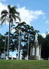
The Shire of Toombul War Memorial was dedicated by the Governor of Queensland, Matthew Nathan, on 12 November 1921. The memorial commemorates who served in World War I. It is located in Nundah Memorial Park (then known as Buckland Park) (27.402890°S 153.058696°E).[45][46]
In November and December 1923, '10 Choice Allotments', were advertised as "Wheeler Estate", to be auctioned by Isles, Love & Co. Limited Auctioneers on 1 December 1923.[47][48][49][50]
This estate was bounded by Sandgate Road to the west, by London Street to the east, and Northgate Road to the north.[51]
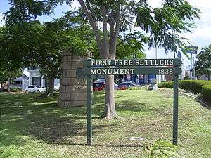
In 1926, George Walker suggested a monument be built to mark the beginnings of Nundah, which was unveiled by the Queensland Governor Sir Leslie Orme Wilson on 23 April 1938 as part of the First Free Settlers' Centenary Celebrations. This First Free Settlers Monument is listed in the Queensland Heritage Register.
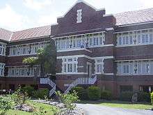
Mount St Joseph's Boarding & Day School for girlds opened in 1953. It was operated by Sisters of St Joseph of the Sacred Heart. In 1964 it was renamed Corpus Christi College.[52] In 2009, it was renamed Mary McKillop College to commemorate the 100th anniversary of her death and her canonisation.[53]
St. George's Mission Hall was dedicated on 11 April 1953 by Archbishop Halse. Its closure on 28 June 1987 was approved by Assistant Bishop Browning.[54]
Decline of Nundah
Nundah's commercial precinct suffered a precipitous decline from the 1970s with the construction of the nearby Westfield Shoppingtown (Later Centro) Toombul shopping centre.[55] Increasing motor traffic along Sandgate Road also reduced Nundah's appeal as a shopping precinct as it was difficult to park. Gradually many shops closed, and those that opened in their place were often "low-class" establishments such as pawn brokers, charity stores etc. that were unappealing to most shoppers, driving them increasingly to shop at Toombul.
Renewal of Nundah
However, in 2001 a road tunnel was constructed under nearby Bage Street, diverting through traffic away from the suburban centre. There was considerable popular support[56] to name the road tunnel after George Bridges in recognition of his contribution to the development of the district and the fact that the tunnel was located on his original land holding. However, the local member Liddy Clark would not support it for fear it would offend the Aboriginal community. In 2009 as part of Queenslands 150th Birthday Celebrations, the Nundah Bypass Tunnel was renamed "George Bridges Tunnel".[57]
In 2008 the Brisbane City Council suburban renewal programme has seen new art installations, cafés and commercial enterprises open in Nundah, creating a village-like atmosphere along the now-quiet Sandgate Road.[58] The suburb has now become popular among white collar workers seeking relatively inexpensive housing and apartments only a moderate distance from the Brisbane CBD. Since then, along with the rest of the city, housing prices in the area have skyrocketed, pricing most of the traditional working class out of the suburb.
In the 2016 census, Nundah had a population of 12,141 people.[1]
Heritage listings
.jpg)
Nundah has a number of heritage-listed sites, including:
- 41 Bage Street: Nundah State School[59]
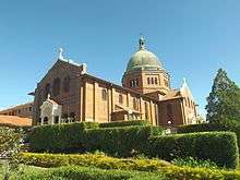
- 136 Buckland Road: Corpus Christi Church[60]
- 88 Hedley Avenue: Nundah Cemetery[61]
- Sandgate Road: First Free Settlers Monument[62]
- Sandgate Road: Nundah Air Raid Shelter[63]
- 1141 Sandgate Road: Toombul Shire Hall[64]
- 35 Surrey Street: Workers' Dwelling No.1[65]
- 7 Union Street: Nundah Fire Station[66]
Demographics
In the 2016 census the population of Nundah was 12,141, 50.5% female and 49.5% male.[1] The median age of the Nundah population was 33 years of age, 5 years below the Australian median. 63.1% of people living in Nundah were born in Australia, compared to the national average of 66.7%; the next most common countries of birth were India 5.9%, New Zealand 4.5%, England 3.2%, Philippines 1.4% and Nepal 1.3%. 72.7% of people spoke only English at home; the next most common languages were Punjabi 2.2%, Hindi 1.6%, Nepali 1.3%, Mandarin 1.3% and Spanish 1.0%.[1]
Transport
Due to its inner-northern location, there are a variety of options for transport within the suburb. Both the Nundah City railway station and the Toombul City railway station are located within the suburb. Both of these railway stations are on both the Caboolture Line and the Shorncliffe railway line, giving both stations 15-minute frequencies throughout the day seven days a week. There are many council bus services that run through the area, including the Great Circle Line.
The Nundah Bypass is a 285-metre-long (935 ft) road tunnel, open to general traffic, that runs underneath the Nundah Village commercial area. Completed in 2001, it provides an alternative route to traffic travelling along Sandgate Road, allowing motorists to avoid the narrow streets of the village area, and reducing traffic congestion for local residents.[67]
Commerce
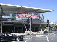
Nundah retails a traditional "shopping strip" commercial district, centred mainly along the section of Sandgate Road that has been bypassed by the Nundah Bypass.[67] There are plenty of cafes and speciality shops, as well as some medical facilities. There is also a small shopping centre anchored by a Woolworths supermarket, which was opened in mid-2007, containing over 200 parking spots, a Subway store, a Coffee Club, and numerous other small shops. There are proposals to relocate the Nundah Library into the Nundah Village district.[68][69] The current Nundah Public Library opened in 1968 and had a major refurbishment in 2016.[70]
Governance
Nundah is in the federal electorate of Lilley.[71] The seat has been held by Wayne Swan of the Australian Labor Party since the 1998 federal election.[71] The suburb lies on the border between the state electorates of Clayfield (held by Liberal Tim Nicholls),[72][73] and Nudgee (held by Labor's Leanne Linard).[74][75] Locally, the suburb is part of the Northgate Ward, held by LNP's Adam Allan.[76]
In earlier times, it was part of the Nundah electorate, one of the historical Electoral districts of Queensland.
Toombul District Cricket Club
The Toombul District Cricket Club is directly across Duke Street from Nundah Train Station. It covers 3.5 hectares, and is bordered by York Street, Duke Street, Melton Road and Jenner Street. The club was founded in 1882, and has been based at Oxenham Park in the heart of Nundah since 1906.
The cricket club provides a family friendly, relaxed atmosphere for local residents to take in a match on Saturdays and Sundays during summer, and enhances the village feel of Nundah by being an exceptionally welcoming club, with full bar and canteen facilities open to locals. In March 2017, Toombul completed renovations to the clubhouse, updating it to become the first rooftop bar in Nundah.
Famous players that have played for Toombul at Oxenham Park over the years include three of Don Bradman's 1948 Invincibles; Bill Brown (cricketer), Don Tallon, and Colin McCool. Others include Jeff Thomson, Ken Mackay, Ron Oxenham, Ryan Harris, Matt Renshaw, Chris Lynn and Wally Grout.
Notable residents
- George Bridges, (1820–1898) pioneer farmer and developer after whom the tunnel was named[57]
- Thomas Bridges (1853–1939) son of George Bridges, Member of the Legislative Assembly
- Bob Bax, legendary coach of The Norths Brisbane first grade rugby league team which is based out of Bishop Park, Nundah and formerly Oxenham Park, Nundah. Bax coached the club to five of their historical six successive premiership victories between 1959 and 1964.
- Elizabeth Grace OAM (born 27 May 1940).OAM Citation: For service to the community of Nundah.
- Bill Knox (1927–2001) Member of the Legislative Assembly, Treasurer of Queensland
- Errold La Frantz MBE (25 May 1919 – 20 February 2015). Oval 2 at Oxenahm Park is named La Frantz Oval in honour of Errold.
- Ken 'Slasher' Mackay Australian test cricketer
- Irene Sweeney (Local Identity), Fanatical supporter of both Nundah-based sports clubs; Toombul District Cricket Club, and Norths Devils Rugby League Club.
- Meta Truscott Australian diarist
An index to people mentioned in the book From Pioneering Days: Nundah Northgate Virginia by Nundah & Districts Historical Society Inc can be found here. While many of the people listed are residents of the district, some people may have had only a peripheral involvement with it.
Landmarks
- Bage Street, named after Freda Bage, first principal of The Women's College, University of Queensland[77]
- Bishop Park – home ground of the Norths Devils rugby league team in the Queensland Cup competition
- Boyd Park – grounds used by the Nundah State School
- Oxenham Park – home of the Toombul District Cricket Club in the Queensland Cricket Association Grade competition, and contains the Ken MacKay and LaFrantz Ovals
- Centro Toombul Shopping Centre
- Nundah Criterium Bicycle Track – in Hedley Avenue/Walkers Way Nundah, next to Albert Bishop Park and the Schultz Canal bikeway
- Nundah Catholic Church
- Nundah Historic Cemetery – contains the graves of many of the original settlers and their families
- Nundah Public Library – adjacent to the Sir William Knox Archives & Resource Centre on Primrose Lane
- Nundah State School – established 1865 as German Station National School
- Nundah Shopping Village
- Nundah Railway Station
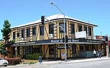
- Prince of Wales Hotel
- Ross Park Skate and BMX Park
- Royal English Hotel
- Schulz Canal
- Sir William Knox Archives & Resource Centre – behind the Nundah Public Library.
- Toombul Railway Station
- Toombul Shire Hall
- Tufnell Home Orphanage – Now the Tufnell Child Care Centre
Parks
- Albert Bishop Park – Amelia Street, Hedley Avenue and Nudgee Road, adjoining Schulz Canal
- Boyd Park – Bage Street and Boyd, Park and Sandgate Roads
- Carew Street – Brook and Carew Streets
- Kalinga Park – Jackson and Kalinga Streets, Park Avenue and Sandgate Road, adjoining Schulz Canal
- Nundah Memorial Park (formerly Buckland Park) – Buckland Road and Bage Street
- Oxenham Park – Duke, Jenner and York Streets and Melton Road
- Plaisted Place – Cavendish, Flower and Maynard Streets
- Ross Park – Parkland Street and Sandgate Road, adjoining Schulz Canal
- Toombul Terrace – Bage, Gardner and Glenhill Streets, Hamson and Toombul Terraces and Royal Avenue
- Upton Street – Upton Street, off London Street
- Wood Street (Road Reserve) – Bage and Wood Streets and Sandgate Road
Education
Nundah State School is a government primary (Prep-6) school for boys and girls at 41 Bage Street (27.4025°S 153.0583°E).[78][79] In 2017, the school had an enrolment of 714 students with 48 teachers (42 full-time equivalent) and 25 non-teaching staff (14 full-time equivalent).[80] It includes a special education program.[78]
Northgate State School in Northgate also provides primary education for children living in eastern Nundah.[81]
St Joseph's School is a Catholic primary (Prep-6) school for boys and girls at 16 Leslie Street (27.4038°S 153.0568°E).[78][82] In 2017, the school had an enrolment of 190 students with 20 teachers (13 full-time equivalent) and 13 non-teaching staff (6 full-time equivalent).[80]
Mary MacKillop College is a Catholic secondary (7-12) school for girls at 60 Bage Street (27.4038°S 153.0584°E).[78][83] In 2017, the school had an enrolment of 524 students with 40 teachers (39 full-time equivalent) and 18 non-teaching staff (15 full-time equivalent).[80] It was formerly known as Corpus Christi College.
There is no government secondary school in Nundah. The nearest government secondary schools are Aviation High in Hendra and Wavell State High School in Wavell Heights.[81]
Help Employment & Training at 1176 Sandgate Road provides training for people with disabilities and assists with finding jobs.[84]
Churches
Since the earliest days of the Zion's Hill mission, there have been a number of churches in the area. The Lutheran church continues to maintain a presence in the suburb, with a number of facilities, including St Paul's church, a childcare centre, and the Zion Retirement home clustered around the area near the corner of Buckland Road and Atthow Parade.
Other denominations also have a presence in the area, including the Catholic Church which has a combined church and girls' school on Bage Street. The Presbyterian, Baptist, Uniting and Anglican churches also have places of worship located within the suburb. Jehovah's Witnesses have a Kingdom Hall in the suburb, which is attended by both the Nundah and Clayfield congregations. Historically, the Methodist church and the Salvation Army also maintained churches in the area, although these are no longer active.
Community services
- Nundah Combined St John Ambulance Division
- Nundah-Northgate Scout Group (Scouts Australia) celebrating centenary in 2009
References
- Australian Bureau of Statistics (27 June 2017). "Nundah (SSC)". 2016 Census QuickStats. Retrieved 20 October 2018.

- "Hamilton Ward". Brisbane City Council. Brisbane City Council. Archived from the original on 12 March 2017. Retrieved 12 March 2017.
- "Northgate Ward". Brisbane City Council. Brisbane City Council. Archived from the original on 12 March 2017. Retrieved 12 March 2017.
- "Nundah - suburb in City of Brisbane (entry 49504)". Queensland Place Names. Queensland Government. Retrieved 26 January 2020.
- Madonna King (31 March 2006). "Local History – Sandgate". ABC Brisbane. abc.net.au. Archived from the original on 7 January 2008. Retrieved 26 January 2008.
- "Bikeway to fill missing link". Northgate Ward. January 2003. Archived from the original on 20 July 2008. Retrieved 26 January 2008.
- "Advertising". The Courier-mail (1159). Queensland, Australia. 19 May 1937. p. 28. Retrieved 5 June 2019 – via National Library of Australia.
- "College Estate, on the heights of nundah". hdl:10462/deriv/264233. Cite journal requires
|journal=(help) - "The North Pine Clan". Pine Rivers State High School. Archived from the original on 19 January 2008. Retrieved 26 January 2008.
- "Historical Events". Nundah and Districts Historical Society. Archived from the original on 27 September 2007. Retrieved 23 June 2007.
- Tilston, John (2005). Meanjin to Brisvegas: Brisbane Comes of Age. p. 94. ISBN 978-1-4116-5216-3.
- These missionaries were:
- Peter Niquet – mason (married)
- August Rode – cabinet-maker (married)
- Johann Leopold Zillmann – blacksmith (married)
- Gottfried Haussmann – farmer (married)
- Wilhelm Hartenstein – weaver (married)
- Carl Franz – tailor
- Gottfried Wagner – shoemaker
- August Olbrecht – shoemaker
- Ludwig Doege – gardener
- Moritz Schneider – medical missionary (married)
- Carl Wilhelm Schmidt – ordained minister
- Christoph Eipper – ordained minister
- Lack, Clem (1959). Triumph in the Tropics: An Historical Sketch of Queensland. Brisbane: Smith & Paterson.
- Jupp, James (2002). The Australian People: An Encyclopedia of the Nation, its People and their Origins. Cambridge University Press. p. 369. ISBN 978-0-521-80789-0.
- "Early History of Nundah". Archived from the original on 31 March 2007. Retrieved 29 January 2007.
- Queensland Family History Society (2010), Queensland schools past and present (Version 1.01 ed.), Queensland Family History Society, ISBN 978-1-921171-26-0
- "The Courier". The Brisbane Courier. XX (2, 391). Queensland, Australia. 27 September 1865. p. 2. Retrieved 12 October 2017 – via National Library of Australia.
- P.R. Skinner (March 2004). "When a little is a Lot: an architect's view" (PDF). Queensland Planner. Archived from the original (PDF) on 9 April 2008. Retrieved 26 January 2008.
- "[COMMUNICATED.] A SCENE IN THE HOUSE". The Brisbane Courier. National Library of Australia. 22 July 1882. p. 7. Retrieved 6 March 2011.
- From Pioneering Days, Nundah, Northgate, Virginia. Nundah & Districts Historical Society Inc, Brisbane. 2002.
- "Origin of Brisbane Suburb Names". Our Indooroopilly. Archived from the original on 29 January 2007. Retrieved 29 January 2007.
- "NOMENCLATURE OF QUEENSLAND—229". The Courier-Mail. Brisbane: National Library of Australia. 24 June 1936. p. 14. Retrieved 9 September 2012.
- "Nundah and Toombul". Northgate Ward. Archived from the original on 28 March 2007. Retrieved 29 January 2007.
- "LOCAL GOVERNMENT". The Brisbane Courier. National Library of Australia. 8 March 1888. p. 5. Retrieved 6 March 2011.
- "Christmas Vacation". The Brisbane Courier. Queensland, Australia. 20 December 1879. p. 5. Retrieved 18 April 2020 – via Trove.
- "Mr Boyd's School at Nundah". The Brisbane Courier. Queensland, Australia. 20 December 1883. p. 3. Retrieved 18 April 2020 – via Trove.
- "The Late A J. Boyd". The Brisbane Courier. Queensland, Australia. 2 June 1928. p. 22. Retrieved 18 April 2020 – via Trove.
- "Classified Advertising". The Brisbane Courier. Queensland, Australia. 17 January 1893. p. 2. Retrieved 18 April 2020 – via Trove.
- "Training of Girls". The Telegraph. Queensland, Australia. 19 June 1893. p. 5. Retrieved 18 April 2020 – via Trove.
- "Home of the Good Shepherd, Nundah". Find and Connect. Archived from the original on 18 April 2020. Retrieved 18 April 2020.
- "Display Advertising". The Queenslander. Queensland, Australia. 5 May 1894. p. 861. Retrieved 18 April 2020 – via Trove.
- "Current News". The Queenslander. Queensland, Australia. 12 May 1894. p. 907. Retrieved 18 April 2020 – via Trove.
- "WOOD PAVING". The Brisbane Courier. Queensland, Australia. 10 July 1897. p. 4. Retrieved 18 April 2020 – via Trove.
- "Educational". The Queenslander. Queensland, Australia. 15 January 1898. p. 124. Retrieved 18 April 2020 – via Trove.
- "Ladies Page". The Telegraph. Queensland, Australia. 8 December 1906. p. 4 (SECOND EDITION). Retrieved 18 April 2020 – via Trove.
- "Our History". St Margaret's Anglican Girls' School. Archived from the original on 16 October 2017. Retrieved 18 April 2020.
- "GOSSIP From Women's Clubland". Queensland Figaro. Queensland, Australia. 19 September 1907. p. 11. Retrieved 18 April 2020 – via Trove.
- "COLLEGE ESTATE AUCTIONED". Sunday Mail. Queensland, Australia. 6 June 1937. p. 10. Retrieved 18 April 2020 – via Trove.
- "Advertising". The Courier-Mail. Queensland, Australia. 5 June 1937. p. 28. Retrieved 18 April 2020 – via Trove.
- "UNWARRANTED TIMIDITY OF ALLOTMENT-BUYERS". The Courier-mail. Queensland, Australia. 8 June 1937. p. 20. Retrieved 18 April 2020 – via Trove.
- "Toombul Shire Hall (Former)". Environmental Protection Agency. Archived from the original on 13 October 2004. Retrieved 28 January 2008.
- "History of Nundah". OurBrisbane. Archived from the original on 22 September 2007. Retrieved 28 January 2008.
- "Early 1900s: The Workers' Dwellings Branch". Department of Housing. Archived from the original on 31 January 2008. Retrieved 28 January 2008.
- Queensland Family History Society (2010), Queensland schools past and present (Version 1.01 ed.), Queensland Family History Society, ISBN 978-1-921171-26-0
- "The Shire of Toombul War Memorial". Monument Australia. Archived from the original on 26 May 2014. Retrieved 25 May 2014.
- "TOOMBUL WAR MEMORIAL". The Queenslander. National Library of Australia. 19 November 1921. p. 18. Retrieved 26 May 2014.
- "Wheeler Estate Advertisement". 17 November 1923. Retrieved 20 May 2020.
- "Wheeler Estate Advertisement". 24 November 1923. Retrieved 20 May 2020.
- "Wheeler Estate Advertisement". 30 November 1923. Retrieved 20 May 2020.
- "Wheeler Estate Advertisement". 1 December 1923. Retrieved 20 May 2020.
- "Wheeler Estate, Nundah". Retrieved 20 May 2020.
- Queensland Family History Society (2010), Queensland schools past and present (Version 1.01 ed.), Queensland Family History Society, ISBN 978-1-921171-26-0
- "Mission and History". Mary McKillop College. Archived from the original on 29 February 2020.
- "Anglican Church South Queensland". Closed Anglican Churches South Queensland. Archived from the original on 3 April 2019. Retrieved 3 April 2019.
- "Chapter Two – 1960 – 1970 – Determination, Drive, and Debentures" (PDF). Westfield Group. Archived from the original (PDF) on 9 April 2008. Retrieved 30 January 2008.
- Letter to Dept of Main Roads from Nundah & Districts Historical Society, 1 May 2001
- Wallace, Craig. "Local pioneer honoured in Q150 celebrations – Thursday, November 19, 2009". Ministerial Media statements. Queensland Government. Archived from the original on 17 March 2011. Retrieved 3 February 2012.
- Kim Flesser. "Another boost to Nundah's renewal". Northgate Ward. Archived from the original on 11 July 2005. Retrieved 30 January 2008.
- "Nundah State School (entry 650033)". Queensland Heritage Register. Queensland Heritage Council. Retrieved 10 February 2018.
- "Corpus Christi Church (entry 601460)". Queensland Heritage Register. Queensland Heritage Council. Retrieved 6 July 2013.
- "Nundah Cemetery (entry 600271)". Queensland Heritage Register. Queensland Heritage Council. Retrieved 6 July 2013.
- "First Free Settlers Monument (entry 601926)". Queensland Heritage Register. Queensland Heritage Council. Retrieved 6 July 2013.
- "Nundah Air Raid Shelter (entry 602484)". Queensland Heritage Register. Queensland Heritage Council. Retrieved 6 July 2013.
- "Toombul Shire Hall (former) (entry 600272)". Queensland Heritage Register. Queensland Heritage Council. Retrieved 6 July 2013.
- "Workers' Dwelling No.1 (entry 600273)". Queensland Heritage Register. Queensland Heritage Council. Retrieved 6 July 2013.
- "Nundah Fire Station (former) (entry 602119)". Queensland Heritage Register. Queensland Heritage Council. Retrieved 6 July 2013.
- "Nundah Bypass". Arup. Archived from the original on 10 November 2007. Retrieved 3 February 2008.
- Flesser, Kim. "Banyo Library, Nundah Library: Speech to Brisbane City Council – Tuesday 17th February 2009" (PDF). Northgate Ward, Brisbane City Council. Archived from the original (PDF) on 18 March 2012. Retrieved 9 September 2012.
- Flesser, Kim. "Toombul/Nundah District Neighbourhood Plan: Edited Speech – Brisbane City Council meeting 7th June 2011" (PDF). Northgate Ward, Brisbane City Council. Archived from the original (PDF) on 18 March 2012. Retrieved 9 September 2012.
- "Nundah Public Library" (PDF). Queensland Public Libraries Statistical Bulletin 2016-2017" (PDF). Public Libraries Connect. November 2017. November 2017. Archived (PDF) from the original on 30 January 2018. Retrieved 22 January 2018.
- "Lilley". Australian Electoral Commission. Archived from the original on 26 January 2008. Retrieved 28 January 2008.
- "Clayfield" (PDF). Queensland Electoral Commission. Archived from the original (PDF) on 9 April 2008. Retrieved 28 January 2008.
- "Tim Nicholls MP". Queensland Coalition. Archived from the original on 7 February 2008. Retrieved 28 January 2008.
- "Nudgee" (PDF). Queensland Electoral Commission. Archived from the original (PDF) on 9 April 2008. Retrieved 28 January 2008.
- "2012 State General Election – Nudgee – District Summary". Electoral Commission Queensland. Archived from the original on 25 April 2013. Retrieved 5 December 2012.
- "Cr Kim Flesser". Brisbane City Council. Retrieved 28 January 2008.
- "NEW STREET NAMES". The Courier-Mail. Brisbane: National Library of Australia. 13 December 1938. p. 3. Retrieved 26 May 2014.
- "State and non-state school details". Queensland Government. 9 July 2018. Archived from the original on 21 November 2018. Retrieved 21 November 2018.
- "Nundah State School". Archived from the original on 12 March 2020. Retrieved 21 November 2018.
- "ACARA School Profile 2017". Archived from the original on 22 November 2018. Retrieved 22 November 2018.
- "Queensland Globe". State of Queensland. Retrieved 18 April 2020.
- "St Joseph's School". Archived from the original on 15 September 2018. Retrieved 21 November 2018.
- "Mary MacKillop College". Archived from the original on 27 February 2015. Retrieved 21 November 2018.
- "Disability Employment Agency". Help Employment & Training. Archived from the original on 26 February 2020. Retrieved 18 April 2020.
External links
| Wikimedia Commons has media related to Nundah, Queensland. |
- "Nundah". Queensland Places. Centre for the Government of Queensland, University of Queensland.
- "Nundah". BRISbites. Brisbane City Council. Archived from the original on 24 July 2008.
- "Nundah". Our Brisbane. Brisbane City Council. Archived from the original on 14 September 2007.
- Nundah Virtual Village
- Nundah suburb information
- Statistical Portrait of Nundah
- A Short History of St. Pauls Lutheran Church, Nundah, Queensland
- Nundah-Northgate Scout Group