Shorncliffe, Queensland
Shorncliffe is a coastal northern suburb of the City of Brisbane, Queensland, Australia on the shore of Bramble Bay, an embayment of Moreton Bay. At the 2016 census, the suburb recorded a population of 1,870.[1] The suburb has historically been an attraction within Brisbane due to its historic Shorncliffe pier, and Lovers Walk, a walking path along the coastline between Shorncliffe and neighbouring Sandgate.
| Shorncliffe Brisbane, Queensland | |||||||||||||||
|---|---|---|---|---|---|---|---|---|---|---|---|---|---|---|---|
.jpg) Shorncliffe pier in the evening | |||||||||||||||
| Population | 1,870 (2016 census)[1] | ||||||||||||||
| • Density | 1,900/km2 (4,800/sq mi) | ||||||||||||||
| Postcode(s) | 4017 | ||||||||||||||
| Area | 1 km2 (0.4 sq mi) | ||||||||||||||
| Location | 19 km (12 mi) from Brisbane | ||||||||||||||
| LGA(s) | City of Brisbane (Deagon Ward)[2] | ||||||||||||||
| State electorate(s) | Sandgate | ||||||||||||||
| Federal Division(s) | Lilley | ||||||||||||||
| |||||||||||||||
Geography
Shorncliffe is situated in Brisbane's northeastern suburbs on Moreton Bay and is the neighbouring suburb of Sandgate. The suburb comes under the jurisdiction of the Brisbane City Council.
History

Aboriginal people called the area Warra, meaning an expanse of water.[3]

In December 1879, allotments in the Town of Sandgate were auctioned by John Cameron.[4][5] A map advertising the auction shows allotments bordered by Friday, Yundah and Kate Streets, now in Shorncliffe. A map advertising the auction states the land available was subdivisions 1 to 14, of allotments 8, 9, 10 and part of 7, Sec. 3, Town of Sandgate.[6]
The Sandgate Golf Club commenced in 1921 with the official opening of its 9-hole course on 25 November 1922, having obtained a 21-year lease of the site from the Sandgate Town Council for a nominal rental as the Council believed that the golf course would be of lasting benefit.[7][8][9]
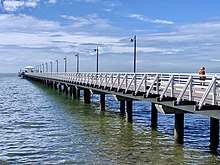
In March 2012, the Shorncliffe pier was closed off to the public by the council due to fears of structural failure. It was rebuilt and reopened in April 2016.[10]
Attractions

Shorncliffe is a popular Brisbane destination due to its coastline, the historical Shorncliffe pier, which is one of the longest recreational piers in Australia, Lovers Walk, a walking track along the coastline between Shorncliffe and neighbouring Sandgate as well as Moora Park and Beach, which includes a dog off-leash beach.
Heritage listings
Shorncliffe has a number of heritage-listed sites, including:
- 8 Allpass Parade: Musgrave House[11]
- 20 Wharf Street: former Drew Residence[12]
- 154 Shorncliffe Parade: Saltwood[13]
Facilities
Shorncliffe includes one primary schools; Shorncliffe State School and one private boys school; St Patrick's College. Both these schools are situated on neighbouring blocks of land to each other.
Shorncliffe also includes one railway station, which is the terminus of the Shorncliffe railway line.
The Sandgate Golf Club is located in Allpass Parade.[14]
The Sandgate sub-branch of the Queensland Country Women's Association meets at the Volunteer Marine Rescue Centre at 95 Allpass Parade.[15]
Events
At times Shorncliffe has different festivals, including The Blue Water Festival whereby that start of the Brisbane to Gladstone yacht race begins from the opening of The Cabbage Tree Creek.
Demographics
In the 2011 census, the population of Shorncliffe was 1,914, 49.3% female and 50.7% male.
The median age of the Shorncliffe population was 41 years, 4 years above the Australian median.
78% of people living in Shorncliffe were born in Australia, compared to the national average of 69.8%; the next most common countries of birth were England 5.6%, New Zealand 5%, Scotland 0.8%, United States of America 0.7%, Ireland 0.7%.
92.4% of people spoke only English at home; the next most common languages were 0.8% German, 0.5% French, 0.4% Japanese, 0.3% Dutch, 0.3% Serbian.
At the 2016 census, the suburb recorded a population of 1,870.[1]
Gallery
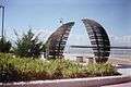 Shorncliffe
 Shorncliffe
 Shorncliffe
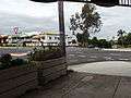 A main street in Shorncliffe
 New Shorncliffe Pier
References
- Australian Bureau of Statistics (27 June 2017). "Shorncliffe (State Suburb)". 2016 Census QuickStats. Retrieved 29 March 2018.

- "Deagon Ward". Brisbane City Council. Brisbane City Council. Retrieved 12 March 2017.
- Gregory, Helen; Dianne Mclay (2010). Building Brisbane's History: Structure, Sculptures, Stories and Secrets. Warriewood, New South Wales: Woodslane Press. p. 150. ISBN 9781921606199.
- "Classified Advertising". The Brisbane Courier. XXXIV (3, 901). Queensland, Australia. 18 November 1879. p. 4. Retrieved 29 October 2019 – via National Library of Australia.
- "ABSTRACT OF SALES BY AUCTION THIS DAY". The Brisbane Courier. XXXV (3, 912). Queensland, Australia. 1 December 1879. p. 2. Retrieved 29 October 2019 – via National Library of Australia.
- "Plan of subdivisions 1 to 14, of allotments 8, 9, 10 and part of 7, Sec. 3, town of Sandgate". 1879. hdl:10462/deriv/459792. Cite journal requires
|journal=(help) - "Sandgate Golf Club". Retrieved 23 October 2014.
- "GOLF". The Brisbane Courier. National Library of Australia. 11 November 1922. p. 17. Retrieved 23 October 2014.
- "GOLF". The Brisbane Courier. National Library of Australia. 18 November 1922. p. 17. Retrieved 23 October 2014.
- Johnston, Bill (5 April 2016). "Shorncliffe Pier opens with glaring spelling error". Quest Community Newspapers. Retrieved 9 April 2016.
- "Musgrave House (entry 601499)". Queensland Heritage Register. Queensland Heritage Council. Retrieved 6 July 2013.
- "Drew Residence (former) (entry 602024)". Queensland Heritage Register. Queensland Heritage Council. Retrieved 6 July 2013.
- "Saltwood (entry 600291)". Queensland Heritage Register. Queensland Heritage Council. Retrieved 6 July 2013.
- "Contact Us". Sandgate Golf Club. Retrieved 23 October 2014.
- "Branch Locations". Queensland Country Women's Association. Retrieved 26 December 2018.
External links
- University of Queensland: Queensland Places: Shorncliffe
- "Shorncliffe". BRISbites. Brisbane City Council. Archived from the original on 23 July 2008.
- "Shorncliffe". Our Brisbane. Brisbane City Council. Archived from the original on 7 September 2007.