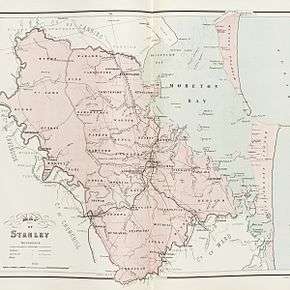
County of Stanley, Queensland

The County of Stanley is a cadastral division centred on the city of Brisbane in Queensland, Australia, that is used mainly for the purpose of registering land titles. It was named after Edward Stanley, who was three times British prime minister in the 1850s and 1860s.[1] It is bounded by the Logan River in the south, the Brisbane River at what is now Lake Wivenhoe in the west, the Stanley River at what is now Lake Somerset in the north-west, and Caboolture River in the north. It includes Moreton Island and Stradbroke Island, and extends west to Ipswich's CBD, south to Loganlea and north to Morayfield.

Stanley
Queensland
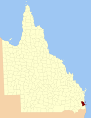
Location within Queensland
Lands administrative divisions around Stanley:
Cavendish Canning Pacific Ocean
Churchill Stanley Pacific Ocean
Churchill Ward Pacific Ocean
Map of Stanley county in 1886

History

Stanley was formerly a county in New South Wales between the establishment of Brisbane in 1826, and the formation of Queensland as a separate colony in 1859, and was officially established by proclamation on 27 February 1843. It was generally understood (though only somewhat formally defined) to include the land between the 27th and 28th parallels of latitude, Moreton Bay and the western ranges, covering an area of 1,724 square miles (4,470 km2).[2] In 1852 it had a population of 2,000. Wheat, coffee, cotton and tobacco were described as being important crops. By 1863, the county had contracted to its present boundaries.

On 7 March 1901, the Governor of Queensland proclaimed new boundaries under the Land Act 1897,[3] and Stanley was described as follows:

Bounded on the south by the county of Ward; on the west by the western boundaries of the parishes of Undullah, Ipswich and Chuwar to the Brisbane River, by that river and the Stanley River upwards to Oaky Creek, by that creek upwards to the west boundary of the parish of Byron [...] by the north boundaries of the parishes of Pine, Caboolture and Burpengary; and on the east by the Pacific Ocean,—including Moreton and Stradbroke Islands.

Parishes

Stanley is divided into parishes, listed as follows:

ParishLGACoordinatesTowns/localities
BulimbaBrisbane27°29′S 153°04′EBulimba, Carina, Coorparoo, Greenslopes
BundambaIpswich27°42′S 152°50′ERedbank Plains
BunyaMoreton Bay27°22′S 152°56′EAlbany Creek, Everton Park, Ferny Hills
BurnettSomerset27°23′S 152°40′E
BurpengaryMoreton Bay27°08′S 152°59′EBurpengary
ByronSomerset27°04′S 152°41′EMount Mee
CabooltureMoreton Bay27°07′S 152°52′ECaboolture South, Morayfield
CapalabaRedland27°32′S 153°11′EAlexandra Hills, Birkdale, Capalaba, Wellington Point
ChuwarIpswich27°34′S 152°48′EKaralee, North Ipswich, Tivoli
ClevelandRedland27°32′S 153°18′ECleveland, Victoria Point
DixonSomerset27°12′S 152°33′E
DundasSomerset27°19′S 152°41′E
EnoggeraBrisbane27°25′S 152°56′EEnoggera, Keperra, Ferny Grove, St Johns Wood, Windsor, Ashgrove
GoodnaIpswich27°37′S 152°51′EBundamba, Goodna, Redbank
IndooroopillyBrisbane27°30′S 152°59′EIndooroopilly, St Lucia, Kenmore
IpswichIpswich27°39′S 152°47′EIpswich, Booval, Raceview
KedronBrisbane27°22′S 153°00′EAspley, Chermside, Kedron, Stafford
KholoBrisbane27°29′S 152°48′EKarana Downs
MackenzieLogan27°40′S 153°07′ECornubia, Loganlea, Slacks Creek, Shailer Park
MacleanScenic Rim27°47′S 152°57′EMaclean
MinjerribaRedland27°39′S 153°26′ENorth Stradbroke Island
MitchellLogan27°40′S 153°00′EBrowns Plains, Park Ridge
MoggillBrisbane27°31′S 152°52′EMoggill, Pullenvale
NoogoonBrisbane27°23′S 153°14′E
North BrisbaneBrisbane27°27′S 153°02′EBrisbane CBD, New Farm, Toowong
North BrookSomerset27°18′S 152°35′E
NundahBrisbane27°19′S 153°03′EBracken Ridge, Brighton, Sandgate, Deagon
OxleyBrisbane27°34′S 152°56′EInala, Jindalee, Oxley, Sherwood, Middle Park
ParkerMoreton Bay27°21′S 152°48′ECloseburn, Mount Glorious
PerryScenic Rim27°44′S 153°00′EPark Ridge South
PineMoreton Bay27°07′S 152°47′EOcean View
RedcliffeMoreton Bay27°14′S 153°03′EKallangur, Petrie, Redcliffe
RedlandRedland27°37′S 153°15′ECarbrook, Mount Cotton, Redland Bay
RussellRedland27°38′S 153°22′ERussell Island
SahlSomerset27°25′S 152°44′E
SamfordMoreton Bay27°23′S 152°51′ESamford, Mount Nebo
SamsonvaleMoreton Bay27°14′S 152°47′EDayboro
South BrisbaneBrisbane27°29′S 153°00′ESouth Brisbane, Woolloongabba
St JohnSomerset27°12′S 152°40′E
StapyltonIpswich27°42′S 152°55′ECamira, Springfield, Greenbank
StradbrokeRedland27°28′S 153°27′ENorth Stradbroke Island
TiffinBrisbane27°15′S 153°25′EMoreton Island
TingalpaBrisbane27°30′S 153°08′ECarindale, Manly, Tingalpa, Wynnum, Rochedale,
ToombulBrisbane27°23′S 153°06′EHamilton, Nudgee, Nundah, Pinkenba, Clayfield, Albion, Eagle Farm, Hendra
UndullahScenic Rim27°49′S 152°52′E
WararbaMoreton Bay27°02′S 152°51′EWamuran
WarnerMoreton Bay27°19′S 152°56′EStrathpine, Lawnton
WhitesideMoreton Bay27°13′S 152°53′EWhiteside
WoogarooLogan27°38′S 152°57′EForest Lake
YeerongpillyBrisbane27°36′S 153°4′EAcacia Ridge, Coopers Plains, Calamvale

See also

References

  1. "Stanley - county (entry 32180)". Queensland Place Names. Queensland Government. Retrieved 21 June 2017.
  2. "DOMESTIC INTELLIGENCE". The Moreton Bay Courier. National Library of Australia. 16 October 1852. p. 2. Retrieved 19 June 2013.
  3. "A Proclamation". Queensland Government Gazette. 75. 8 March 1901. pp. 967–980.
This article is issued from Wikipedia. The text is licensed under Creative Commons - Attribution - Sharealike. Additional terms may apply for the media files.