Brighton, Queensland
Brighton is a coastal suburb and the northernmost suburb of City of Brisbane, Queensland, Australia,[3] located 19 kilometres (12 mi) north of the Brisbane CBD. The Nashville neighbourhood makes up much of the southwest of the suburb. The suburb had a population of 9,479 in 2016, according to the Australian Census.[1] Brighton has mostly suburban housing.
| Brighton Brisbane, Queensland | |||||||||||||||
|---|---|---|---|---|---|---|---|---|---|---|---|---|---|---|---|
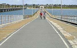 Hornibrook Bridge towards Brighton, 2007 | |||||||||||||||
| Population | 9,479 (2016 census)[1] | ||||||||||||||
| • Density | 1,374/km2 (3,558/sq mi) | ||||||||||||||
| Postcode(s) | 4017 | ||||||||||||||
| Area | 6.9 km2 (2.7 sq mi) | ||||||||||||||
| Location | 19 km (12 mi) from Brisbane CBD | ||||||||||||||
| LGA(s) | City of Brisbane (Deagon Ward)[2] | ||||||||||||||
| State electorate(s) | Sandgate | ||||||||||||||
| Federal Division(s) | Lilley | ||||||||||||||
| |||||||||||||||

Brighton was the site of the Second World War barracks of the RAAF Air Training School between December 1940 and May 1946; it was built on reclaimed land. It later became Eventide, a large nursing home run by the Queensland Government. More than 700 patients were transferred from Dunwich on North Stradbroke Island to the facility.[4] It was announced in late 2012 that the nursing home would close because it was uneconomic to ensure that the aging buildings complied with building codes.
Demographics
In the 2011 census, Brighton recorded a population of 9,012 people, 51.1% female and 48.9% male.
The median age of the Brighton population was 40 years of age, 3 years above the Australian median.
78.4% of people living in Brighton were born in Australia, compared to the national average of 69.8%; the next most common countries of birth were England 5.3%, New Zealand 4.3%, Scotland 0.8%, Philippines 0.6%, Ireland 0.5%.
91.4% of people spoke only English at home; the next most popular languages were 0.5% German, 0.3% French, 0.3% Italian, 0.2% Tagalog, 0.2% Cantonese.
History
The main pub in Brighton is the Brighton Hotel located along Beaconsfield Terrace. An early settler, Captain William Townsend, bought the Brighton Hotel and used it as his home and, once sold in 1893, it was used as an orphanage. It resumed being a hotel in 1912.[5][6]
Education
Three primary schools are located within Brighton: Brighton State School, Nashville State School and St. Kieran's Primary School. Brighton State School opened on 27 January 1920[7] and Nashville State School opened on 25 January 1960.[7] Autism Queensland also has a centre located in Brighton.
Brighton Wetlands
Brighton has a woodland wetland protected by the local government. This natural reserve is made up of three woods; namely Goodenia Woods, Pimelea Woods and Dianella Woods. The land is so called a wetland as it fills with water during heavy rain which flows into a small tidal creek, Copold Creek, that flows under one of the main roads of Brighton, Beaconsfield Terrace, and then leads to Bramble Bay between 15th and 16th Avenues.
Brighton Esplanade

Brighton is a desirable Brisbane suburb due to both the ease of public transport, such as the train service from nearby Sandgate, and also the bayside esplanade. This peaceful parkland esplanade follows the coast between the Houghton Highway bridge and Sandgate. The esplanade is used by walkers, cyclists and families. Brighton's beach is used by kite surfers and also walkers during low tide. The road that follows the esplanade is called Flinders Parade named after the navigator Captain Matthew Flinders who was the first European to discover the area in order to establish a penal colony for Lord Brisbane, Governor of New South Wales.
Bridges
Since 1935, one or more of three adjacently positioned bridges have connected Brisbane to Redcliffe Peninsula between Brighton at their southern end and Clontarf on the peninsula at their northern end. The first of these to be built, the Hornibrook Bridge, has since been demolished upon completion of the Ted Smout Memorial Bridge in 2010, which now stands alongside the Houghton Highway, which opened in 1979.
Heritage listings
Brighton has a number of heritage-listed sites, including:
- Hornibrook Highway: Hornibrook Bridge (mostly demolished in 2011)[8]
Amenities
Brighton is serviced by a fortnightly visit of the Brisbane City Council's mobile library service in the car park at Decker Park on 25th Avenue.[9]
References
- Australian Bureau of Statistics (27 June 2017). "Brighton (QLD) (State Suburb)". 2016 Census QuickStats. Retrieved 29 March 2018.

- "Deagon Ward". Brisbane City Council. Brisbane City Council. Archived from the original on 9 March 2017. Retrieved 12 March 2017.
- "Brighton (entry 41701)". Queensland Place Names. Queensland Government. Retrieved 22 September 2015.
- "Eventide to lose residential aged care". Northside Chronicle. Quest Newspapers. 18 October 2012. Retrieved 30 December 2012.
- "Brighton". blogs.slq.qld.gov.au. Archived from the original on 22 December 2015. Retrieved 11 December 2015.
- "Local History - Brighton". www.abc.net.au. Archived from the original on 25 December 2015. Retrieved 11 December 2015.
- "Opening and closing dates of Queensland Schools". Queensland Government. Retrieved 18 April 2019.
- "Hornibrook Highway Bridge (entry 601246)". Queensland Heritage Register. Queensland Heritage Council. Retrieved 11 July 2013.
- "Mobile library services". Brisbane City Council. Archived from the original on 6 June 2014. Retrieved 3 June 2014.
Further reading
- Stevens, E. V. (Eric Vaughan), 1878-1960 (1 January 1956), Early Brighton and Sandgate, Royal Historical Society of Queensland, retrieved 12 December 2015CS1 maint: uses authors parameter (link) — full text available online
External links
| Wikimedia Commons has media related to Brighton, Queensland. |
- University of Queensland: Queensland Places: Brighton
- "Brighton". BRISbites. Brisbane City Council. Archived from the original on 20 July 2008.
- "Brighton". Our Brisbane. Brisbane City Council. Archived from the original on 30 September 2007.