Pinkenba, Queensland
Pinkenba is a coastal eastern suburb of the City of Brisbane, Queensland, Australia.[3] In the 2016 census, Pinkenba had a population of 368 people.[1]
| Pinkenba Brisbane, Queensland | |||||||||||||||
|---|---|---|---|---|---|---|---|---|---|---|---|---|---|---|---|
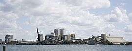 Bulwer Island, 2010 | |||||||||||||||
 Pinkenba | |||||||||||||||
| Coordinates | 27.4058°S 153.1408°E | ||||||||||||||
| Population | 368 (2016 census)[1] | ||||||||||||||
| • Density | 20.22/km2 (52.37/sq mi) | ||||||||||||||
| Postcode(s) | 4008 | ||||||||||||||
| Area | 18.2 km2 (7.0 sq mi) | ||||||||||||||
| Time zone | AEST (UTC+10:00) | ||||||||||||||
| Location | 11.1 km (7 mi) ENE of Brisbane GPO | ||||||||||||||
| LGA(s) | City of Brisbane (Hamilton Ward)[2] | ||||||||||||||
| State electorate(s) | Clayfield | ||||||||||||||
| Federal Division(s) | Lilley | ||||||||||||||
| |||||||||||||||
Geography
Pinkenba is on the northern side of the Brisbane River, 10 kilometres (6.2 mi) from the Brisbane central business district facing Moreton Bay. The area is spatially isolated from other residential suburbs and is surrounded by the Brisbane Airport to the north and west, and industrial land and the bank of the Brisbane River to the south.
The neighbourhood of Myrtletown is located (27.3919°S 153.1336°E) in the northern end of the suburb of Pinkenba.[4]
The former suburb and now neighbourbood of Meeandah is located (27.4297°S 153.1069°E) in the southern end of the suburb of Pinkenba.[5][6]
History

The name Pinkenba comes from the Turrbal word binkinba which means "place of land tortoise".[7]
The former suburb of Meeandah took its name from the now disused Meeandah railway station on the Pinkenbah railway line, which in turn is named after a corruption of the Greek word meander and refers to Serpentine Creek which flowed through the area (but has subsequently been converted into a drain due to the development of Brisbane Airport). The name is often thought to be an Aboriginal word.[8][9][10]
Boggy Creek State School opened on 22 February 1875. It was renamed Myrtle State School in 1888. In 1900 it was renamed Pinkenba State School.[11] It closed on 31 December 2010.[12] It was located at 248 Eagle Farm Road on the corner of Serpentine Road (27.4202°S 153.1218°E).[13][14][15][16]
On 15 October 1892 there was an auction of crown land near a new meatworks.
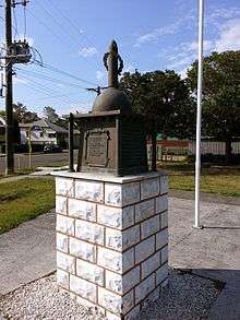
Pinkenba Wharf was the point of embarkation for many World War I soldiers. The Pinkenba & District War Memorial commemorates those from the district who served and died in the war. The memorial was unveiled on 16 August 1919 by the Queensland Governor, Sir Hamilton Goold-Adams.[17][18] Qantas selected Pinkenba for its flying boat base in the 1930s. Until the war, Hamilton Reach was too congested, however the base eventually moved upstream providing better access for passengers.[19]

Myrtletown State School opened on 1924 and closed on 19 February 1971. It occupied the northern part of the block bounded by Main Beach Road, School Road (now Lewandowski Drive) and Sandmere Street (27.3893°S 153.1412°E).[11][13]
On 6 March 1963, Queen Elizabeth II unveiled a roadside memorial which commemorates the discovery of commercial quantities of oil in Australia.[20] Although significant oil deposits had been found at Moonie the pipeline to Brisbane was not completed until the following year. The site was selected because it was close to a large oil refinery which was to process the oil.[20]
In 1975 Myrtletown (then an independent suburb) was downgraded to a neighbourhood within Pinkenba.[4] Myrtletown was historically known as a residential and farming locality, though Myrtletown has become industrial and portside in recent decades.
Pinkenba recorded a population of 350 people at the 2011 census.[21]
As at March 2020, there are two cruise ship wharves for Brisbane, with differing facilities. Portside Wharf at Hamilton was completed in 2006 and is an international standard facility for cruise liners, offering restaurants, coffee shops, gift shops, and other facilities. However, due to the height restrictions of the Gateway Bridge and length restriction of 270 metres (890 ft) that far upstream, the larger ocean-going cruise liners must dock further down the river at the more industrial Multi User Terminal at the Port of Brisbane. In late 2020 the new Brisbane International Cruise Terminal will open on the northern bank of the Brisbane River in the suburb of Pinkenba opposite the port (27.3811°S 153.1542°E). The new cruise terminal is located at Luggage Point next to the Luggage Point Sewage Treatment Plant (which has been renamed the Luggage Point Resource Recovery Centre). The new terminal will be able to accommodate the largest cruise vessels in the world. It will be operated by the port but will not be part of the suburb of Port of Brisbane.[22]
Demographics
In the 2011 census, Pinkenba recorded a population of 350 people; 42.9% female and 57.1% male. The median age of the Pinkenba population was 42 years, 5 years above the Australian median. Children aged under 15 years made up 15.4% of the population and people aged 65 years and over made up 12.8% of the population. 62.5% of people living in Pinkenba were born in Australia, compared to the national average of 69.8%; the next most common countries of birth were New Zealand 7%, Iran 6.8%, England 2.5%, Italy 1.4%, France 0.8%. 77.3% of people spoke only English at home; the next most popular languages were 2% Italian, 1.7% Cantonese, 1.1% Tagalog, 0.9% Afrikaans, 0.9% Serbo-Croatian/Yugoslavian. The most common religious affiliation was "No Religion" 22.8%; the next most common responses were Catholic 19.9%, Anglican 16.5%, Presbyterian and Reformed 5.4% and Uniting Church 4.3%.[21]
Transport
The suburb is accessed by road via Kingsford Smith Drive which passes an industrial area before reaching the suburb. Pinkenba is also the site of the now-abandoned Pinkenba railway station. The station opened in 1882 and closed in 1993. The branch line to Pinkenba was constructed so as to encourage port development downstream away from the Brisbane central business district.[23]
In Pinkenba, on the day of the 2011 census, 9.1% of employed people traveled to work on public transport and 63.6% by car (either as driver or as passenger).[21]
Industry
BP's Bulwer Island Refinery and Shell's Pinkenba Terminal are located in Pinkenba. In 2011, Shells operations at Bulwer Island were expanded with the opening of a new bitumen and marine fuel import facility.[24] Shell facilities include their Queensland state office, a bitumen plant, a lubricants and grease manufacturing facility, several warehouses and fuel storage unit.[25]
Heritage listings
Pinkenba has a number of heritage-listed sites, including:
- Eagle Farm Road: Pinkenba War Memorial[26]
- Myrtletown Reserve: RAN Station 9, Pinkenba[27]
Amenities
Pinkenba has a historical trail which was designed on behalf of the Pinkenba Community Association and the Port of Brisbane with help from Brisbane City Council Neighbourhood planning team; more work is still to be done over the next ten years with the beautification of Pinkenba with the start being the local park and historical path and local pub.
Numerous development projects have been proposed for the area, including residential developments and an immigration detention centre, but nothing has progressed. The suburb contains a small number of detached houses (primarily of weatherboard construction), local store, pub and industrial precincts.
See also
References
- Australian Bureau of Statistics (27 June 2017). "Pinkenba (SSC)". 2016 Census QuickStats. Retrieved 20 October 2018.

- "Hamilton Ward". Brisbane City Council. Brisbane City Council. Archived from the original on 12 March 2017. Retrieved 12 March 2017.
- "Pinkenba - suburb in City of Brisbane (entry 47580)". Queensland Place Names. Queensland Government. Retrieved 28 November 2019.
- "Myrtletown - neighboroughood in the City of Brisbane (entry 23746)". Queensland Place Names. Queensland Government. Retrieved 2 January 2020.
- Universal street directory for Brisbane City and suburbs (1st ed.), Universal Business Directories (Aust.) Pty. Ltd, 1955
- "Meeandah - unbounded locality in City of Brisbane (entry 21502)". Queensland Place Names. Queensland Government. Retrieved 29 March 2020.
- "South-East Queensland Placenames" (PDF). State Library of Queensland. Archived from the original (PDF) on 29 October 2014.
- "Meeandah - railway station in the City of Brisbane (entry 21503)". Queensland Place Names. Queensland Government. Retrieved 29 March 2020.
- "Serpentine Creek - watercourse in City of Brisbane (entry 30420)". Queensland Place Names. Queensland Government. Retrieved 29 March 2020.
- "SKETCHER". The Queenslander. Queensland, Australia. 11 April 1914. p. 8. Retrieved 29 March 2020 – via Trove.
- Queensland Family History Society (2010), Queensland schools past and present (Version 1.01 ed.), Queensland Family History Society, ISBN 978-1-921171-26-0
- "Opening and closing dates of Queensland Schools". Queensland Government. Retrieved 30 December 2019.
- "Cadastral map of Queensland Twenty Chain (1:15840) series sheet 2532 displaying real property information; majority of road names and Administrative Areas including Parish and County". Queensland Government. 1959. Retrieved 2 January 2020.
- "Home page". Pinkenba State School. 18 July 2008. Archived from the original on 18 July 2008. Retrieved 10 March 2020.
- "PINKENBA SCHOOL HAS JUBILEE". Daily Standard. Queensland, Australia. 26 September 1927. p. 2 (3 p.m. EDITION). Retrieved 11 March 2020 – via Trove.
- Chiclcott, Tanya; Vlasic, Kimberley (7 June 2013). "Full school asssets sale list". The Courier-Mail. Retrieved 30 October 2019.
- "Pinkenba & District War Memorial". Monument Australia. Archived from the original on 7 April 2014. Retrieved 5 April 2014.
- "PINKENBA SOLDIERS' MEMORIAL". The Brisbane Courier. National Library of Australia. 18 August 1919. p. 7. Retrieved 6 April 2014.
- Jones, David (2007). Wings on the River. Boolarong Press. pp. 31, 42. ISBN 978-1921054273. Archived from the original on 25 March 2018. Retrieved 3 January 2013.
- Gregory, Helen; Dianne Mclay (2010). Building Brisbane's History: Structure, Sculptures, Stories and Secrets. Warriewood, New South Wales: Woodslane Press. p. 108. ISBN 9781921606199.
- Australian Bureau of Statistics (31 October 2012). "Pinkenba (State Suburb)". 2011 Census QuickStats. Retrieved 3 January 2013.
- "Brisbane International Cruise Terminal". Port of Brisbane. Archived from the original on 4 January 2020. Retrieved 4 January 2020.
- Laverty, John Robert (2009). The Making of a Metropolis: Brisbane 1823–1925. Boolarong Press. p. 73. ISBN 978-0975179352. Archived from the original on 25 March 2018. Retrieved 3 January 2013.
- "Major addition to BP's Queensland infrastructure officially opened by the Hon Craig Wallace". Press Release. BP. 15 December 2011. Archived from the original on 21 August 2012. Retrieved 3 January 2013.
- "Shell Pinkenba Terminal". Shell Australia. Archived from the original on 22 January 2013. Retrieved 3 January 2013.
- "Pinkenba War Memorial (entry 602453)". Queensland Heritage Register. Queensland Heritage Council. Retrieved 6 July 2013.
- "RAN Station 9, Pinkenba (Myrtletown) (entry 602448)". Queensland Heritage Register. Queensland Heritage Council. Retrieved 6 July 2013.
Further reading
- Prior, S. G (1983), Eagle Farm, Pinkenba, Myrtletown, 1983
External links
| Wikimedia Commons has media related to Pinkenba, Queensland. |
- University of Queensland: Queensland Places:Pinkenba
- "Pinkenba". BRISbites. Brisbane City Council. Archived from the original on 24 July 2008.
- "Pinkenba". Our Brisbane. Brisbane City Council. Archived from the original on 14 September 2007.