Shire of Bulloo
The Shire of Bulloo /ˈbʊluː/ BUUL-oo is a local government area in South West Queensland, Australia. Cameron Corner, the point where New South Wales, Queensland and South Australia meet, is located at the south west corner of the shire. The Bulloo Shire covers an area of 73,724 square kilometres (28,465 sq mi), and its administrative centre is the town of Thargomindah.
| Shire of Bulloo Queensland | |||||||||||||||
|---|---|---|---|---|---|---|---|---|---|---|---|---|---|---|---|
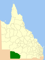 Location in Queensland | |||||||||||||||
| Population | 330 (2018)[1] | ||||||||||||||
| • Density | 0.00448/km2 (0.01159/sq mi) | ||||||||||||||
| Established | 1880 | ||||||||||||||
| Area | 73,724 km2 (28,465.0 sq mi)[1] | ||||||||||||||
| Mayor | John Ferguson | ||||||||||||||
| Council seat | Thargomindah | ||||||||||||||
| State electorate(s) | Warrego | ||||||||||||||
| Federal Division(s) | Maranoa | ||||||||||||||
| Website | Shire of Bulloo | ||||||||||||||
| |||||||||||||||
Major industries in the shire include wool, beef, opals, oil and natural gas.
History
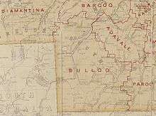
Paroo Division was established on 11 November 1879 as one of the original divisions proclaimed under the Divisional Boards Act 1879.[2][3] On 3 June 1880, the western part of the Paroo Division was separated to create the Bulloo Division.[4]
On 21 June 1883, the boundaries between Diamantina Division and Bulloo Division were adjusted. [5][6]
With the passage of the Local Authorities Act 1902, Bulloo Division became the Shire of Bulloo on 31 March 1903.[7]
On 17 July 1930 Shire of Bulloo was abolished and absorbed into Shire of Quilpie, but was re-instated on 4 July 1931.[7]
Towns and localities
The Shire of Bulloo includes the following towns and localities:
- Thargomindah
- Bullawarra
- Bulloo Downs
- Cameron Corner
- Durham
- Dynevor
- Hungerford
- Noccundra
- Nockatunga
- Norley
- Oontoo
Amenities
Bulloo Shire Council operates a public library in Thargomindah.[8]
Chairmen and mayors
Population
| Year | Population |
|---|---|
| 1933 | 614 |
| 1947 | 540 |
| 1954 | 672 |
| 1961 | 772 |
| 1966 | 658 |
| 1971 | 575 |
| 1976 | 521 |
| 1981 | 492 |
| 1986 | 675 |
| 1991 | 799 |
| 1996 | 801 |
| 2001 | 724 |
| 2006 | 370 |
| 2011 | 403 |
| 2016 | 353 |
References
- "3218.0 – Regional Population Growth, Australia, 2017-18: Population Estimates by Local Government Area (ASGS 2018), 2017 to 2018". Australian Bureau of Statistics. Australian Bureau of Statistics. 27 March 2019. Retrieved 25 October 2019. Estimated resident population, 30 June 2018.
- "Proclamation [Paroo Division]". Queensland Government Gazette. 11 November 1879. p. 25:1000.
- "Agency ID1472, Paroo Divisional Board". Queensland State Archives. Retrieved 21 September 2013.
- "Proclamation [Bulloo Division]". Queensland Government Gazette. 5 June 1880. p. 26:1316.
- "Proclamation [Diamantina Division amended]". Queensland Government Gazette. 23 June 1883. p. 32:1631.
- "Proclamation [Bulloo Division amended]". Queensland Government Gazette. 23 June 1883. p. 32:1632.
- "Agency ID9651, Bulloo Shire Council". Queensland State Archives. Retrieved 26 September 2013.
- "Bulloo Shire Council". Public Libraries Connect. State Library of Queensland. 20 September 2016. Archived from the original on 6 February 2018. Retrieved 6 February 2018.
- Pugh, Theophilus Parsons (1927). Pugh's Almanac for 1927. Retrieved 13 June 2014.
- "2008 Bulloo Shire - Mayoral Election - Election Summary". Electoral Commission of Queensland. 31 August 2010. Retrieved 16 March 2017.
- "2012 Bulloo Shire - Mayoral Election - Election Summary". Electoral Commission of Queensland. 28 May 2012. Retrieved 16 March 2017.
- "Your Councillors". Bulloo Shire Council. Bulloo Shire Council. Archived from the original on 14 June 2014. Retrieved 14 June 2014.
- "2016 Bulloo Shire Council - Mayoral Election - Election Summary". Electoral Commission of Queensland. 19 April 2016. Retrieved 16 March 2017.
- "2020 Local Government Elections: Saturday, 28 March 2020". Electoral Commission of Queensland. 2020. Archived from the original on 16 June 2020. Retrieved 16 June 2020.