Hamilton, Queensland
Hamilton is an affluent suburb in the Inner North East area of the City of Brisbane, Queensland, Australia.[3] Hamilton is located along the north bank of the Brisbane River.[4] The neighbourhood is hilly with views of the Brisbane central business district.
| Hamilton Brisbane, Queensland | |||||||||||||||
|---|---|---|---|---|---|---|---|---|---|---|---|---|---|---|---|
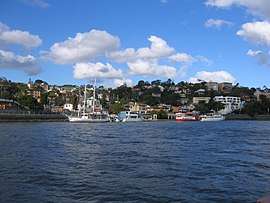 Southern part of Hamilton facing the Brisbane River | |||||||||||||||
| Population | 6,995 (2016 census)[1] | ||||||||||||||
| • Density | 4,110/km2 (10,660/sq mi) | ||||||||||||||
| Postcode(s) | 4007 | ||||||||||||||
| Area | 1.7 km2 (0.7 sq mi) | ||||||||||||||
| Location | 7 km (4 mi) from Brisbane | ||||||||||||||
| LGA(s) | City of Brisbane (Hamilton Ward)[2] | ||||||||||||||
| State electorate(s) | Clayfield | ||||||||||||||
| Federal Division(s) | Brisbane | ||||||||||||||
| |||||||||||||||
In 2013, the suburb had the highest mean taxable income of any in Queensland.[5]
History
.jpg)
It is believed the first hotel in the district was built by the Gustavus Hamilton (father of Messrs. F. G. Hamilton, barrister, and R. Hamilton, surveyor). Amongst the earlier lessees of the hotel was a Mrs. Warren, who, by coincidence, married another Mr. Hamilton, so that the hotel was occupied by different families of the name Hamilton. The Hamilton Hotel became an easy reference mark in the days when buildings were few in the district, and its name was gradually applied to the whole district.[3][6]
In Brisbane's early history, Hamilton was the home to many aristocrats and clergy. This suburb is known for being an "old wealth" suburb compared to "new wealth" suburbs in Brisbane such as Paddington, Toowong and Indooroopilly. A number of Brisbane's iconic mansions are found in Hamilton, mainly because the exclusive suburb has views of the central business district and other surrounding suburbs.
This district was the birthplace of Charles Kingsford Smith in 1897.
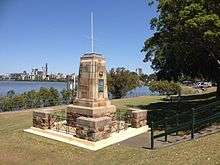
After World War I, a war memorial was built alongside the Brisbane River. It was unveiled by the Queensland Governor John Goodwin on Sunday 16 August 1931.[7]

During World War II an accident occurred involving a Corsair fighter plane. It had been unloaded from a ship in the river, had its wings folded up and was being towed along Kingsford Smith Drive by a truck when it snagged the tramway overhead and brought them down.
The Hamilton Library opened in 1947.[8]
In 1967 the Mission to Seafarers opened the Anglican Chapel of St. Nicolas in Hamilton. It was dedicated by Coadjutor Bishop Hudson on 4 November 1967, and closed by Bishop A.O.Charles on 17 June 2007.[9]
In recent times, a cruise ship terminal has been built in a precinct at Portside Wharf; this precinct has then seen substantial commercial and residential development.
Heritage listings
.jpg)
Hamilton has a number of heritage-listed sites, including:
- 28 Annie Street: Toorak House[10]
- 6 Hillside Crescent: Lochiel[11]
- 16 Hillside Crescent: Marie Ville/Eltham [12]
- 194 Kingsford Smith Drive: El Nido[13]
- 240 Kingsford Smith Drive: Greystaines[14]
- 1 Lexington Terrace: Woolahra[15]
- 34 Mullens Street: Cremorne[16]
- 9 Queens Road: Palma Rosa[17]
- 36–42 Racecourse Road: Hamilton Town Hall[18]
Demographics
In the 2011 census the population of Hamilton was 4,721, 50.4% female and 49.6% male.
The median/average age of the Hamilton population is 39 years of age, 2 years above the Australian average.
70.6% of people living in Hamilton were born in Australia. The other top responses for country of birth were New Zealand 4.4%, England 3.2%, India 1.4%, United States of America 1.1%, Ireland 1%.
83.3% of people speak English as their first language 1.3% Italian, 1.3% Mandarin, 0.9% Cantonese, 0.6% Japanese, 0.6% Greek.
Services
The Brisbane City Council operates a public library in Hamilton on the corner of Racecourse Road and Rossiter Parade.[19]
Transport
CityCat stops are Bretts Wharf and, since October 2011,[20] Northshore Hamilton. Hamilton is serviced by Brisbane Transport bus routes 300, 301, 302, 303, 305.
Northshore Hamilton
The development of the Northshore Hamilton project was announced on 27 March 2008 by the Urban Land Development Authority.[21] A concept master plan for Northshore Hamilton was released by Premier Anna Bligh in September 2008.[21] The development covers 304 hectares and is expected to house 13,000 new residents.[21] It includes two kilometres of river frontage which will be open to the public.
References
- Australian Bureau of Statistics (27 June 2017). "Hamilton (State Suburb)". 2016 Census QuickStats. Retrieved 2 December 2017.

- "Hamilton Ward". Brisbane City Council. Brisbane City Council. Retrieved 12 March 2017.
- "Hamilton (entry 49441)". Queensland Place Names. Queensland Government. Retrieved 1 January 2015.
- Universal Business Directories (Aust.) Pty. Ltd (1997), Brisbane : includes Gold Coast & Sunshine Coast : 1997 (41st ed.), UBD, ISBN 978-0-7319-0886-8
- Alistair Walsh (2 May 2013). "Hamilton tops Queensland's highest earning postcodes with list dominated by coal mining towns". Property Observer. Private Media. Retrieved 26 August 2013.
- "Brisbane's Suburban Beauties". The Brisbane Courier (1864–1933). Queensland: National Library of Australia. 29 September 1906. p. 12. Retrieved 1 January 2015.
- "Hamilton War Memorial". The Brisbane Courier (1864–1933). Queensland: National Library of Australia. 14 August 1931. p. 9. Retrieved 3 April 2014.
- "Public Libraries Statistical Bulletin 2016-17" (PDF). Public Libraries Connect. State Library of Queensland. November 2017. p. 11. Retrieved 15 January 2018.
- "Closed Churches - Anglican Records and Archives Centre". Archived from the original on 3 April 2019. Retrieved 3 April 2019.
- "Toorak House (entry 600216)". Queensland Heritage Register. Queensland Heritage Council. Retrieved 6 July 2013.
- "Lochiel (entry 601965)". Queensland Heritage Register. Queensland Heritage Council. Retrieved 6 July 2013.
- Brisbane Heritage Register entry for Marie Ville, 16 Hillside Crescent, Hamilton
- "El Nido (entry 602390)". Queensland Heritage Register. Queensland Heritage Council. Retrieved 6 July 2013.
- "Greystaines (entry 602551)". Queensland Heritage Register. Queensland Heritage Council. Retrieved 6 July 2013.
- "Woolahra (entry 600217)". Queensland Heritage Register. Queensland Heritage Council. Retrieved 6 July 2013.
- "Cremorne (entry 600218)". Queensland Heritage Register. Queensland Heritage Council. Retrieved 6 July 2013.
- "Palma Rosa (entry 600219)". Queensland Heritage Register. Queensland Heritage Council. Retrieved 6 July 2013.
- "Hamilton Town Hall (entry 602444)". Queensland Heritage Register. Queensland Heritage Council. Retrieved 6 July 2013.
- "Hamilton Library". Public Libraries Connect. State Library of Queensland. 15 December 2017. Retrieved 15 January 2018.
- Tony Moore (19 November 2011). "Car sharing solution for Kingsford Smith Drive gridlock". Brisbane Times. Fairfax Media. Retrieved 19 November 2011.
- "Q2 Vision for Northshore Hamilton released". Media release. Urband Development Land Authority. 14 September 2008. Retrieved 19 November 2011.
External links
| Wikimedia Commons has media related to Hamilton, Queensland. |
- Hamilton profile, Brisbane City Council
- University of Queensland: Queensland Places: Hamilton
- "Hamilton". BRISbites. Brisbane City Council. Archived from the original on 20 July 2008.
- "Hamilton". Our Brisbane. Brisbane City Council. Archived from the original on 31 December 2007.
- Hamilton, suburb info