Alderley, Queensland
Alderley is a northern suburb of the City of Brisbane, Queensland, Australia.[4] Alderley is ranked #1 as Brisbane’s most liveable suburb according to a 2019 study by Deliotte and Tract which compared 260 Brisbane suburbs.
| Alderley Brisbane, Queensland | |||||||||||||||
|---|---|---|---|---|---|---|---|---|---|---|---|---|---|---|---|
 The Alderley Hotel | |||||||||||||||
| Population | 6,117 (2016 census)[1] | ||||||||||||||
| • Density | 2,450/km2 (6,340/sq mi) | ||||||||||||||
| Established | 1878 | ||||||||||||||
| Postcode(s) | 4051 | ||||||||||||||
| Area | 2.5 km2 (1.0 sq mi) | ||||||||||||||
| Location | 7 km (4 mi) from Brisbane CBD | ||||||||||||||
| LGA(s) | City of Brisbane (Enoggera Ward;[2] Marchant Ward)[3] | ||||||||||||||
| State electorate(s) | |||||||||||||||
| Federal Division(s) | Brisbane | ||||||||||||||
| |||||||||||||||
Geography
Alderley is 7 kilometres (4 mi) north-west of the Brisbane CBD. It is surrounded by Newmarket in the south, Ashgrove and Enoggera in the west, Grange and Stafford in the east and Kedron and Everton Park in the north. At the 2006 census, it had a population of 5,068.
Alderley has several warehouses, a police station and a community-based shopping complex that includes a Coles supermarket and Liquorland bottleshop.
History

In prehistory, the area was inhabited by the Turrbal Aboriginal clan. Corroborees were held at Sedgeley Park estate.
The name Alderley derives from Alderley Edge in Cheshire, England.[4] Alderley is an older suburb, having had a post office since 1878 and a railway station since 1899.
On Saturday 19 April 1890 auctioneers G. T. Bell offered 296 residential lots (mostly 16 perches) in Alderley Park Estate on Hall Street, Alderley Street and Wakefield Street with South Pine Road to the west. The estate was diagonally opposite the Alderley Arms Hotel. At the time of sale, the Ferny Grove railway line had not yet been built however the proposed railway route line is marked on the land sale advertisement. Hall Street now terminates at the Alderley railway station instead of continuing through to South Pine Road as it was in 1890.[5][6] At the auction, only 51 of the 296 lots were sold for an average price of £28/8/8 for a total of £1450.[7]
On Saturday 14 March 1914 auctioneers Isles, Love & Co offered 86 residential lots (mostly 16 perches) in the Green Hills Estate bounded by Lloyd Street to the north, Cole Street to the east and both sides of Elfreda Street.[8][9]
On Saturday 29 October 1921 auctioneers Blocksidge & Ferguson offered 232 residential allotments of 18 and 22 perches in the Smyth's Hill Estate bounded by Longsight Street to the north, Raymont Road to the south, Longsight Street to the west and Mornington Street to the east.[10][11] (Mornington Street does not exist in this far south due to the subsequent development of Alderley Grove Park.)[12]
On Saturday 17 June 1922 auctioneers Cameron Bros offered 53 residential sites of mostly 16 perches in Hall Street, Alderley Avenue and Wakefield Streets.[13][14]
On Saturday 2 October 1937 auctioneers Isles, Love & Co offered 26 residential sites ranging from 24 to 31 perches in Section 2 of the Manwaring Estate on Goskar Avenue and Banks Road.[15][16]
Trams operated by the Brisbane City Council ran to the suburb between 1949 and 1968.
In the 2011 census, Alderley recorded a population of 5,679 people, 51.1% female and 48.9% male.[17]
Heritage listings
Alderley has a number of heritage-listed sites, including:
- 16 Quarry Road: Strathearn[18]
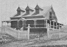
- 39 David Street: Farrington House[19]
- 117 Mina Parade: Newmarket Brickworks Chimney[20]
Demographics
In the 2011 census, Alderley recorded a population of 5,679 people, 51.1% female and 48.9% male.[17] The median age of the Alderley population was 33 years, 4 years below the national median of 37. 78.5% of people living in Alderley were born in Australia, compared to the national average of 69.8%; the next most common countries of birth were England 3.1%, New Zealand 2.7%, India 1.1%, Nepal 0.9%, South Africa 0.6%. 88.4% of people spoke only English at home; the next most popular languages were 1% Nepali, 0.8% Italian, 0.7% Spanish, 0.6% Korean, 0.5% Cantonese.[17]
References
- Australian Bureau of Statistics (27 June 2017). "Alderley". 2016 Census QuickStats. Retrieved 24 October 2013.

- "Enoggera Ward". Brisbane City Council. Brisbane City Council. Archived from the original on 5 March 2017. Retrieved 12 March 2017.
- "Marchant Ward". Brisbane City Council. Brisbane City Council. Archived from the original on 12 March 2017. Retrieved 12 March 2017.
- "Alderley (entry 44135)". Queensland Place Names. Queensland Government. Retrieved 15 March 2014.
- "Alderley Park". 1890. hdl:10462/deriv/280195. Cite journal requires
|journal=(help) - "Advertising". Brisbane (5, 464). Queensland, Australia. 18 April 1890. p. 8. Retrieved 27 August 2019 – via National Library of Australia.
- "COMMERCIAL". The Brisbane Courier. XLVI (10, 067). Queensland, Australia. 21 April 1890. p. 3. Retrieved 27 August 2019 – via National Library of Australia.
- "The Green Hill Estate". 1914. hdl:10462/deriv/280196. Cite journal requires
|journal=(help) - "Advertising". Daily Standard (390). Queensland, Australia. 14 March 1914. p. 8 (SECOND EDITION). Retrieved 27 August 2019 – via National Library of Australia.
- "Smyths Hill Estate, Alderley". 1921. hdl:10462/comp/2884. Cite journal requires
|journal=(help) - "Advertising". The Brisbane Courier (19, 898). Queensland, Australia. 29 October 1921. p. 10. Retrieved 27 August 2019 – via National Library of Australia.
- Google (27 August 2019). "Alderley Grove Park" (Map). Google Maps. Google. Retrieved 27 August 2019.
- "Alderley : choice sites in the Bay View & Alderley Heights Estates". 1922. hdl:10462/deriv/420916. Cite journal requires
|journal=(help) - "Advertising". Daily Standard (2948). Queensland, Australia. 16 June 1922. p. 8. Retrieved 27 August 2019 – via National Library of Australia.
- "Manwaring Estate, Section 2: Alderley". 1937. hdl:10462/deriv/252817. Cite journal requires
|journal=(help) - "Advertising". The Courier-mail (1276). Queensland, Australia. 2 October 1937. p. 24. Retrieved 27 August 2019 – via National Library of Australia.
- Australian Bureau of Statistics (31 October 2012). "Alderley". 2011 Census QuickStats. Retrieved 24 October 2013.
- "Strathearn (entry 602064)". Queensland Heritage Register. Queensland Heritage Council. Retrieved 6 July 2013.
- "Farrington House (entry 600046)". Queensland Heritage Register. Queensland Heritage Council. Retrieved 6 July 2013.
- "Newmarket Brickworks Chimney (entry 601357)". Queensland Heritage Register. Queensland Heritage Council. Retrieved 6 July 2013.
Sources
- http://www.brisbanecity.com.au/alderley Archived 7 May 2019 at the Wayback Machine
- http://queenslandplaces.com.au/alderley Archived 7 March 2011 at the Wayback Machine
- Savills - "Brisbane's Rich History"
External links
| Wikimedia Commons has media related to Alderley, Queensland. |
- University of Queensland: Queensland Places: Alderley
- "Alderley". BRISbites. Brisbane City Council. Archived from the original on 20 July 2008.
- "Alderley". Our Brisbane. Brisbane City Council. Archived from the original on 6 March 2008.
- Alderley Theatre This image is held by the State Library of Queensland image number 20340