Myrtletown, Queensland
Myrtletown is a former town and now industrial neighbourhood within the suburb of Pinkenba, City of Brisbane, Queensland, Australia.[1]
_northeast_of_Brisbane%2C_1889.jpg)
Geography
In the north of Pinkenba, it is situated near the northern bank of the mouth of the Brisbane River. The north-eastern most point of Myrtletown at the mouth of the Brisbane River is Luggage Point (also called Uniacke Point) at (27.3781°S 153.1597°E).[2]
Boggy Creek enters the Brisbane River at 27.3956°S 153.1403°E.[3]
History
The area was originally known as Boggy Creek after the creek of the same name. The name Myrtletown derives from a prominent grove of myrtle trees, which had disappeared by 1928.[4]
Luggage Point was named Uniacke Point by John Oxley during his exploration of the Brisbane River in the HM Colonial Cutter Mermaid in December 1823. The point was named after John Fitzgerald Uniacke (1798-1825) who was naturalist and ornithologist on the expedition.[2][5] However, by 1839, it is known both as Luggage Point and Uniacke Point.[6] The name Luggage Point derives from the practice of off-loading luggage at the point to enable ships to cross the bar at the mouth of the Brisbane River (no longer present due to dredging). The luggage would be transferred up river separately.
Initially used only for fishing and gathering oysters, John Chapman established a farm in the area circa 1881. By 1928 it had developed within a town centre surrounded by about 200 acres (81 ha) of farmland, with approximately 250 people were living in the area. Many of the residents were descended from the early settler families of Chapman, Allnut, Wenzel and Naumann. The farming consisted of orchards, banana plantations, vineyards (growing Black Hamburg grapes) and market gardens (growing tomatoes, beans, cabbages and cauliflowers). Prawns and fish were obtained from Boggy Creek.[4]
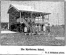
Residents began lobbying for a local school in 1922.[7] Myrtletown State School opened on 1924 and closed on 19 February 1971. It occupied the northern part of the block bounded by Main Beach Road, School Road (now Lewandowski Drive) and Sandmere Street (27.3893°S 153.1412°E).[8][9][10][11]
As at 1928, the town had a Methodist church but no post office. There were 3 or 4 omnibus services to Brisbane each day.[4]
Brisbane's sewerage treatment plant was located at Luggage Point (and continues in that location to the present day) and was serviced by a tramway.[4]
Formerly a semi-rural residential area, the construction of the Brisbane Airport at nearby Cribb Island caused most residents to leave. The area has become increasingly industrial ever since
As at March 2020, there are two cruise ship wharves for Brisbane, with differing facilities. Portside Wharf at Hamilton was completed in 2006 and is an international standard facility for cruise liners, offering restaurants, coffee shops, gift shops, and other facilities. However, due to the height restrictions of the Gateway Bridge and length restriction of 270 metres (890 ft) that far upstream, the larger ocean-going cruise liners must dock further down the river at the more industrial Multi User Terminal at the Port of Brisbane. In late 2020 the new Brisbane International Cruise Terminal will open on the northern bank of the Brisbane River in the suburb of Pinkenba opposite the port (27.3811°S 153.1542°E). The new cruise terminal is located at Luggage Point next to the Luggage Point Sewage Treatment Plant (which has been renamed the Luggage Point Resource Recovery Centre). The new terminal will be able to accommodate the largest cruise vessels in the world. It will be operated by the port but will not be part of the suburb of Port of Brisbane.[12]
References
| Wikimedia Commons has media related to Myrtletown, Queensland. |
- "Myrtletown - neighbourhood in Pinkenba in the City of Brisbane (entry 23746)". Queensland Place Names. Queensland Government. Retrieved 10 March 2020.
- "Luggage Point - point in City of Brisbane (entry 20250)". Queensland Place Names. Queensland Government. Retrieved 10 March 2020.
- "Boggy Creek - watercourse in the City of Brisbane (entry 3458)". Queensland Place Names. Queensland Government. Retrieved 10 March 2020.
- "FERTILE MYRTLETOWN". The Brisbane Courier. Queensland, Australia. 18 August 1928. p. 11. Retrieved 11 March 2020 – via Trove.
- Steele, John Gladstone (1970), Pamphlet, Uniacke and Field (PDF), retrieved 11 March 2020
- Dixon, Robert (26 June 1839). Survey of the Brisbane River (M10761).
- "MYRTLETOWN WANTS SCHOOL". Daily Standard. Queensland, Australia. 14 October 1922. p. 10. Retrieved 11 March 2020 – via Trove.
- Queensland Family History Society (2010), Queensland schools past and present (Version 1.01 ed.), Queensland Family History Society, ISBN 978-1-921171-26-0
- "Cadastral map of Queensland Twenty Chain (1:15840) series sheet 2532 displaying real property information; majority of road names and Administrative Areas including Parish and County". Queensland Government. 1959. Retrieved 2 January 2020.
- "Cadastral map of Queensland Twenty Chain (1:15840) series sheet 2532 displaying real property information; majority of road names and Administrative Areas including Parish and County". Queensland Government. 1959. Retrieved 2 January 2020.
- Opening and Closing Dates of Queensland Schools, Education Queensland, retrieved May 19, 2007
- "Brisbane International Cruise Terminal". Port of Brisbane. Archived from the original on 4 January 2020. Retrieved 4 January 2020.