Central Bethlehem Historic District
Central Bethlehem Historic District is a national historic district located at Bethlehem, Lehigh County and Northampton County, Pennsylvania. The district includes 165 contributing buildings, 6 contributing sites (including Nisky Hill Cemetery), 9 contributing structures, and 4 contributing objects. It is primarily residential, but also includes commercial buildings along Main Street. Most of the buildings were built between the mid-18th to early-20th century. The buildings are primarily 2 1/2 stories tall and constructed of brick or stone. More recent residences are frame construction. The district encompasses building that reflect Bethlehem's development from a Moravian community, 1741-1844, to an industrial based economy, 1845-1938. Notable non-residential buildings include several communal Moravian buildings, the George H. Myers Building, and the Hill to Hill Bridge. Located in the district is the separately listed Lehigh Canal.[2][3]
Central Bethlehem Historic District | |
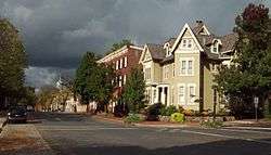 West Church Street, Central Bethlehem Historic District, October 2011 | |
  | |
| Location | Bounded by Main, Nevada, and East Broad Streets, and the Lehigh River, Bethlehem, Pennsylvania |
|---|---|
| Coordinates | 40°37′6″N 75°22′56″W |
| Area | 132.3 acres (53.5 ha) |
| Architectural style | Late 19th And 20th Century Revivals, Late Victorian, Gothic Revival |
| NRHP reference No. | 72001131, 88000452 (Boundary Increase)[1] |
| Added to NRHP | May 5, 1972; November 7, 1988 (Boundary Increase) |
It was added to the National Register of Historic Places in 1972, with a Boundary Increase in 1988.[1]
References
- "National Register Information System". National Register of Historic Places. National Park Service. July 9, 2010.
- "National Historic Landmarks & National Register of Historic Places in Pennsylvania" (Searchable database). CRGIS: Cultural Resources Geographic Information System. Note: This includes Pennsylvania Register of Historic Sites and Landmarks (October 1971). "National Register of Historic Places Inventory Nomination Form: Central Bethlehem Historic District" (PDF). Retrieved 2011-10-29. and "Part two of Nomination Form" (PDF).
- "National Historic Landmarks & National Register of Historic Places in Pennsylvania" (Searchable database). CRGIS: Cultural Resources Geographic Information System. Note: This includes James G. Whildon, Jr. and William Sisson (1988). "National Register of Historic Places Inventory Nomination Form: Central Bethlehem Historic District (Boundary Increase)" (PDF). Retrieved 2011-10-29.
| Wikimedia Commons has media related to Central Bethlehem Historic District. |
| Topics |  | |
|---|---|---|
| Lists by county |
| |
| Lists by city |
| |
| Other lists | ||
| ||