Vaishali district
Vaishali district is a district in Bihar, India. It is a part of Tirhut division.[1]
Vaishali district | |
|---|---|
District of Bihar | |
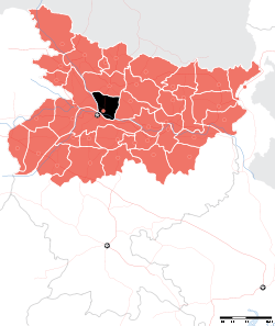 Location of Vaishali district in Bihar | |
| Country | India |
| State | Bihar |
| Division | Tirhut |
| Headquarters | Hajipur |
| Government | |
| • Lok Sabha constituencies | Hajipur, Vaishali |
| • Vidhan Sabha constituencies | Hajipur, Lalganj, Vaishali, Mahua, Raja Pakar, Raghopur, Mahnar, Patepur |
| Area | |
| • Total | 2,036 km2 (786 sq mi) |
| Population (2011) | |
| • Total | 3,495,021(68th rank in India 640 district) |
| Demographics | |
| • Literacy | 66.60 per cent |
| • Sex ratio | 895 |
| Languages | |
| • Official Language(s) | Vajjika, Hindi, English |
| Time zone | UTC+05:30 (IST) |
| Major highways | NH 19, NH 77, NH 103 |
| Website | vaishali |
History
| Historical population | ||
|---|---|---|
| Year | Pop. | ±% p.a. |
| 1901 | 737,793 | — |
| 1911 | 761,720 | +0.32% |
| 1921 | 737,475 | −0.32% |
| 1931 | 787,287 | +0.66% |
| 1941 | 868,565 | +0.99% |
| 1951 | 942,472 | +0.82% |
| 1961 | 1,133,086 | +1.86% |
| 1971 | 1,348,990 | +1.76% |
| 1981 | 1,662,527 | +2.11% |
| 1991 | 2,146,065 | +2.59% |
| 2001 | 2,718,421 | +2.39% |
| 2011 | 3,495,021 | +2.54% |
| source:[2] | ||
Ancient Vaishali
Vaishali derives its name from King Vishal. Even before the advent of Buddhism and Jainism, Vaishali was the capital of the vibrant Vajji confederation, since before the birth of Mahavira (c. 599 BC), which suggests that it was the first republic in the world, similar to those later found in ancient Greece.[3] In that period, Vaishali was an ancient metropolis and the capital city of the republic of the Vajji confederation of Mithila, which covered most of the Himalayan Gangetic region of present-day Bihar. Very little is known about the early history of Vaishali. The Vishnu Purana records 34 monarchs of Vaishali, the first being Nabhaga, who is believed to have abdicated his throne over a matter of human rights and believed to have declared: "I am now a free tiller of the soil, king over my acre." The last among the 34 was Sumati, who is considered a contemporary of Dasharatha, father of the Hindu god, Rama.
Post-Independence
Vaishali became a district when it was split from Muzaffarpur in 1972.[4]
Geography
Vaishali district occupies an area of 2,036 square kilometres (786 sq mi),[5]
Economy
In 2006 the Ministry of Panchayati Raj named Vaishali one of the country's 250 most backward districts (out of a total of 640).[6] It is one of the 38 districts in Bihar currently receiving funds from the Backward Regions Grant Fund Programme (BRGF).[6]
Demographics
According to the 2011 census Vaishali district has a population of 3,495,021,[7] roughly equal to the nation of opurPanama[8] or the US state of Connecticut.[9] This gives it a ranking of 86th in India (out of a total of 640).[7] The district has a population density of 1,717 inhabitants per square kilometre (4,450/sq mi) .[7] Its population growth rate over the decade 2001-2011 was 28.58%.[7] Vaishali has a sex ratio of 892 females for every 1000 males,[7] and a literacy rate of 66.60%.[7]
At the time of the 2011 Census of India, 95.09% of the population in the district spoke Maithili and 4.80% Urdu as their first language.[10]
Flora and fauna
In 1997 Vaishali district became home to the Barela Salim Ali Zubba Saheni Wildlife Sanctuary, which has an area of 2 km2 (0.8 sq mi).[11]
See also
References
- http://tirhut-muzaffarpur.bih.nic.in Archived 2015-03-16 at the Wayback Machine
- Decadal Variation In Population Since 1901
- "Archived copy". Archived from the original on 2008-12-23. Retrieved 2008-12-01.CS1 maint: archived copy as title (link)
- Law, Gwillim (2011-09-25). "Districts of India". Statoids. Archived from the original on 2011-10-17. Retrieved 2011-10-11.
- Srivastava, Dayawanti et al. (ed.) (2010). "States and Union Territories: Bihar: Government". India 2010: A Reference Annual (54th ed.). New Delhi, India: Additional Director General, Publications Division, Ministry of Information and Broadcasting (India), Government of India. pp. 1118–1119. ISBN 978-81-230-1617-7.CS1 maint: extra text: authors list (link)
- Ministry of Panchayati Raj (September 8, 2009). "A Note on the Backward Regions Grant Fund Programme" (PDF). National Institute of Rural Development. Archived from the original (PDF) on April 5, 2012. Retrieved September 27, 2011.
- "District Census 2011". Census2011.co.in. 2011. Archived from the original on 2011-06-11. Retrieved 2011-09-30.
- US Directorate of Intelligence. "Country Comparison:Population". Archived from the original on 27 September 2011. Retrieved 2011-10-01.
Panama 3,460,462 July 2011 est.
- "2010 Resident Population Data". U. S. Census Bureau. Archived from the original on 2013-10-19. Retrieved 2011-09-30.
Connecticut 3,574,097
- 2011 Census of India, Population By Mother Tongue
- Indian Ministry of Forests and Environment. "Protected areas: Bihar". Archived from the original on August 23, 2011. Retrieved September 25, 2011.
External links
- Vaishali district, Official website
- Vaishali district at Govt. of Bihar, website.
- Official Website of Tirhut Division
Places adjacent to Vaishali district | ||||||||||
|---|---|---|---|---|---|---|---|---|---|---|
| ||||||||||
Railways in Bihar | |||||||||||
|---|---|---|---|---|---|---|---|---|---|---|---|
| Network Lines Sections |
| ||||||||||
| Rail Bridges |
| ||||||||||
| |||||||||||
| State symbols | |
|---|---|
| History |
|
| Administration |
|
| Overviews | |
| Divisions and districts | |
| Cities | |
| Municipal Corporation |
|
| Poltics | |
| Culture |
|