Arrah
Arrah is a city and a municipal corporation in Bhojpur district in the Indian state of Bihar. The name is also sometimes transliterated as Ara.[2] It is the district headquarters of Bhojpur district, located near the confluence of the Ganges and Sone rivers, some 24 miles from Danapur and 36 miles from Patna.[3]
Arrah Ara Zila | |
|---|---|
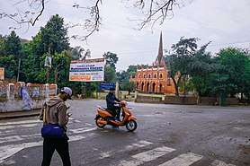
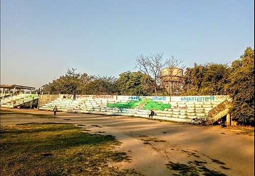
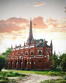
From top, left to right: Ramna Road , Collect-orate Pond, Veer Kunwar Singh Stadium, Arrah–Chhapra Bridge, Holy Saviour Church, Ramna Maidan, Civil Court Road | |
 Arrah Location in Bihar, India | |
| Coordinates: 25°33′27″N 84°40′12″E | |
| Country | India |
| State | Bihar |
| District | Bhojpur |
| Named for | Aaranya Devi Temple |
| Government | |
| • Type | Municipal Corporation |
| • Body | Arrah Municipal Corporation |
| • MP | Raj Kumar Singh (BJP) |
| Area | |
| • Metro | 49 km2 (18.919 sq mi) |
| Population (2011) | |
| • City | 261,430[1] |
| Languages | |
| • Official | Bhojpuri, Hindi, Urdu, English |
| Time zone | UTC+5:30 (IST) |
| PIN | 802301, 802302 & 802312 |
| Telephone code | +91-6182 |
| Vehicle registration | BR-03 |

.jpg)
Etymology
According to a Jain inscription found in Masarh village near the town, Arrah is mentioned there as Aramnagar. So probably Arrah is derived from Aramnagar.[4][5][6]
According to mythologies, the word "Arrah" or "Ara" is derived from the Sanskrit word Aranya, which means forest. It suggests that the entire area around modern Ara was heavily forested in the old days. According to mythology, sage Vishwamitra, the Guru of Rama, had his 'Ashram' somewhere in this region. Rama killed the demon Taraka somewhere near Arrah.[7][8]
History
Ancient
Arrah has mentions in Ramayana, According to mythology, sage Vishwamitra, the Guru of RAMA, had his 'Ashram' somewhere in this region, Rama killed the demon Taraka somewhere near Arrah.[7][8]
In ancient India, it was the part of Magadha. In 684BC Arrah was the part of the region ruled by Haryanka dynasty. During Chandragupta Maurya Arrah was the part of the great Magadh empire. The Pillars of Ashoka are found at the Masarh village in Arrah town. During 200 CE it was part of Gupta dynasty. Bhojpuri Folktales of Vikramaditya like Singhashan Battishi, Baital pachisi are still famous in the town and other Bhojpuri speaking area. It was also the part of Pala Empire and Chero empire. Bihiya and Tirawan were the capitals of Chief Ghughulia and Raja Sitaram Rai respectively.
Medieval
In 14th century Chero lost the Western Bihar along with Arrah to Ujjainiya Rajputs under the leadership of Hunkar Shahi.[9] They named the tertiary "Bhojpur" on the name of their ancestor Raja Bhoj.In 1607, a number of Chero chief combined to launch a spirited attack against Ujjaniniyas. One of the descendants of Sitaram Rai, Kumkum Chand Jharap drove out Ujjainiyas from Bhojpur region and capture major parts of territory.[10] In 1611, Ujjainiyas defeated Cheros and again recaptured the lost region. Sher Shah Suri also defeated Chero during the early 16 century and made Sasaram its capital after defeating the Mughals. In 1604 Chieftain Narayan Mal got a land grant from Jahangir after that Raja Horil Singh shifted the capital to Dumrao and established Dumraon Raj.
Modern
After Battle of Buxar British took control over Arrah. Arrah was one of the centre of revolt of 1857.
During the Indian rebellion of 1857, a group of 18 British civilians and 50 Indian soldiers was besieged in the Little House at Arrah, by a band of 2500–3000 armed soldiers and around 8000 others under the command of 80-year-old Veer Kunwar Singh, the Zamindar of adjacent Jagdishpur. A British regiment, despatched to their assistance from Danapur, was repulsed,[11] but the group withstood the siege for eight days until relieved by other East India Company troops.[12]
Geography
Arrah is located at the elevation of 192 m from the sea level at the bank of Son river, Ganga River and Gangi River.[13] Arrah lies at the confluence of the Ganga and the Son river, other small rivers that flow in the town are Gangi River, Badki Nadi and Chhotki Nadi.
During the British Raj Arrah was the part of Bengal presidency. The land of the city is fertile and most used for cultivation with very low forest cover. The main crops that are grown here are rice, mango and mahuaa.
Climate
The climate is characterised by relatively high temperatures and evenly distributed precipitation throughout the year. The Köppen Climate Classification sub-type for this climate is "Cfa" (Humid Subtropical Climate).[14]
| Climate data for Arrah | |||||||||||||
|---|---|---|---|---|---|---|---|---|---|---|---|---|---|
| Month | Jan | Feb | Mar | Apr | May | Jun | Jul | Aug | Sep | Oct | Nov | Dec | Year |
| Average high °C (°F) | 23 (73) |
26 (78) |
32 (90) |
37 (99) |
38 (100) |
36 (96) |
33 (91) |
32 (89) |
32 (90) |
32 (89) |
28 (82) |
24 (75) |
31 (88) |
| Average low °C (°F) | 11 (51) |
13 (55) |
18 (64) |
23 (74) |
26 (78) |
27 (80) |
27 (80) |
27 (80) |
26 (79) |
23 (73) |
16 (61) |
11 (52) |
21 (69) |
| Average precipitation mm (inches) | 15 (0.6) |
18 (0.7) |
10 (0.4) |
7.6 (0.3) |
36 (1.4) |
180 (7.1) |
290 (11.6) |
330 (13.1) |
220 (8.6) |
58 (2.3) |
7.6 (0.3) |
5.1 (0.2) |
1,190 (46.7) |
| Average precipitation days | 1.4 | 1.7 | 1 | 0.7 | 3 | 10.1 | 14 | 15.1 | 8.1 | 4 | 0.8 | 0.6 | 60.5 |
| Source: Weatherbase[15] | |||||||||||||
Demographics
As per the 2011 census, Arrah Municipal Corporation had a total population of 261,099, out of which 139,319 were males and 121,780 were females. It had a sex ratio of 874. The population below 5 years was 34,419. The literacy rate of the 7+ population was 83.41 per cent.[16]
Bhojpuri is spoken as the regional language, however Hindi is used for official purposes.
Civic administration
Currently, Arrah is the headquarters of the Bhojpur District. It is administered by Arrah municipal corporation which divides the city in 45 wards. Each ward elects it's ward commissioner and, the Mayor is chosen through indirect election in which ward commissioners from respective wards cast their votes.
Police in Arrah is headed by a Superintendent of Police, who is an Indian Police Service (IPS) officer.
Arrah is the home to Arrah Civil Court.
Culture
Arrah's native language is Bhojpuri, a language derived from Magadhi Prakrit. Bhojpuri festivals and cuisine is followed here. Food of Bhojpuri cuisine includes Litti-Chokha, Makuni (Paratha stuffed with roasted gram flour), Dal Pitthi, Pittha, Aaloo Dum, Jaaur (Kheer) and main snack and sweets are Khurama (sweets made of Paneer), Thekua, Pudukiya, Patal ke Mithai, and Anarsa. Some of the drinks are Satuā, Amjhor, Taadi and Māthā.
The festivals celebrated here are Holi, Durgapuja, Chhath, Diwali, Teej, Jiutiya, Gai Dadh (Govardhan Puja), Jamdutiya, Eid, Christmas, etc.
Notable places
Aranya Devi Temple
This is a temple of Aranya Devi (Forest Goddess). She is said to be the deity goddess of Ara town. Here one statue is of Adi Shakti and the second is established by the Pandavas. The temple is very old and draws many devotees every day. It is situated at the top of stone boulders.[17][18]
Karbala Masjid
This Masjid was built around 1817 with Aurangjeb's assistance. It is situated at Maula Bagh muhalla at Ara. This mosques is also mentioned by British officers in their writings.[19][17]
Koilwar Bridge
Koilwar Bridge connects Arrah and Patna, and is the oldest railway bridge of India. It was built in 1862 and is 157 years old.
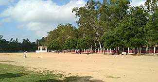
Ramna Maidan
Ramna Maidan, located in Arrah, Bhojpur District, Bihar, the one of the largest urban parks in Arrah, It is spread across 60 acres of land.
Arrah–Chhapra Bridge
Arrah–Chhapra Bridge is also called Veer Kunwar singh Setu which connects Arrah and Chhapra is the longest multi span extradosed bridge in the world with a length of 1920m.[20]
Maharaja College, Ara
The present Maharaja college premises is an important historical site.
Masarh
Masarh is a village 10 km from Arrah, the Lion capitals of Mauryan period have been found here. Masarh has been identified by Cunningham with Mo-ho-so-lo of the Chinese pilgrim Huen Tsang,
Arrah House
Arrah House is a small British building in the premises of Maharaja College.
Holy Saviour Church
Holy Saviour Church is a church in Arrah, Built by Britishers in 1911, When King of United Kingdom George V visited the city.
Education
Schools in Arrah are either government-run or private schools. Schools are affiliated by Central Board of Secondary Education and Bihar School Examination Board.
Veer Kunwar Singh University is located here. Harprasad Das Jain College, Maharaja Collage, Sahajanand Brahmarshi College, Jagjiwan College, Mahila College are some of the premier institutions for higher education.
The list of Colleges in Arrah are:
In 2018, Bihar government has opened Government Engineering Colleges in each district of Bihar under the Department of Science and Technology. Government Engineering College, Bhojpur runs in the campus of Bakhtiyarpur College of Engineering and its own campus will be completed by 2020.[21]
Sports
Cricket is the most popular sport, however other sports such as volleyball, basketball, and athletics are also played.
Veer Kunwar Singh Stadium is the stadium situated in the Ramna Maidan which hosts various cricket, football, and hockey tournaments. Other grounds in the town are Ramna Maidan, Maharaja college ground, Airport Ground, and Jain Collage Ground.
From 5–7 December 2019, East Zone Inter University Kabaddi championship took place in the premises of Maharaja College in which 47 universities of 12 different states participated.[22]
Notable people
- Acharya Shivpujan Sahay
- Amitava Kumar, journalist
- Babu Amar Singh, Freedom fighter
- Anjana Om Kashyap, Journalist
- Babu Jagjivan Ram, former deputy prime minister of India
- Ram Subhag Singh, Former Railway minister of India
- Bhuvaneshwar Prasad Sinha, 6th chief justice of India
- B. P. Singh, Judge of supreme court
- Dinesh Kumar Mani, scientist
- Veer Kunwar Singh, freedom fighter
- Hare Krishna Singh, fighter
- Ishwari Prasad Gupta, IAS
- Jagat Narain Lal
- Sachchidananda Sinha
- Meira Kumar (IFS), for Lok Sabha Speaker
- Vashishtha Narayan Singh, mathematician
- Mithileshwar
- Anil Sinha (IPS)
- Shashi Bhushan Sahai (IPS)
- S. H. Bihari, music director
- Muni Lall (IAS)
- Rohit Raj, Cricketer
- Amarendra Pratap Singh
- Brahmeshwar Singh
- Shivanand Tiwari
- Bindeshwari Dubey
- Anant Sharma
- Vinay Pathak, actor
- Pawan Singh, Singer , actor
- Neeraj Pandey
- Vishal Aditya Singh, actor
Popular references
Films and Songs
- Some shots of the feature film Gandhi were shot in Arrah near the Koilwar bridge.[23]
- Shots of the first Bhojpuri film Ganga Maiyya Tohe Piyari Chadhaibo were shot at Arrah railway station.
- The story of the Bollywood film Anaarkali of Aarah was based on a dancer of Arrah and her confrontation with the Vice chancellor of Bir Kuber University (originally Veer Kunwar Singh University).[24]
Books
- English book Two Months In Arrah, written in 1857, by a surgeon in British army named J.J. Halls, is an account of the Siege of Arrah.[25]
See also
- Arrah House
- Masarh lion
- Arrah–Chhapra Bridge
- Koilwar Bridge
References
- "Arrah City Population Census 2011–2019 | Bihar". www.census2011.co.in.
- "Bhojpur district full information". www.bihar.com.
- "Maps, Weather, and Airports for Ara, India". www.fallingrain.com.
- "Lion Motif in Mauryan Art: Indigenous or Foreign?" (PDF). heritageuniversityofkerala.com. Retrieved 11 April 2020.
- Singh, Rana (September 2019). "Masarh : A Great Archaeo-Historic Site of Bihar". J. P. University, Chapra. 63.
- Archaeological Survey of India: Reports 1862-1884, Volumes 3-23.
- "History | Welcome To Bhojpur District | India". Bhojpur.nic.in. 18 October 2019.
- Sinha, Nishi (1999). Tourism Perspective in Bihar. APH Publishing. p. 77. ISBN 9788170249757.
- Surendra Gopal (22 December 2017). Mapping Bihar: From Medieval to Modern Times. Taylor & Francis. pp. 289–295. ISBN 978-1-351-03416-6.
- Surinder Singh; I. D. Gaur (2008). Popular Literature and Pre-modern Societies in South Asia. Pearson Education India. p. 77. ISBN 978-81-317-1358-7.
- Chisholm, Hugh, ed. (1911). . Encyclopædia Britannica. 2 (11th ed.). Cambridge University Press. p. 642.
- Halls, John James (7 July 1860). Two months in Arrah in 1857 – via Internet Archive.
arrah.
- "About District | Welcome To Bhojpur District | India". Bhojpur.nic.in. 18 October 2019. Retrieved 28 October 2019.
- "Arrah, India Köppen Climate Classification (Weatherbase)". Weatherbase.
- "Weatherbase.com". Weatherbase. 2013. Retrieved on 31 July 2013.
- "Cities having population 1 lakh and above" (PDF). Provisional Population Totals, Census of India 2011. Retrieved 16 April 2012.
- "Tourism". Bhojpur.nic.in. 18 October 2019. Retrieved 3 March 2020.
- Tilak, Sudha G. Temple Tales: Secrets and Stories from India's Sacred Places. Hachette UK.
- Halls (1860). Two months in Arrah.
- "Arrah-Chhapra Bridge". Structurae. Retrieved 1 November 2019.
- "Official Website of Department of Science & Technology, Govt. Of Bihar :: Home Page".
- "Jagran Josh".
- "The ancient heritage behind our railway bridges". Rediff.
- Banerjee, Arnab (25 March 2017). "Anarkali of Arrah movie review: Bold, beautiful and endearing". Deccan Chronicle.
- Notes on Books: Being an Analysis of the Works Published During Each Quarter by Longmans, Green, and Company, Volume 2. Longmans, Green. 1865.
External links
| Authority control |
|
|---|