Darbhanga
Darbhanga is a Municipal Corporation in the Indian state of Bihar. It is the 6th largest city of Bihar, only after Patna, Gaya, Bhagalpur, Muzaffarpur, Bihar sharif. It is the headquarters of Darbhanga district and Darbhanga division and was the seat of the Raj Darbhanga and capital of the Mithila region.
Darbhanga | |
|---|---|
Metropolitan city | |
 | |
| Coordinates: 26.17°N 85.9°E | |
| Country | India |
| State | Bihar |
| Region | Mithila |
| District | Darbhanga |
| Government | |
| • Type | Municipal Corporation |
| • Body | Darbhanga Municipal Corporation |
| • Mayor | Baijanti Devi Khedia |
| • Deputy Mayor | Sri. Badruzzma Khan |
| • Municipal commissioner | Sri. Nagendra Kumar Singh, BAS[1] |
| • MP | Gopal Jee Thakur, BJP |
| • MLC | Dr. Dilip Kumar Choudhary & Dr. Madan Mohan Jha INC[2] Sunil Kumar Singh BJP |
| Elevation | 52 m (171 ft) |
| Population (2011) | |
| • Total | 267,348 |
| Languages | |
| • Official | Hindi |
| • Additional official | Urdu[3] |
| • Regional Languages | Maithili, English |
| Time zone | UTC+5:30 (IST) |
| PIN | 846003–846005[4] |
| Telephone code | 06272 |
| ISO 3166 code | IN-BR |
| Vehicle registration | BR-07 |
| Sex ratio | 910:1000 ♂/♀ |
| Lok Sabha constituency | Darbhanga |
| Vidhan Sabha constituency | Darbhanga, Darbhanga Rural, Bahadurpur, Keoti, Jale, Kusheshwar Asthan, Gaura Bauram, Benipur, Alinagar, Hayaghat |
| Website | darbhanga |


History
Darbhanga is made up of two words Dar and Banga which translates to door to Bengal.
Excavation at Balirajgarh revealed brick fortifications dating back to 2nd century BC.[5]
Demographics
The 2011 Census of India recorded Darbhanga as a municipal corporation with its population of 267,348 comprising 142,377 males and 124,971 females while the district as a whole has a population of 3 million.[6] It is the 6th largest city in Bihar in terms of urban population. Males constitute 52.6% of the population and females 47.4%. Darbhanga has an average literacy rate of 79.40%, while the male literacy rate is 85.08% with women at 73.08%.[7]
Climate
Darbhanga has a humid subtropical climate (Köppen climate classification Cwa).
| Climate data for Darbhanga | |||||||||||||
|---|---|---|---|---|---|---|---|---|---|---|---|---|---|
| Month | Jan | Feb | Mar | Apr | May | Jun | Jul | Aug | Sep | Oct | Nov | Dec | Year |
| Record high °C (°F) | 30.4 (86.7) |
33.9 (93.0) |
39.9 (103.8) |
42.0 (107.6) |
41.9 (107.4) |
43.4 (110.1) |
39.1 (102.4) |
38.4 (101.1) |
39.6 (103.3) |
39.2 (102.6) |
33.9 (93.0) |
29.9 (85.8) |
43.4 (110.1) |
| Average high °C (°F) | 22.1 (71.8) |
25.8 (78.4) |
31.0 (87.8) |
34.1 (93.4) |
35.0 (95.0) |
34.9 (94.8) |
32.5 (90.5) |
32.8 (91.0) |
32.5 (90.5) |
31.6 (88.9) |
28.0 (82.4) |
24.8 (76.6) |
30.68 (87.22) |
| Average low °C (°F) | 9.2 (48.6) |
11.0 (51.8) |
15.1 (59.2) |
19.1 (66.4) |
21.2 (70.2) |
22.9 (73.2) |
23.8 (74.8) |
24.2 (75.6) |
23.8 (74.8) |
21.2 (70.2) |
15.8 (60.4) |
10.6 (51.1) |
18.18 (64.72) |
| Record low °C (°F) | −0.2 (31.6) |
−0.2 (31.6) |
3.9 (39.0) |
9.2 (48.6) |
10.4 (50.7) |
15.9 (60.6) |
18.7 (65.7) |
19.4 (66.9) |
18.9 (66.0) |
12.7 (54.9) |
7.2 (45.0) |
2.4 (36.3) |
−0.2 (31.6) |
| Average precipitation mm (inches) | 13.0 (0.51) |
14.0 (0.55) |
9.0 (0.35) |
29.0 (1.14) |
76.0 (2.99) |
139.0 (5.47) |
353.0 (13.90) |
254.0 (10.00) |
193.0 (7.60) |
73.0 (2.87) |
6.0 (0.24) |
7.0 (0.28) |
1,166 (45.9) |
| Average rainy days | 1.6 | 1.7 | 1.6 | 2.6 | 4.6 | 7.6 | 16.4 | 12.2 | 10.5 | 3.4 | 0.5 | 1.0 | 63.7 |
| Average relative humidity (%) | 68 | 63 | 49 | 56 | 60 | 70 | 78 | 79 | 79 | 73 | 66 | 67 | 67 |
| Source: NOAA (1971–1990)[8] | |||||||||||||
Geography
Darbhanga is located in the northern part of Bihar.
Places adjacent to Darbhanga | ||||||||||
|---|---|---|---|---|---|---|---|---|---|---|
| ||||||||||
Transport
Railways
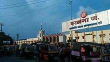
Darbhanga Junction lies on the East Central Railway. It is connected directly to all the major cities of India.
Of the beginning of railway in Darbhanga and its neighbouring areas, The Imperial Gazetteer of India noted:
The famine of 1874 gave a great impetus to the construction of railways, and the District is on the whole well off in the matter of communications. Its south-west corner is traversed for 29 miles by the main line of the Bengal and North-Western Railway, and also by 25 miles of the new chord-line from Hajipur to Bachwara, which runs parallel to the Ganges embankment from east to west. From Samastipur a line runs to Darbhanga town and there branches off in two directions, the first north-west to Sitamarhi through Kamtaul and Jogiara, and the other due east to Khanwa Ghat on the Kosi (Old streem) near Pratapganj. The total length of the line within the District is 146 miles. Most of the earthwork for a line from Sakri to Jaynagar on the Nepal frontier was completed as a relief work during the famine of 1897 ; and the line, which has now been opened, should tap a large grain supply from Nepal.[9]
Darbhanga Junction connects a large part of North Bihar and the Terai of Nepal with the rest of India as it serves as a major railhead. It is the main station of Darbhanga and the district of Madhubani.
Roadways

Darbhanga is connected to other parts of India by National Highway 27, National Highway 527B and Bihar State highways 50, 56, 88 and 75. Darbhanga is also connected to Madhubani and Sitamarhi.
The East-West Corridor expressway, which connects Porbandar in Gujarat to Silchar in Assam, passes through Darbhanga.
Public transport
For local transport, the commuters have the options of buses operated by BSRTC and auto-rickshaw. There is a bus stand and a new interstate bus stand is under construction. Bus services are available from Darbhanga to all the nearby major cities viz. Patna, Gaya, Kolkata, Purnia, Bhagalpur, Muzaffarpur, Ranchi, Jamshedpur.
Darbhanga Airport
Darbhanga Airport is a military air force base. The runway length is more than 9,000 feet.[10] It is being upgraded for commercial flights and scheduled flights to Mumbai, Bengaluru and New Delhi will be started by SpiceJet by April 2020 once terminal work is completed.[11]
Nearby Airports
Rajbiraj Airport is the second nearest operational airport roughly 121 km away. Shree Airlines operates daily flights between Rajbiraj and Kathmandu[12]. The nearest domestic airport to Darbhanga is Lok Nayak Jayaprakash Airport in Patna, approximately 139 kilometres (86 mi) away.
Media and communications
All India Radio has a 20 kW medium-wave radio station in Darbhanga which transmits various programmes of mass interest and covers a part of North Bihar as well as the Terai of Nepal.
Doordarshan has one DD National and one DD News LPT relay transmitters.
Education
Among the educational institutions are:
Medical colleges

- Darbhanga Medical College and Hospital
- Shyama Surgical Sansthan Hospital
- AIIMS, Darbhanga (Under Construction)
University
- IGNOU Regional Centre
- MANUU Regional Centre
- Lalit Narayan Mithila University
- Kameshwar Singh Darbhanga Sanskrit University
Engineering and technology colleges
- Women's Institute of Technology
- Darbhanga College of Engineering (JMIT)
Colleges
Schools
- Holy Cross School
- Jesus & Mary Academy
- Madonna English School
- Rose Public School
- D.A.V. Public School
- Darbhanga public school
- Public school darbhanga
Tourism
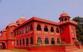
There are many tourist places in Darbhanga like Maharajadhiraja Lakshmishwar Singh Museum, Chandradhari Museum, Darbhanga Fort, Shyama Mai Temple, Anand Bag Palace, Nargona Palace
Notable people
- Kameshwar Singh Maharaja
- Lakshmeshwar Singh Maharaja
- Rameshwar Singh Maharaja
- Veena Devi, Indian politician, Member of 17th Lok Sabha
- Abdul Bari Siddiqui Current MLA from Alinagar Darbhanga
- Amarnath Gami Former MLA from Hayaghat Darbhanga
- Anirudha Sinha Former MP hails from Darbhanga
- Badri Narain Sinha IPS
- Bhawana Kanth First female Fighter pilot of India
- Binod Bihari Verma Writer
- Binodanand Jha Former MP from Darbhanga
- Dhanik Lal Mandal MP Hails from Darbhanga
- Gangesha Upadhyaya an Indian mathematician and philosopher from Darbhanga
- Gonu Jha Pratyutpannamati (ready-witted)
- Gopal Jee Thakur Former MLA and Present MP
- Gul Mohammad Khan A Bangladeshi musician hails From Darbhanga
- H. C. Verma Known as Concepts of Physics
- Hukmdev Narayan Yadav Former MP hails From Darbhanga
- Kirti Azad Former MP From Darbhanga and Former Indian cricketer
- Kaveri Jha Bollywood Actress
- Mohammad Ali Ashraf Fatmi Former MP
- M J Warsi An Indian linguist
- Nagarjun Poet, Writer, Essayist and Novelist hails from Darbhanga
- Narayan Das (politician)
- Nigamananda Saraswati A Hindu monk
- Prabhat Jha (politician)
- Parmanand Jha First Vice President of Nepal
- Ram Chatur Mallick An Indian classical musician
- Ram Gopal Bajaj Bollywood Director
- Ramnandan Mishra An Indian nationalist who fought for India's freedom from British rule
- Sanjay Paswan MP hails From Darbhanga
- Sanjay Saraogi MLA from Darbhanga vidhan sabha constituency
- Satya Narayan Sinha (Politician)
- Surendra Jha 'Suman' Poet, Freedom Fighter, Politician Essayist, Literary critic, journalist, publisher and Academician
- Sanjay Mishra (actor) Bollywood Actor
- Tariq-ur-Rehman An Indian Cricketer
- Tochi Raina An Indian singer, Composer and Philosopher
- Umadhar Singh (politician) hails from Darbhanga
- Yamuna Karjee An Indian independence activist.
See also
- Laheriasarai
- Darbhanga Planetarium

References
- https://nagarseva.bihar.gov.in/darbhanga/SectionInformation.html?ViewCommitee
- http://www.biharvidhanparishad.gov.in/MMembers1.htm
- https://web.archive.org/web/20170525141614/http://nclm.nic.in/shared/linkimages/NCLM52ndReport.pdf
- "STD & PIN Codes". Retrieved 23 January 2020.
- A., Ghosh (1965). Indian Archaeology:A Review. New Dehli: Archaeological Survey of India. pp. 3–5.
- https://www.census2011.co.in/census/city/164-darbhanga.html
- "Census of India: View Population Details". www.censusindia.gov.in. Government of India. 2001. Archived from the original on 27 April 2016. Retrieved 14 January 2016.
- "Zahedan Climate Normals 1971–1990". National Oceanic and Atmospheric Administration. Archived from the original on 23 December 2012. Retrieved 22 December 2012.
- "Archived copy". Archived from the original on 4 March 2016. Retrieved 14 January 2016.CS1 maint: archived copy as title (link)
- "Darbhanga Airport".
- "SpiceJet to operate flights from Darbhanga".
- Rajbiraj Airport to resume its flight services from May 8 as Shree Airline prepares for flight operation
External links
| Authority control |
|
|---|
| State symbols | |
|---|---|
| History |
|
| Administration |
|
| Overviews | |
| Divisions and districts | |
| Cities | |
| Municipal Corporation |
|
| Poltics | |
| Culture |
|