Muzaffarpur district
Muzaffarpur District is one of the thirty-eight districts of Bihar state, India. Muzaffarpur district is part of and also the headquarters of Tirhut Division[1] (Tirhut). Tirhut is the ancient name of all of northern Bihar.
Muzaffarpur district | |
|---|---|
District of Bihar | |
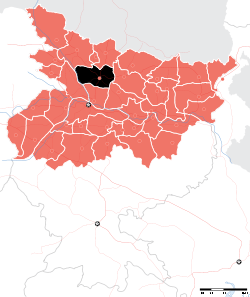 Location of Muzaffarpur district in Bihar | |
| Country | India |
| State | Bihar |
| Division | Tirhut |
| Headquarters | Muzaffarpur |
| Government | |
| • Lok Sabha constituencies | Muzaffarpur, Vaishali |
| • Vidhan Sabha constituencies | Gaighat, Aurai, Minapur, Bochahan, Sakra, Kurhani, Muzaffarpur, Kanti, Baruraj, Paroo, Sahebganj |
| Area | |
| • Total | 3,173 km2 (1,225 sq mi) |
| Population (2011) | |
| • Total | 4,801,062 |
| • Density | 1,500/km2 (3,900/sq mi) |
| Demographics | |
| • Literacy | |
| • Sex ratio | 900 |
| Time zone | UTC+05:30 (IST) |
| Major highways | NH 57, NH 28, NH 22, NH 102, NH 527C |
| Website | http://muzaffarpur.bih.nic.in/ |
History
Muzaffarpur is a part of Mithila Region of Ancient Vajji mahājanapada, one of the principal mahājanapadas of Ancient India.
Muzaffarpur fostered political leaders and statesmen alike among whom were Rajendra Prasad, George Fernandes, Janki Ballabh Shastri, a great Maithili writer Parmanandan Shashtri and Devesh Chandra Thakur. The language of the region is Bajjika (dialect language of Maithili) as per George Grierson. However, Maithili is also spoken in Muzaffarpur District.
In 1972 both Sitamarhi and Vaishali districts were split from Muzaffarpur.[2]
Geography
Muzaffarpur district is served by rivers Gandak, Budhi Gandak, Bagmati and Lakhandei. Many streams pass through the district. The area has been prone to floods. The district lies in the fertile region of Gangetic plain. Muzaffarpur district occupies an area of 3,175.9 square kilometres (1,226.2 sq mi),[3] comparatively equivalent to Canada's Mansel Island.[4]
Economy
GDP Per capita Income of Muzaffarpur is $2,507 and total GDP of District is $4.5 Billion as by 2019 Reports which is 4.7% of Bihar GDP.[5]
Lychee
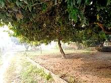
The litchi crop, which is available from May to June, is mainly cultivated in the districts of Muzaffarpur and surrounding districts, in an area of about 25,800 hectares producing about 300,000 tonnes every year. Lychee is exported to big cities like Bombay, Kolkata and to other countries. India's share in the world litchi market amounts to less than 1%. The names of the litchi produced in quality.[6]
Industry
It has many industries ranging from small to big. Prabhat Zarda Factory, Ganesh Foundries Limited, Bharat Wagon and Engineering, N.T.P.C., Kanti Thermal Power Station, Bihar Drugs & Organic Chemicals Ltd., Muzaffarpur – a unit of IDPL, units of Leather Development Corporation, Muzaffarpur Dairy, a unit of the Bihar State Dairy Corporation unit Bihar State Cooperative Milk Producers’ Federation Ltd., Muzaffarpur producing Sudha brand packaged milk are the major industries located in Muzaffarpur city and its periphery. The above industries have generated considerable employment and have also been helpful in establishing a number of small industries including a few cottage industries. The most important item that is manufactured in Muzaffarpur town is railway wagon. Muzaffarpur city is an important centre for the wholesale cloth trade. Agriculture-based industries such as sugar mills and Britannia Biscuits have newly been established in city.[7]
Demographics
According to the 2011 census Muzaffarpur district has a population of 4,801,062, roughly equal to the nation of Singapore[8] or the US state of Alabama.[9] This gives it a ranking of 24th th in India (out of a total of 640). The district has a population density of 1,514 inhabitants per square kilometre (3,920/sq mi). Its population growth rate over the decade 2001-2011 was 28.14%. Muzaffarpur has a sex ratio of 900 females for every 1000 males, and a literacy rate of 63.4%.
At the time of the 2011 Census of India, 90.93% of the population in the district spoke Hindi, 7.65% Urdu and 1.33% Maithili as their first language.[10]
| Historical population | ||
|---|---|---|
| Year | Pop. | ±% p.a. |
| 1901 | 1,078,094 | — |
| 1911 | 1,113,058 | +0.32% |
| 1921 | 1,077,631 | −0.32% |
| 1931 | 1,150,419 | +0.66% |
| 1941 | 1,269,186 | +0.99% |
| 1951 | 1,377,181 | +0.82% |
| 1961 | 1,598,346 | +1.50% |
| 1971 | 1,909,059 | +1.79% |
| 1981 | 2,357,388 | +2.13% |
| 1991 | 2,953,903 | +2.28% |
| 2001 | 3,746,714 | +2.41% |
| 2011 | 4,801,062 | +2.51% |
| source:[11] | ||
References
- http://tirhut-muzaffarpur.bih.nic.in/
- Law, Gwillim (25 September 2011). "Districts of India". Statoids. Retrieved 11 October 2011.
- "Muzaffarpur Geographical At a Glance". Retrieved 10 July 2015.
- "Island Directory Tables: Islands by Land Area". United Nations Environment Program. 18 February 1998. Retrieved 11 October 2011.
Mansel Island 3,180km2
- "District Development Report" (PDF).
- "7. LYCHEE PRODUCTION IN INDIA". Fao.org. 31 May 1992. Retrieved 2 August 2014.
- "Archived copy". Archived from the original on 28 August 2011. Retrieved 11 March 2012.CS1 maint: archived copy as title (link)
- US Directorate of Intelligence. "Country Comparison:Population". Retrieved 1 October 2011.
Singapore 4,740,737 July 2011 est.
- "2010 Resident Population Data". U. S. Census Bureau. Retrieved 30 September 2011.
Alabama 4,779,736
- "C-16 Population By Mother Tongue - Bihar". censusindia.gov.in. Retrieved 27 September 2019.
- Decadal Variation In Population Since 1901
| Wikimedia Commons has media related to Muzaffarpur district. |
External links
Places adjacent to Muzaffarpur district | ||||||||||
|---|---|---|---|---|---|---|---|---|---|---|
| ||||||||||
| State symbols | |
|---|---|
| History |
|
| Administration |
|
| Overviews | |
| Divisions and districts | |
| Cities | |
| Municipal Corporation |
|
| Poltics | |
| Culture |
|