Bihar Sharif
Bihar Sharif is the headquarters of Nalanda district and the fifth-largest sub-metropolitan area in the eastern Indian state of Bihar. Its name is a combination of two words: Bihar, derived from vihara (meaning Buddhist monastery), also the name of the state; and Sharif, referring to the resting place of the Sufi saint Makhdoom Sharfuddin Ahmed Yahya Maneri. The city is a hub of education and trade in southern Bihar, and the economy centers around agriculture supplemented by tourism, the education sector and household manufacturing. The ruins of the ancient Nalanda Mahavihara, a UNESCO World Heritage Site, are located near the city.
Bihar Sharif | |
|---|---|
Sub-Metropolitan | |
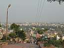
Tomb of Ibrahim Baya, The City Skyline, View of Hiranya Parbat from NH 20. | |
| Nickname(s): Odantapuri | |
 Bihar Sharif | |
| Coordinates: 25.197°N 85.518°E | |
| Country | India |
| State | Bihar |
| Division | Patna |
| District | Nalanda district |
| Named for | Study hub |
| Government | |
| • Type | Municipal Corporation |
| • Body | Bihar sharif Municipal Corporation |
| • District Magistrate | Yogendra Singh,[1] IAS |
| • Superintendent of Police, Nalanda | Nilesh Kumar,[1] IPS |
| • Municipal Commissioner | Sri Anshul Agrawal,[2] IAS |
| • Mayor | Veena Kumari[3] |
| Area | |
| • Sub-Metropolitan | 152.94 km2 (59.05 sq mi) |
| • Urban | 23.5 km2 (9.1 sq mi) |
| • Regional planning[4] | 78.53 km2 (30.32 sq mi) |
| Elevation | 55 m (180 ft) |
| Population (2016) | |
| • Sub-Metropolitan | 369,972 |
| • Rank | 5th in Bihar 153rd in India |
| • Density | 15,743/km2 (40,770/sq mi) |
| Language | |
| • Official | Hindi[5] |
| • Additional official | Urdu[5] |
| • Local | Magahi |
| Time zone | UTC+5:30 (IST) |
| PIN | 803101 803118 803216 803111 803113 |
| Telephone code | +916112 |
| ISO 3166 code | IN-BR |
| Vehicle registration | BR-21 |
| Loksabha Constituency | Nalanda (29) |
| Vidhan Sabha Constituency | Bihar Sharif (172) |
| Website | Bihar Sharif - Nalanda Bihar Sharif - Nagarseva |

Under the Pala Empire, Odantapuri, a major Buddhist monastic university was built at the site of Bihar Sharif. It eventually became the capital of Magadha, and then part of the Muslim Delhi Sultanate in the late 12th century, though local Rajputs soon re-established effective control. In the early 14th century, it was permanently captured by the Delhi Sultanate. Bihar Sharif was later ruled by other Muslim dynasties and then the British until Indian independence in 1947. The city has important Jain, Buddhist, Hindu and Muslim heritage and landmarks.
Bihar Sharif is one of the hundred Indian cities selected to gain funds under Prime Minister Narendra Modi's flagship Smart Cities Mission.[6] Bihar Sharif was selected in the preliminary list of 100 cities in July 2015 that were to compete for the Smart Cities project. As far as funding is concerned, the municipal corporation would continue to receive annual funding until the completion of the Smart Cities project, which was initially supposed to come to an end in the fiscal year 2019-20 but is now likely to be extended up to the fiscal year 2021–22.
History
Pre-Islamic period and Odantapuri University
The name Bihar is derived from vihar or vihara, meaning Buddhist monastery, a reference to the ancient Odantapuri University established near the city in the 7th century CE by Pala king Gopala I.[7][8] The settlement does, however, predate the Buddha. It became the capital of the Magadha kingdom from the rule of the Pala Empire. Odantapuri is considered to have been the second-oldest of India's Mahaviharas, and it was located at the foot of Bari Pahari (English: Big Hill). According to Tibetan records it housed about 12,000 students and was an important centre of Buddhist learning. Acharya Sri Ganga of Vikramashila was a student there. The monks of Odantapuri are credited with propagating Buddhism in Bhutan. The Big Hill or Badi Pahadi was known as Pashravati in those days.
Delhi Sultanate era
In 1193, during the time of Ikhtiyar ad-Din Muhammad bin Bakhtiyar Khilji's conquest of Bihar, he came to conquer eastern parts of India and destroyed Nalanda University. En route to Nalanda, he allegedly damaged the Buddhist monasteries of a place now called Bakhtiyarpur. He then came to Vihar, where he completely destroyed Odantapuri University, and the Buddhist viharas before leaving for Nalanda. A few years after Khilji's departure, local Bundela Rajputs regained control of the city from its Muslim rulers. Bundela Rajputs then ruled the area until the reign of Raja Biththal, remaining autonomous for all practical purposes despite nominal control from Delhi.
The district of Nalanda formed a part of territory under Muslim rulers of Bengal till 1320 AD when Ghiyasuddin Tughlaq separated Bihar from Bengal.
Delhi Sultan Muhammad bin Tughluq (r. 1324–1351 CE) then sent Syed Ibrahim Mallick with an army to conquer the Magadha region. After a fierce battle, the outnumbered Raja army was defeated and Raja Biththal was killed. The conquest of Bihar was a major achievement for Delhi, and on this occasion the Sultan conferred upon Syed Ibrahim Mallick the title of "Madarul Mulk", after which he was called "Mallick Baya". He was then appointed governor of Bihar by the Sultan, and he ruled over the region until his assassination in 1353 CE. Descendants of the Bundela Rajputs are now settled in Tungi village and Garhpar in Bihar Sharif.
Its control passed into the hands of the Sherqui Dynasty of Jaunpur from 1394 to 1486 CE. After that it was amalgamated with the Muslim kingdom of Gauda.
Later history
After the Delhi Sultanate, the first Sur emperor, Sher Shah Suri (r. 1540–1545 CE), moved the regional capital to Patliputra (modern-day Patna), and the whole Magadha region came to be called Bihar. Before that the residence of the Muslim governors of Bihar remained at Bihar Sharif until 1541 CE. Patna became a central place and Bihar Sharif lost its importance. However, Bihar Sharif continued to be enriched with buildings by the Muhammedans, and its sacred tombs have been visited by pilgrims for many centuries till modern day. The city still retains traces of its former importance and glory as a place of Muslim pilgrimage.
In 1867, the city was officially declared a municipality.[7]
Geography
Bihar Sharif is located 74 km (46 mi) from Patna, the capital of Bihar state (via NH 30 and 20). It is situated at the foot of Badi Pahari (a.k.a. Hiranya Parbat) and on the bank of the Panchanan River. The land around Bihar Sharif is very fertile, with alluvial soil deposited by several rivers. These local rivers include the Mahane, the Panchanan – which divides west of Pawapuri into the Goithwa, Soyaba and smaller rivers – the Zerain, and others. To the west is the Paimar River, a tributary of the Ganges.[7]
Economy
Agriculture is the main economic activity of Bihar Sharif, with crops including cauliflower, potato, mustard seed and other vegetables, which are sold to neighbouring states. The region is well known for extensive production of vegetables and there are research centres of vegetables located here.
- Indo-Israel centre for Excellence in Vegetables, Chandi[9]
- Potato Research Centre, Nalanda

Tourism to nearby sites like Nalanda, Rajgir and Pawapuri also boosts the city's economy considerably, as do footwear and garments manufactured by household industries.The locality of Sohsarai in the city hosts an extensive textile market, which is known as "Mini Surat".
As of 1981, the city had a major beedi cigarette industry which employed 15,000 people, mainly Muslims and some lower-caste Hindus.[10]
In recent years the city has changed from a trade-based economy to an education hub. Various schools and coaching centres are a new symbol of awareness about education among people in the surrounding rural areas.
Bihar Sharif is one of four cities selected in Bihar state among the 100 Indian cities to developed as smart cities under Prime Minister Narendra Modi's flagship Smart Cities Mission.[11] It was not included in the first twenty cities to receive funding.[12]
Demographics
As of the 2011 India census, Bihar Sharif had a population of 297,268,[13] up from 231,972 in 2001[14] and around 130,000 in 1981.[10] The sex ratio was 916 females per 1000 males, with a slightly higher ratio of 927 females per 1,000 males among children.[13] The overall literacy rate was 75.30%, with male literacy at 80.80% and female literacy at 69.28%.[13] Caste groups with significant populations include the Kurmi, Koyri, Yadav, and Baniyas. Most Muslims speak Urdu and belong to the Sunni Hanafi denomination. The Koyri and Baniya are old settlers while others have moved from villages around the city.
Religion
According to the 2011 census, 65.86% of the city's population identifies as Hindu, 33.59% identifies as Muslim, 0.34% did not answer the census question, 0.17% identifies as Christian, and fewer than fifty identified with each of the other religious groups on the survey.[13] A 1981 report lists a 48% proportion of Muslims and notes this as unusual for the area.[10]
In 2012, plans were announced for the construction of a local Bahá'í House of Worship in Bihar Sharif.[16] This would be only the second House of Worship for India's nearly two million Bahá'ís[17] (the first being the well-known Lotus Temple in Delhi),[18] and one of the first two local Bahá'í Houses of Worship in Asia (the other being in Battambang, Cambodia).[16]
Administration
- The Town Police Station (Bihar Thana) is the first child-friendly police station of the state of Bihar.
Transport
Roadways
The city is connected by road to major cities like Patna, Rajgir, Nalanda, Nawada, Harnaut, Jamshedpur, Ranchi, Dhanbad, Bokaro, Koderma, Kolkata, Gaya, Hazaribag, Barhi, Jehanabad, Bakhtiyarpur, Barh, Mokama and Ramgarh. Being the district headquarters, it has a major transport hub and has regular bus service to all other major destinations in the region.
NH 33 and NH 20, a part of Asian Highway Network and AH42 passes through the city. NH 33 and NH 20 intersects each other in the city. NH 20 connects to Patna via Bakhtiyarpur and to Nawada, Barhi, Koderma, Hazaribagh and Ranchi. NH 33 connects the city to Mokama, Barbigha, Asthawan, Jahanabad and Arwal.
NH 120 starts here and runs to Dumraon via Nalanda, Rajgir and Gaya.
SH 78 connects it with Chandi, Daniyawan and Hilsa.
Public Transport
The city is also served by Public City Bus Service. Bihar Sharif became third city in Bihar to have this service after Patna and Gaya. Started in December 2018, it serves the city on the Rajgir More (Kargil Chowk)-Sohsarai route.
Railways
Bihar Sharif Junction is on the Bakhtiyarpur-Tilaiya line, part of the national broad gauge network. The city is served by the Shramjeevi Express, a direct daily superfast train to New Delhi. There are also numerous passenger and express connections to the state capital, Patna, and to the hub at Rajgir which connects to many destinations in the country. Recently, the Fatuha–Islampur branch line has been connected to this route by linking Daniyawan to Bihar Sharif. The extension of passenger services to link Bihar Sharif with Hilsa, Sheikhpura and Gaya began in 2013. Pawapuri Road is another important railway station located in the southern outskirts of the city.
Airways
- The nearest airport is Patna Airport, about 86 km away, with carriers operating flights to major Indian cities.
- Gaya International Airport is about 95 km away.
Education
A number of colleges, schools and educational institutions are located in the city. Notable institutions include:
- Nalanda University (also known as Nalanda International University) is an international and research-intensive class located in the nearby historical city of Rajgir.[19]
- Nava Nalanda Mahavihara,a deemed to be university located in Nalanda, about 10–11 km away.[20]
- Vardhman Institute of Medical Sciences, popularly known as VIMS Pawapuri, is located about 14 km away in Pawapuri.[21]
- Nalanda College of Engineering,Chandi[22]
- Nalanda College, opened in 1870, is one of oldest colleges in Bihar.[23]
- K. K. University was opened in Bihar Sharif in 2017.[24]
- Magadh Homoeopathic Medical College, founded in 1969 is one of the reputed Private Homoeopathic Colleges in Bihar, affiliated to B.R.Ambedkar Bihar University, Muzaffarpur and is approved by Central Council of Indian Medicines.
- Sainik School, Nalanda is located about 14 km away at Nanand, Nalanda.[25]
- Jawahar Navodaya Vidyalaya, Nalanda is located about 22 km away at Rajgir, Nalanda.[26]
Media and Entertainment
Print media such as Dainik Jagran, Hindustan, Dainik Bhaskar, Prabhat Khabar, Aj and I-Next are available as well as English-language newspapers including Times of India, The Hindu along with various types of magazines.
Keshav Ram Bhatta, a Maharashtrian Brahman that settled in Bihar Sharif published "Bihar Bandhu"- the first Hindi newspaper from Bihar in 1872.[27]
Heritage and important sites
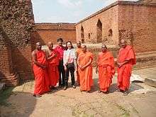
The city has many artefacts and relics of Buddhist and Jain heritage. (Mahavira, often regarded as the founder of Jainism, is said to have attained Nirvana at the nearby town of Pawapuri, where the famous Jal Mandir is situated.) Broken idols of Buddha and Mahavira can be found in the Nalanda Museum and in many temples. Nalanda College in Bihar Sharif and the locality of Garhpar have Buddhist monasteries. The ruins at Nalanda are 13 km (8.1 mi) from Bihar Sharif.[28]
There is also a notable pillar in Bihar Sharif dating to the 5th century at the time of the Gupta empire and contains two inscriptions of Gupta rulers, Kumaragupta and Skandagupta.[7]
Another notable site in the city is the Langot Fair at Baba Maniram Akhara; the Akhara of Sant Maniram was founded by Raja Biththal to train youth in fighting.
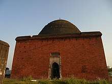
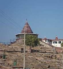
The mausoleum of Syed Ibrahim Mallick Baya is presently located on the top of the hill known as Hiranya Parvata.[7]
Badi Dargah, the shrine of the Sufi Saint Sheikh Makhdoom Sharfuddin Ahmed Yahya Maneri, is located near the ruins of Odantapuri. He is credited with converting many Hindus in the districts of Patna, Bihar Sharif, Gaya, Jehanabad, Arwal, Nawada, Jamui and Sheikhpura, and many Muslims celebrate Urs at the shrine each year in the month of Shawwal on the Hijri calendar.
Notable places
- Badi Dargah
The resting place of Sufi saint Sheikh Makhdoom Sharfuddin Ahmed Yahya Maneri. The annual festival of Urs is organised here. The inscription over its entrance mentions that the tomb was completed in 1569.


- Akhara of Baba Maniram
The site of the annual Langot Fair. A large temple complex and tank is also located here.
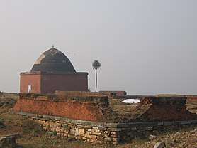
- Tomb of Syed Ibrahim Mallick Baya
The tomb of Syed Ibrahim Mallick Baya is located at the top of Hiranya Parvat. Constructed in 14th century, it is notable for its architecture and for the natural environment of its surroundings.
- Badi Pahari
Badi Pahadi also known as Hiranya Parvat has a rich history. It is said that Buddha spent his last monsoon in the vicinity of this hill. After his death, a monastery called the "Kapotica" or Pigeon Monastery was built thereon. Xuan Zang visited the monastery and mentioned it.
Most tourists visiting Biharsharif are domestic - from other places in Bihar and adjoining states. A large park, a temple and a mausoleum is located on Bari Pahari (Hiranya Parvat).
- Gupta Pillar
This is an ancient sandstone pillar situated in the compound of the Magistrate's court in Garhpar area of the city. It is 14 ft tall and has two inscription inscribed upon it of two Gupta Dynasty rulers, first of Kumaragupta (413-455 CE) and second of Skandagupta (456-480 CE).
- Bihar Sharif Museum
Housed in the building known as "Virasat Bihar", this museum opened in 1979 and housing relics and sculptures unearthed from the city and nearby areas as the area is very rich in archaeological remains. The stone sculptures housed here mostly belong to the Pala Empire period. There are medieval period sculptures, ancient pillars, Islamic inscriptions and Mughal coins.
- Vajra Vidya Phulahari Thrangu Monastery
A Buddhist monastery located on NH 20 near Hiranya Parvat.
- Mora Talab
A large tank said to be constructed by Queen Moora Devi, mother of the Mauryan Emperor Chandragupta Maurya. A Sun Temple is located here. This place is located by the NH 20 on the northern side of city.
- Nagar Nigam Park
Nagar Nigam Park is a park developed by the Municipal Corporation of Bihar Sharif on Badi Pahadi. The park features several fountains and cascades along with a children's park.
- Kundalpur(Nalanda)
Shri Kundalpur Digambar Jain Teertha Kshetra is located at a distance of 15 km near the ancient Sun-temple fame village of Bargaon in Nalanda. This is revered as the birthplace of Mahavira with Jain marbles temples.
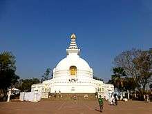
- Sariputta Stupa, Giriyak
The ancient stupa of Sariputta is located on Giriyak hills, around 21 km from the city. The stupa near the Ghora Katora lake of Rajgir rises to a height of 30 ft and is cylindrical in shape. It probably dates to Gupta period or even earlier.
- Nalanda
The ruins of Nalanda Mahavihara or simply called as Nalanda, a UNESCO World Heritage Site, are located near the city. Known as Oxford of ancient times, Nalanda is considered the first residential university of the world and a premier institute of learning in ancient India.
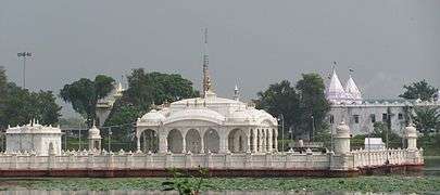
- Pawapuri
Pawapuri, a town located about 14 km away from the city is one of the holiest places of Jainism. The famous Jal Mandir is located here along with many other Jain temples.
- Rajgir
The city of Rajgir, one of the most visited places in Bihar, is about 25 km from Bihar Sharif.
Events
- Urs or Annual "Chiraga" Fair
- Annual Langot Fair held at Manibaba Akhara
Notable Persons
- Malik Ibrahim Bayu
- Makhdoom Sharfuddin Ahmed Yahya Maneri, A sufi mystic
- Vikas Kumar, Actor[29]
- L. S. N. Prasad, Founding Father of Indian Academy of Pediatrics and a Padma Shri recipient
- Aditya Kumar, Actor[30]
- Saba Karim, Former Cricketer
- Maulana Ali Hussain "Aasim Bihari", A freedom fighter and Father of the First Pasmanda Movement in India [31]
See also
- Nalanda
- List of cities in Bihar
References
| Wikimedia Commons has media related to Bihar Sharif. |
- "Nalanda District Officials Details | District Nalanda, Government of Bihar | India".
- "Urban Development and Housing Department,Govt of Bihar" (PDF).
- "E-Municipality Bihar".
- https://timesofindia.indiatimes.com/city/patna/37-villages-to-be-part-of-biharsharif-smart-city-project/articleshow/66799264.cms
- "52nd REPORT OF THE COMMISSIONER FOR LINGUISTIC MINORITIES IN INDIA" (PDF). nclm.nic.in. Ministry of Minority Affairs. Archived from the original (PDF) on 25 May 2017. Retrieved 7 December 2018.
- "Buoyed by smart city mission tag, Patna, Muzaffarpur gear up for makeover". hindustantimes.com/. 26 June 2017. Retrieved 30 June 2017.
- "Bihar Sharif". Encyclopædia Britannica. Retrieved 19 March 2016.
- "Odantapuri". Encyclopædia Britannica. Retrieved 19 March 2016.
- https://embassies.gov.il/delhi/Relations/Indo-Israel-AP/Pages/Locations.aspx
- Engineer, Ashgar Ali (16 May 1981). "Biharsharif Carnage: A Field Report". Economic and Political Weekly. 16 (20): 887–889. JSTOR 4369828.
- Jeelani, Mehboob (28 August 2015). "Centre unveils list of 98 smart cities; UP, TN strike it rich". The Hindu.
- "First 20 smart cities: From Jaipur to Kochi, here's the full list". 28 January 2016.
- "Biharsharif City Census 2011 data". 2011 Indian Census. Retrieved 27 March 2016.
- "Census of India 2001: Data from the 2001 Census, including cities, villages and towns (Provisional)". Census Commission of India. Archived from the original on 16 June 2004. Retrieved 1 November 2008.
- "Census 2011 Bihar Sharif". Census 2011. Retrieved 8 July 2017.
- "Plans to build new Houses of Worship announced". Baha'i World News Service. 22 April 2012. Retrieved 25 March 2016.
- "Most Baha'i Nations (2005)". The Association for Religion Data Archives. Archived from the original on 14 April 2010. Retrieved 23 June 2016.
- "Iconic "Lotus Temple" focus of worldwide campaign". Bahá'í World News Service. 6 October 2011. Retrieved 25 March 2016.
- "Home".
- "Nava Nalanda Mahavihara".
- "Vardhman Institute of Medical Sciences, Pawapuri, Nalanda Bihar". Retrieved 5 February 2020.
- "Home | Nalanda College".
- "nalandacollegebiharsharif.com". nalandacollegebiharsharif.com. Retrieved 5 February 2020.
- "K.K. University || Biharsharif".
- "HOME".
- https://www.navodaya.gov.in/nvs/nvs-school/NALANDA/en/home/
- Ahmad Qeyamuddin, Patna Through the ages: Glimpses of History, Society and Economy, Commonwealth Publishers, New Delhi, 1988
- http://www.britannica.com/nalanda
- https://m.timesofindia.com/city/patna/Bihar-youth-coaches-Bollywood-actors-in-diction/articleshow/29919910.cms
- https://m.timesofindia.com/city/patna/budding-actors-recount-journey-from-bihar-to-bollywood/amp_articleshow/76393023.cms
- https://roundtableindia.co.in/index.php?option=com_content&view=article&id=9145:the-first-pasamanda-movement-s-creator-and-freedom-fighter-maulana-ali-hussain-aasim-bihari&catid=115:dalitbahujan-renaissance&Itemid=127