East Champaran district
East Champaran is an administrative district in the state of Bihar in India. The district headquarters are located at Motihari.
East Champaran district | |
|---|---|
District of Bihar | |
 | |
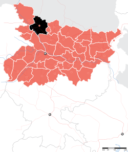 Location of East Champaran district in Bihar | |
| Country | India |
| State | Bihar |
| Division | Tirhut |
| Headquarters | Motihari |
| Government | |
| • Lok Sabha constituencies | Purvi Champaran, Paschim Champaran, Sheohar |
| • Vidhan Sabha constituencies | Raxaul, Sugauli, Narkatiya, Harsidhi, Govindganj, Kesaria, Kalyanpur, Pipra, Madhuban, Motihari, Chiraia, Dhaka |
| Area | |
| • Total | 3,968 km2 (1,532 sq mi) |
| Population (2011) | |
| • Total | 5,099,371 |
| • Density | 1,300/km2 (3,300/sq mi) |
| Demographics | |
| • Literacy | 55.79 per cent |
| • Sex ratio | 901 |
| Time zone | UTC+05:30 (IST) |
| Major highways | NH 28A, NH 104 |
| Average annual precipitation | 1241 mm |
| Website | http://eastchamparan.bih.nic.in/ |
About District
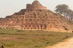
East Champaran District is functioning from 2 November 1972. The headquarter of district is at Motihari. It is situated at 26o 16' to 27o 1' North latitude and 84o 30' to 85o 16' East longitudes. Nepal makes its northern boundary, Sitamadhi and Sheohar eastern while Muzaffarpur South and with part of Gopalganj bounds it in western side. The name Champaran owes its origin to Champa-aranya or Champkatanys. Champa or Champaka means Magnolia and aranya means forest. Hence, Champaranya means Forest of Magnolia (CHAMPA) trees. The District comprises an area of 3968.0 km2 with 1344 villages having population of 50,82,868 as per 2011 census. The Administrative set up of the District is decentralized into 6 sub-division, 27 blocks, 27 Circles, 3 Nagar Parishads (Motihari, Raxaul and Dhaka), 6 Nagar Panchayats and 405 Panchayats. The Buddhist Stupta, Kesaria, Ashokan Pillar, Lauriya, Areraj, Gandhi Memorial, Someshwar Shiv Mandir, Areraj, Orwell's birthplace, Raxaul-Gate way to Nepal.
The district occupies an area of 3969 km2 and has a population of 3,933,636 (as of 2001). East Champaran is a part of Tirhut Division[1] (Tirhut). It is currently a part of the Red Corridor. During COVID-19 it's have 5 case . 3 of banjariya block and 1-1 of Areraj block and fenhara block
As of 2011, it is the second most populous district of Bihar (out of 39), after Patna.[2]
Geography
East Champaran district occupies an area of 3,968 square kilometres (1,532 sq mi),[3] comparatively equivalent to Vanuatu's Espiritu Santo.[4] Gandak, Burhi Gandak and Baghmati are important rivers flowing through this region.
Demographics
| Historical population | ||
|---|---|---|
| Year | Pop. | ±% p.a. |
| 1901 | 1,027,835 | — |
| 1911 | 1,095,530 | +0.64% |
| 1921 | 1,114,162 | +0.17% |
| 1931 | 1,231,756 | +1.01% |
| 1941 | 1,376,352 | +1.12% |
| 1951 | 1,443,961 | +0.48% |
| 1961 | 1,681,089 | +1.53% |
| 1971 | 1,956,084 | +1.53% |
| 1981 | 2,425,501 | +2.17% |
| 1991 | 3,043,061 | +2.29% |
| 2001 | 3,939,773 | +2.62% |
| 2011 | 5,099,371 | +2.61% |
| source:[5] | ||
According to the 2011 census East Champaran district has a population of 5,099,371,[2] roughly equal to the United Arab Emirates[6] or the US state of Colorado.[7] This gives it a ranking of 21st in India (out of a total of 640).[2] The district has a population density of 1,281 inhabitants per square kilometre (3,320/sq mi).[2] Its population growth rate over the decade 2001–2011 was 29.01%.[2] Purbi Champaran has a sex ratio of 901 females for every 1000 males,[2] and a literacy rate of 55.79%.[2]
Sub-divisions
- Motihari Sadar
- Areraj
- Raxual
- Shikarahna (Dhaka)
- Pakridayal
- Chakia
Some Villages:- Dhekahan, Baradih Bairiya, kundwa, Rampur, Karhan, kushhar, Sihorwa, Ranigunj, Chakia, Paharpur, Pipra kothi, Ujjain Lohiyar, Gayghat, Yadavpur etc. There are three Nagar Paris had towns in E. Champaran: Motihari, Raxaul, Dhaka and Ghorasahan. Dhaka and Ghorasahan has emerged as a new town with Dhaka is a second highest costly land after Raxaul.
Languages
At the time of the 2011 Census of India, 92.33% of the population in the district spoke Hindi and 7.33% Urdu as their first language.[8]
Languages include Bhojpuri, a tongue in the Bihari language group with almost 40 000 000 speakers, written in both the Devanagari and Kaithi scripts as well as Urdu language also Urdu.[9]
Non Governmental organization
See also
- Chakia
- Raxaul
- Dhaka, Bangladesh
- Motihari
- George Orwell
- Ramesh Chandra Jha
- Districts of Bihar
References
- "Tirhut Division". tirhut-muzaffarpur.bih.nic.in. Retrieved 11 April 2018.
- "District Census 2011". Census2011.co.in. 2011. Retrieved 30 September 2011.
- Srivastava, Dayawanti et al. (ed.) (2010). "States and Union Territories: Bihar: Government". India 2010: A Reference Annual (54th ed.). New Delhi, India: Additional Director General, Publications Division, Ministry of Information and Broadcasting (India), Government of India. pp. 1118–1119. ISBN 978-81-230-1617-7.CS1 maint: extra text: authors list (link)
- "Island Directory Tables: Islands by Land Area". United Nations Environment Program. 18 February 1998. Retrieved 11 October 2011.
Espiritu Santo 3,956km2
- Decadal Variation In Population Since 1901
- US Directorate of Intelligence. "Country Comparison:Population". Retrieved 1 October 2011.
United Arab Emirates 5,148,664
- "2010 Resident Population Data". U. S. Census Bureau. Archived from the original on 19 October 2013. Retrieved 30 September 2011.
Colorado 5,029,196
- 2011 Census of India, Population By Mother Tongue
- M. Paul Lewis, ed. (2009). "Bhojpuri: A language of India". Ethnologue: Languages of the World (16th ed.). Dallas, Texas: SIL International. Retrieved 30 September 2011.
- "Sanmat". www.ssnmtrust.org. Retrieved 7 January 2020.
- "Amit Choubey, social entrepreneur and Founder of SANMAT works hard to bring good change in the lives of marginalized sections of our society". www.entrepreneurshipindia.co.in. 30 August 2017. Retrieved 7 January 2020.
External links
Places adjacent to East Champaran district | ||||||||||
|---|---|---|---|---|---|---|---|---|---|---|
| ||||||||||
| State symbols | |
|---|---|
| History |
|
| Administration |
|
| Overviews | |
| Divisions and districts | |
| Cities | |
| Municipal Corporation |
|
| Poltics | |
| Culture |
|