Xammes
| Xammes | |
|---|---|
| Commune | |
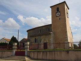 Église Saint-Clément | |
 Xammes Location within Grand Est region  Xammes | |
| Coordinates: 48°58′32″N 5°51′19″E / 48.9756°N 5.8553°ECoordinates: 48°58′32″N 5°51′19″E / 48.9756°N 5.8553°E | |
| Country | France |
| Region | Grand Est |
| Department | Meurthe-et-Moselle |
| Arrondissement | Toul |
| Canton | Le Nord-Toulois |
| Intercommunality | Communauté de communes Mad et Moselle |
| Government | |
| • Mayor (2014-2020) | Dominique Leroy |
| Area1 | 8.16 km2 (3.15 sq mi) |
| Population (2014)2 | 142 |
| • Density | 17/km2 (45/sq mi) |
| Time zone | UTC+1 (CET) |
| • Summer (DST) | UTC+2 (CEST) |
| INSEE/Postal code | 54594 /54470 |
| Elevation |
208–280 m (682–919 ft) (avg. 250 m or 820 ft) |
|
1 French Land Register data, which excludes lakes, ponds, glaciers > 1 km2 (0.386 sq mi or 247 acres) and river estuaries. 2 Population without double counting: residents of multiple communes (e.g., students and military personnel) only counted once. | |
Xammes is a commune in the Meurthe-et-Moselle department in north-eastern France.
History
It may have been the village Scannis mentioned in charters since 776. The church of Saint-Clément dates back to the 12th century.[1]
See also
References
- ↑ Mémoires de la Société d'archéologie lorraine (in French). 1871. p. 360.
| Wikimedia Commons has media related to Xammes. |
This article is issued from
Wikipedia.
The text is licensed under Creative Commons - Attribution - Sharealike.
Additional terms may apply for the media files.