Andilly, Meurthe-et-Moselle
| Andilly | ||
|---|---|---|
| Commune | ||
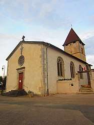 The church in Andilly | ||
| ||
 Andilly Location within Grand Est region  Andilly | ||
| Coordinates: 48°45′59″N 5°52′53″E / 48.7664°N 5.8814°ECoordinates: 48°45′59″N 5°52′53″E / 48.7664°N 5.8814°E | ||
| Country | France | |
| Region | Grand Est | |
| Department | Meurthe-et-Moselle | |
| Arrondissement | Toul | |
| Canton | Nord-Toulois | |
| Intercommunality | Toulois | |
| Government | ||
| • Mayor (2014-2020) | Joël Warchol | |
| Area1 | 7.12 km2 (2.75 sq mi) | |
| Population (2014)2 | 283 | |
| • Density | 40/km2 (100/sq mi) | |
| Time zone | UTC+1 (CET) | |
| • Summer (DST) | UTC+2 (CEST) | |
| INSEE/Postal code | 54016 /54200 | |
| Elevation |
213–254 m (699–833 ft) (avg. 220 m or 720 ft) | |
|
1 French Land Register data, which excludes lakes, ponds, glaciers > 1 km2 (0.386 sq mi or 247 acres) and river estuaries. 2 Population without double counting: residents of multiple communes (e.g., students and military personnel) only counted once. | ||

Andilly is a commune in the Meurthe-et-Moselle department in northeastern France.
Population
| Historical population | ||
|---|---|---|
| Year | Pop. | ±% |
| 1962 | 205 | — |
| 1968 | 202 | −1.5% |
| 1975 | 155 | −23.3% |
| 1982 | 190 | +22.6% |
| 1990 | 205 | +7.9% |
| 1999 | 218 | +6.3% |
| 2009 | 286 | +31.2% |
See also
References
| Wikimedia Commons has media related to Andilly (Meurthe-et-Moselle). |
This article is issued from
Wikipedia.
The text is licensed under Creative Commons - Attribution - Sharealike.
Additional terms may apply for the media files.