Art-sur-Meurthe
| Art-sur-Meurthe | ||
|---|---|---|
| Commune | ||
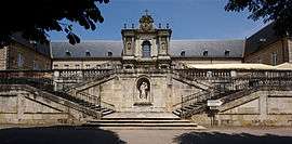 The charterhouse of Bosserville | ||
| ||
 Art-sur-Meurthe Location within Grand Est region  Art-sur-Meurthe | ||
| Coordinates: 48°39′24″N 6°15′58″E / 48.6567°N 6.2661°ECoordinates: 48°39′24″N 6°15′58″E / 48.6567°N 6.2661°E | ||
| Country | France | |
| Region | Grand Est | |
| Department | Meurthe-et-Moselle | |
| Arrondissement | Nancy | |
| Canton | Grand Couronné | |
| Intercommunality | Métropole Grand Nancy | |
| Government | ||
| • Mayor (2014-2020) | Jean-Pierre Dessein | |
| Area1 | 11.47 km2 (4.43 sq mi) | |
| Population (2015)2 | 1,303 | |
| • Density | 110/km2 (290/sq mi) | |
| Time zone | UTC+1 (CET) | |
| • Summer (DST) | UTC+2 (CEST) | |
| INSEE/Postal code | 54025 /54510 | |
| Elevation |
195–268 m (640–879 ft) (avg. 225 m or 738 ft) | |
|
1 French Land Register data, which excludes lakes, ponds, glaciers > 1 km2 (0.386 sq mi or 247 acres) and river estuaries. 2 Population without double counting: residents of multiple communes (e.g., students and military personnel) only counted once. | ||

Art-sur-Meurthe is a commune in the Meurthe-et-Moselle department in northeastern France.
Population
| Historical population | ||
|---|---|---|
| Year | Pop. | ±% |
| 1962 | 807 | — |
| 1968 | 849 | +5.2% |
| 1975 | 799 | −5.9% |
| 1982 | 814 | +1.9% |
| 1990 | 994 | +22.1% |
| 1999 | 1,109 | +11.6% |
| 2006 | 1,285 | +15.9% |
| 2009 | 1,294 | +0.7% |
| 2015 | 1,303 | +0.7% |
In the past, inhabitants of Art-sur-Meurthe were known by their neighbours as haut-la-queue ("hoity-toitys").[1]
See also
References
- ↑ Graham Robb, The Discovery of France, p36, Picador (2007), ISBN 978-0-330-42761-6, citing Vital Collet "Sobriquets caractérisant les habitants de villages lorrains" in Le Pays lorrain, Nancy (1908), pp442-449 and Henri-Adolphe Labourasse, "Anciens us, coutumes, légendes, supersititions, préjugés, etc. du département de la Meuse" in Mémoires de la Société des lettres, sciences et art de Bar-le-Duc, 1902, pp3-225
| Wikimedia Commons has media related to Art-sur-Meurthe. |
This article is issued from
Wikipedia.
The text is licensed under Creative Commons - Attribution - Sharealike.
Additional terms may apply for the media files.