Haroué
| Haroué | |
|---|---|
| Commune | |
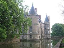 Château de Haroué | |
 Haroué Location within Grand Est region  Haroué | |
| Coordinates: 48°28′10″N 6°10′43″E / 48.4694°N 6.1786°ECoordinates: 48°28′10″N 6°10′43″E / 48.4694°N 6.1786°E | |
| Country | France |
| Region | Grand Est |
| Department | Meurthe-et-Moselle |
| Arrondissement | Nancy |
| Canton | Meine au Saintois |
| Intercommunality | Saintois |
| Government | |
| • Mayor (2001–2008) | Guy Bouvier |
| Area1 | 4.14 km2 (1.60 sq mi) |
| Population (2012)2 | 437 |
| • Density | 110/km2 (270/sq mi) |
| Time zone | UTC+1 (CET) |
| • Summer (DST) | UTC+2 (CEST) |
| INSEE/Postal code | 54252 /54740 |
| Elevation |
239–314 m (784–1,030 ft) (avg. 245 m or 804 ft) |
|
1 French Land Register data, which excludes lakes, ponds, glaciers > 1 km2 (0.386 sq mi or 247 acres) and river estuaries. 2 Population without double counting: residents of multiple communes (e.g., students and military personnel) only counted once. | |
Haroué is a commune in the Meurthe-et-Moselle department in north-eastern France.
Geography
The river Madon flows through the commune.
Historical Features
The Château d'Haroué was constructed between 1720 and 1732 by Germain Boffrand for Prince Marc de Beauvau, Viceroy of Tuscany. The architect had to integrate into his plans the four towers and the moat of the predating medieval castle of François de Bassompierre. The decoration of the castle was entrusted to artists from the Lorraine region: Jean Lamour (1698-1771) for the gates, the balcony, and the banister, Pillement (1698-1771) for the interior painting of one of the towers, and Barthélemy Guibal (1699-1757), the sculptor of the fountains of Place Stanislas in Nancy, for the statuary. The French park was designed by Emilio Terry.
See also
| Wikimedia Commons has media related to Haroué. |