Éply
| Eply | ||
|---|---|---|
| Commune | ||
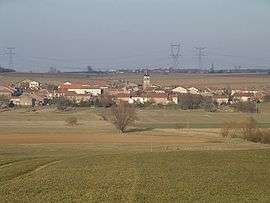 Eply seen from the road to Morville | ||
| ||
 Eply Location within Grand Est region  Eply | ||
| Coordinates: 48°55′14″N 6°10′52″E / 48.9206°N 6.1811°ECoordinates: 48°55′14″N 6°10′52″E / 48.9206°N 6.1811°E | ||
| Country | France | |
| Region | Grand Est | |
| Department | Meurthe-et-Moselle | |
| Arrondissement | Nancy | |
| Canton | Entre Seille et Meurthe | |
| Intercommunality | Communauté de communes de Seille et Mauchère | |
| Government | ||
| • Mayor (2008–2014) | Gérard Gay | |
| Area1 | 11.17 km2 (4.31 sq mi) | |
| Population (1999)2 | 247 | |
| • Density | 22/km2 (57/sq mi) | |
| Time zone | UTC+1 (CET) | |
| • Summer (DST) | UTC+2 (CEST) | |
| INSEE/Postal code | 54179 /54610 | |
| Elevation |
177–238 m (581–781 ft) (avg. 192 m or 630 ft) | |
|
1 French Land Register data, which excludes lakes, ponds, glaciers > 1 km2 (0.386 sq mi or 247 acres) and river estuaries. 2 Population without double counting: residents of multiple communes (e.g., students and military personnel) only counted once. | ||

Éply is a commune in the Meurthe-et-Moselle department in north-eastern France.
See also
| Wikimedia Commons has media related to Éply. |
This article is issued from
Wikipedia.
The text is licensed under Creative Commons - Attribution - Sharealike.
Additional terms may apply for the media files.