Allain, Meurthe-et-Moselle
| Allain | ||
|---|---|---|
| Commune | ||
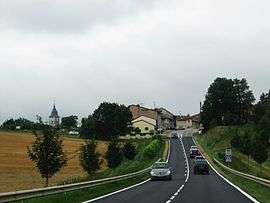 A general view of Allain | ||
| ||
 Allain Location within Grand Est region  Allain | ||
| Coordinates: 48°33′02″N 5°54′41″E / 48.5506°N 5.9114°ECoordinates: 48°33′02″N 5°54′41″E / 48.5506°N 5.9114°E | ||
| Country | France | |
| Region | Grand Est | |
| Department | Meurthe-et-Moselle | |
| Arrondissement | Toul | |
| Canton | Meine au Saintois | |
| Intercommunality | CC Pays de Colombey et Sud Toulois | |
| Government | ||
| • Mayor (2014-2020) | Daniel Prime | |
| Area1 | 16.48 km2 (6.36 sq mi) | |
| Population (2014)2 | 470 | |
| • Density | 29/km2 (74/sq mi) | |
| Time zone | UTC+1 (CET) | |
| • Summer (DST) | UTC+2 (CEST) | |
| INSEE/Postal code | 008 54 008 /54 170 | |
| Elevation |
259–381 m (850–1,250 ft) (avg. 305 m or 1,001 ft) | |
|
1 French Land Register data, which excludes lakes, ponds, glaciers > 1 km2 (0.386 sq mi or 247 acres) and river estuaries. 2 Population without double counting: residents of multiple communes (e.g., students and military personnel) only counted once. | ||
.svg.png)
Allain is a commune in the Meurthe-et-Moselle department in northeastern France.
Population
| Historical population | ||
|---|---|---|
| Year | Pop. | ±% |
| 1962 | 276 | — |
| 1968 | 274 | −0.7% |
| 1975 | 254 | −7.3% |
| 1982 | 274 | +7.9% |
| 1990 | 353 | +28.8% |
| 1999 | 387 | +9.6% |
| 2005 | 508 | +31.3% |
| 2009 | 479 | −5.7% |
Inhabitants are called Allainois.
See also
References
| Wikimedia Commons has media related to Allain. |
This article is issued from
Wikipedia.
The text is licensed under Creative Commons - Attribution - Sharealike.
Additional terms may apply for the media files.