Agincourt, Meurthe-et-Moselle
| Agincourt | ||
|---|---|---|
| Commune | ||
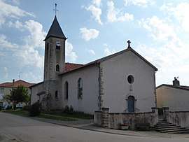 The church in Agincourt | ||
| ||
 Agincourt Location within Grand Est region  Agincourt | ||
| Coordinates: 48°44′01″N 6°14′17″E / 48.7336°N 6.2381°ECoordinates: 48°44′01″N 6°14′17″E / 48.7336°N 6.2381°E | ||
| Country | France | |
| Region | Grand Est | |
| Department | Meurthe-et-Moselle | |
| Arrondissement | Nancy | |
| Canton | Grand Couronné | |
| Intercommunality | Grand Couronné | |
| Government | ||
| • Mayor (2014-2020) | Denis Lapointe | |
| Area1 | 4.17 km2 (1.61 sq mi) | |
| Population (2014)2 | 441 | |
| • Density | 110/km2 (270/sq mi) | |
| Time zone | UTC+1 (CET) | |
| • Summer (DST) | UTC+2 (CEST) | |
| INSEE/Postal code | 54006 /54770 | |
| Elevation |
204–322 m (669–1,056 ft) (avg. 225 m or 738 ft) | |
|
1 French Land Register data, which excludes lakes, ponds, glaciers > 1 km2 (0.386 sq mi or 247 acres) and river estuaries. 2 Population without double counting: residents of multiple communes (e.g., students and military personnel) only counted once. | ||

Agincourt is a commune in the Meurthe-et-Moselle department in northeastern France.
Population
| Historical population | ||
|---|---|---|
| Year | Pop. | ±% |
| 1962 | 252 | — |
| 1968 | 276 | +9.5% |
| 1975 | 310 | +12.3% |
| 1982 | 358 | +15.5% |
| 1990 | 412 | +15.1% |
| 1999 | 399 | −3.2% |
| 2009 | 420 | +5.3% |
Inhabitants are called Agincourtois.
See also
- Communes of the Meurthe-et-Moselle department
- Commune of Azincourt, site of the Battle of Agincourt
- The Toronto neighbourhood of Agincourt, named for Azincourt but spelled as Agincourt
References
| Wikimedia Commons has media related to Agincourt (Meurthe-et-Moselle). |
This article is issued from
Wikipedia.
The text is licensed under Creative Commons - Attribution - Sharealike.
Additional terms may apply for the media files.