Xonville
| Xonville | ||
|---|---|---|
| Commune | ||
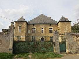 Chateau Xonville | ||
| ||
 Xonville Location within Grand Est region  Xonville | ||
| Coordinates: 49°03′21″N 5°50′58″E / 49.0558°N 5.8494°ECoordinates: 49°03′21″N 5°50′58″E / 49.0558°N 5.8494°E | ||
| Country | France | |
| Region | Grand Est | |
| Department | Meurthe-et-Moselle | |
| Arrondissement | Briey | |
| Canton | Jarny | |
| Intercommunality | Communauté de communes Mad et Moselle | |
| Government | ||
| • Mayor (2014-2020) | Jean-Marie Cuny | |
| Area1 | 7.27 km2 (2.81 sq mi) | |
| Population (2014)2 | 135 | |
| • Density | 19/km2 (48/sq mi) | |
| Time zone | UTC+1 (CET) | |
| • Summer (DST) | UTC+2 (CEST) | |
| INSEE/Postal code | 54599 /54800 | |
| Elevation |
213–251 m (699–823 ft) (avg. 220 m or 720 ft) | |
|
1 French Land Register data, which excludes lakes, ponds, glaciers > 1 km2 (0.386 sq mi or 247 acres) and river estuaries. 2 Population without double counting: residents of multiple communes (e.g., students and military personnel) only counted once. | ||

Xonville is a commune in the Meurthe-et-Moselle department in north-eastern France.
See also
| Wikimedia Commons has media related to Xonville. |
This article is issued from
Wikipedia.
The text is licensed under Creative Commons - Attribution - Sharealike.
Additional terms may apply for the media files.