Anderny
| Anderny | ||
|---|---|---|
| Commune | ||
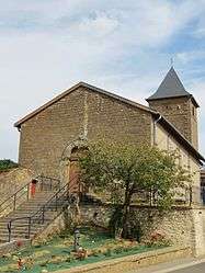 Parish church of Saint-Étienne Anderny | ||
| ||
 Anderny Location within Grand Est region  Anderny | ||
| Coordinates: 49°20′10″N 5°52′59″E / 49.3361°N 5.8831°ECoordinates: 49°20′10″N 5°52′59″E / 49.3361°N 5.8831°E | ||
| Country | France | |
| Region | Grand Est | |
| Department | Meurthe-et-Moselle | |
| Arrondissement | Briey | |
| Canton | Pays de Briey | |
| Intercommunality | Pays Audunois | |
| Government | ||
| • Mayor (2016-2020) | Patrick Bernard | |
| Area1 | 9.62 km2 (3.71 sq mi) | |
| Population (2014)2 | 257 | |
| • Density | 27/km2 (69/sq mi) | |
| Time zone | UTC+1 (CET) | |
| • Summer (DST) | UTC+2 (CEST) | |
| INSEE/Postal code | 54015 /54560 | |
| Elevation |
259–356 m (850–1,168 ft) (avg. 294 m or 965 ft) | |
|
1 French Land Register data, which excludes lakes, ponds, glaciers > 1 km2 (0.386 sq mi or 247 acres) and river estuaries. 2 Population without double counting: residents of multiple communes (e.g., students and military personnel) only counted once. | ||

Anderny is a commune in the Meurthe-et-Moselle department in northeastern France.
Population
| Historical population | ||
|---|---|---|
| Year | Pop. | ±% |
| 1962 | 446 | — |
| 1968 | 326 | −26.9% |
| 1975 | 288 | −11.7% |
| 1982 | 241 | −16.3% |
| 1990 | 199 | −17.4% |
| 1999 | 222 | +11.6% |
| 2009 | 303 | +36.5% |
See also
References
| Wikimedia Commons has media related to Anderny. |
This article is issued from
Wikipedia.
The text is licensed under Creative Commons - Attribution - Sharealike.
Additional terms may apply for the media files.