Jeandelaincourt
| Jeandelaincourt | |
|---|---|
| Commune | |
 | |
 Jeandelaincourt Location within Grand Est region  Jeandelaincourt | |
| Coordinates: 48°50′38″N 6°14′34″E / 48.8439°N 6.2428°ECoordinates: 48°50′38″N 6°14′34″E / 48.8439°N 6.2428°E | |
| Country | France |
| Region | Grand Est |
| Department | Meurthe-et-Moselle |
| Arrondissement | Nancy |
| Canton | Entre Seille et Meurthe |
| Intercommunality | Communauté de communes de Seille et Mauchère |
| Government | |
| • Mayor (2008–2014) | Philippe Joly |
| Area1 | 4.47 km2 (1.73 sq mi) |
| Population (2010)2 | 769 |
| • Density | 170/km2 (450/sq mi) |
| Time zone | UTC+1 (CET) |
| • Summer (DST) | UTC+2 (CEST) |
| INSEE/Postal code | 54276 /54114 |
| Elevation | 192–298 m (630–978 ft) |
|
1 French Land Register data, which excludes lakes, ponds, glaciers > 1 km2 (0.386 sq mi or 247 acres) and river estuaries. 2 Population without double counting: residents of multiple communes (e.g., students and military personnel) only counted once. | |
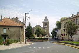
Jeandelaincourt is a commune in the Meurthe-et-Moselle department in north-eastern France.
Geography
- The village is situated at the foot of Mont Saint Jean (407m), 32 km North-east of Nancy.
- A natural path of discovery and a dashing pond located on the village.
History
- First tracks in 1090 under the name "Godelincourt", the village has a succession of several lords before finally Jeandelaincourt name in reference to the last lord named Jean.[1]
- Before installing the slate factory in 1893 the village was rural.
- Damage during the war 1914-1918
- Heavily damaged by the fighting in September 1944.
Demography
| Year | 1962 | 1968 | 1975 | 1982 | 1990 | 1999 | 2007 | 2010 |
|---|---|---|---|---|---|---|---|---|
| Population | 809 | 874 | 768 | 717 | 668 | 665 | 721 | 769 |
| From the year 1968 on: No double counting—residents of multiple communes (e.g. students and military personnel) are counted only once. | ||||||||
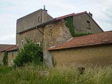
Monuments and sites
IMAG0294
P6230414
IMAG0295
P6230417
- Gallo-Roman discoveries on Mount Saint Jean.
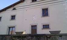
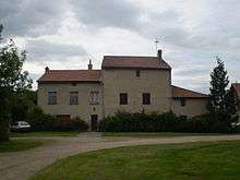
- Castles (or fortified houses) 14th/17th centuries. (see photos)
-Fortified-House "The Horgne" is an imposing building (now farm) which has a simple facade and a round tower on the back. It is located below the High Street at a place called "The Horgne".
-The second fortified-house is located high above the village, not far from the church. It has a facade with lattice windows and walled, above the front door, the date "1318" inscribed on the coat of arms of the lords of Jeandelaincourt. This one was also equipped with a round tower, now destroyed
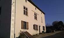
- Some nice houses 19th Louis Adt Avenue.
- Church 14th century (Romanesque tower).
- Jeandelaincourt is known beyond the borders for his slate factory closed a few years ago.[3]
See also
References
| Wikimedia Commons has media related to Jeandelaincourt. |
This article is issued from
Wikipedia.
The text is licensed under Creative Commons - Attribution - Sharealike.
Additional terms may apply for the media files.