Tiercelet
| Tiercelet | ||
|---|---|---|
| Commune | ||
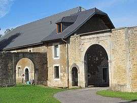 Castle entrance | ||
| ||
 Tiercelet Location within Grand Est region  Tiercelet | ||
| Coordinates: 49°27′45″N 5°53′06″E / 49.4625°N 5.885°ECoordinates: 49°27′45″N 5°53′06″E / 49.4625°N 5.885°E | ||
| Country | France | |
| Region | Grand Est | |
| Department | Meurthe-et-Moselle | |
| Arrondissement | Briey | |
| Canton | Villerupt | |
| Government | ||
| • Mayor (2008–2014) | Michel Brier | |
| Area1 | 7.68 km2 (2.97 sq mi) | |
| Population (1999)2 | 504 | |
| • Density | 66/km2 (170/sq mi) | |
| Time zone | UTC+1 (CET) | |
| • Summer (DST) | UTC+2 (CEST) | |
| INSEE/Postal code | 54525 /54190 | |
| Elevation |
360–432 m (1,181–1,417 ft) (avg. 409 m or 1,342 ft) | |
|
1 French Land Register data, which excludes lakes, ponds, glaciers > 1 km2 (0.386 sq mi or 247 acres) and river estuaries. 2 Population without double counting: residents of multiple communes (e.g., students and military personnel) only counted once. | ||

Tiercelet (Luxembourgish: Däitsch-Lahr and Lahr) is a commune in the Meurthe-et-Moselle department in north-eastern France.
See also
| Wikimedia Commons has media related to Tiercelet (Meurthe-et-Moselle). |
This article is issued from
Wikipedia.
The text is licensed under Creative Commons - Attribution - Sharealike.
Additional terms may apply for the media files.