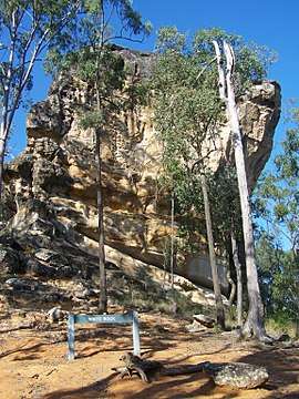
White Rock, Queensland (Ipswich)
| White Rock Ipswich, Queensland | |||||||||||||||
|---|---|---|---|---|---|---|---|---|---|---|---|---|---|---|---|
 White Rock Spring Mountain Conservation Reserve | |||||||||||||||
 White Rock | |||||||||||||||
| Coordinates | 27°41′42″S 152°50′56″E / 27.695°S 152.8488°ECoordinates: 27°41′42″S 152°50′56″E / 27.695°S 152.8488°E | ||||||||||||||
| Postcode(s) | 4306 | ||||||||||||||
| Area | 19.7 km2 (7.6 sq mi) | ||||||||||||||
| LGA(s) | City of Ipswich | ||||||||||||||
| State electorate(s) | Bundamba | ||||||||||||||
| Federal Division(s) | Blair | ||||||||||||||
| |||||||||||||||
White Rock is a locality in the City of Ipswich, Queensland, Australia.[1] The majority of land in White Rock remains covered in natural vegetation. In the far north west, the Centenary Motorway links Springfield with the Cunningham Highway to the west. The western half of White Rock lies with the catchment of the Bremer River and the eastern half within the Brisbane River catchment.
Conservation Park
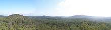
Bushland surrounding White Rock, 2010
The White Rock Conservation Park, now known as the White Rock – Spring Mountain Conservation Estate, is accessed by White Rock Drive from Redbank Plains. It is used for bushwalking and horse riding during the day. No camping or pets are permitted.[2]
References
- ↑ "White Rock - locality in City of Ipswich (entry 49527)". Queensland Place Names. Queensland Government. Retrieved 14 September 2017.
- ↑ "Parks and Reserves: White Rock – Spring Mountain Conservation Estate – Including Paperbark Flats Picnic Area". Ipswich City Council. Retrieved 19 September 2017.
This article is issued from
Wikipedia.
The text is licensed under Creative Commons - Attribution - Sharealike.
Additional terms may apply for the media files.