Eastern Heights, Queensland
| Eastern Heights Ipswich, Queensland | |||||||||||||||
|---|---|---|---|---|---|---|---|---|---|---|---|---|---|---|---|
 Eastern Heights | |||||||||||||||
| Coordinates | 27°37′33″S 152°46′28″E / 27.62583°S 152.77444°ECoordinates: 27°37′33″S 152°46′28″E / 27.62583°S 152.77444°E | ||||||||||||||
| Population | 3,709 (2016 census)[1] | ||||||||||||||
| • Density | 2,180/km2 (5,650/sq mi) | ||||||||||||||
| Postcode(s) | 4305 | ||||||||||||||
| Area | 1.7 km2 (0.7 sq mi) | ||||||||||||||
| Location | |||||||||||||||
| LGA(s) | City of Ipswich | ||||||||||||||
| State electorate(s) | Ipswich | ||||||||||||||
| Federal Division(s) | Blair | ||||||||||||||
| |||||||||||||||
Eastern Heights is a residential suburb in the City of Ipswich, Queensland, Australia.[2] At the 2016 Australian Census the suburb recorded a population of approximately 3,700.[1]
Geography
Eastern Heights is bordered to the west by Queens Park and Limestone Park.
History
The origin of the suburb name is from a high ridge on the eastern side of the Ipswich CBD.[2]
Transport
Eastern Heights is serviced by a regular bus service.
Education
To serve the growing settlement, the Newtown State School opened in 1882. In 1915 the old school buildings were put up for sale. One section found its way to Redbank Plains State School while the other became the property of W. Pysden a boot repairer in East Street, Ipswich. Many buildings in the Ipswich area have a similar history of migration.[3]
There are no schools currently in Eastern Heights, Silkstone Primary lie just to the east in Silkstone, while Ipswich Central Primary lie just to the west. Bremer State High School used to lie in the east as with Silkstone Primary, but has since moved further south-west of the suburb.
Parks and sports facilities
- Jim Donald Memorial Park (soccer)
- Hancock Park
- Scout Hall
Places of worship
- St Peters Anglican Church, Lloyd George St
- Our Lady of the Miraculous Medal Catholic Church (OLMM), Robertson Road
Heritage listings
Eastern Heights has a number of heritage-listed sites, including:
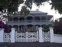
- 2A Robertson Road: Fairy Knoll[4]
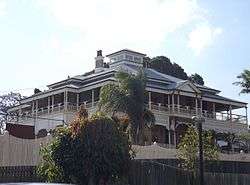
- 59 Whitehill Road: Garowie[5]
 Garowie 20/04/2015
References
- 1 2 Australian Bureau of Statistics (27 June 2017). "Eastern Heights (State Suburb)". 2016 Census QuickStats. Retrieved 29 March 2018.

- 1 2 "Eastern Heights - suburb (entry 45043)". Queensland Place Names. Queensland Government. Retrieved 21 June 2017.
- ↑ Council, Ipswich City. "Suburb and Place Names". www.ipswich.qld.gov.au. Retrieved 2018-04-20.
- ↑ "Fairy Knoll (entry 600600)". Queensland Heritage Register. Queensland Heritage Council. Retrieved 9 July 2013.
- ↑ "Garowie (entry 600599)". Queensland Heritage Register. Queensland Heritage Council. Retrieved 9 July 2013.
External links
| Wikimedia Commons has media related to Eastern Heights, Queensland. |