Ipswich (suburb), Queensland
| Ipswich Ipswich, Queensland | |||||||||||||||
|---|---|---|---|---|---|---|---|---|---|---|---|---|---|---|---|
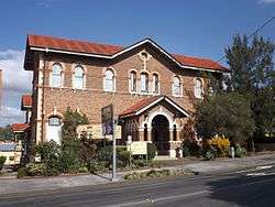
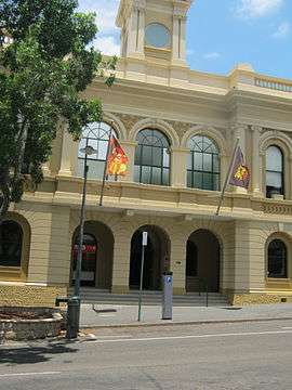 Ipswich Town Hall, 2012 | |||||||||||||||
| Population | 2,459 (2016)[1] | ||||||||||||||
| • Density | 585/km2 (1,516/sq mi) | ||||||||||||||
| Established | 1843 | ||||||||||||||
| Postcode(s) | 4305 | ||||||||||||||
| Elevation | 40 m (131 ft) | ||||||||||||||
| Area | 4.2 km2 (1.6 sq mi) | ||||||||||||||
| Location | 39 km (24 mi) SW of Brisbane | ||||||||||||||
| LGA(s) | City of Ipswich | ||||||||||||||
| State electorate(s) | Ipswich | ||||||||||||||
| Federal Division(s) | Blair, Oxley | ||||||||||||||
| |||||||||||||||
Coordinates: 27°37′23″S 152°45′36″E / 27.623°S 152.760°E
Ipswich is the innermost suburb of Ipswich, Queensland, Australia. The suburb situated on the Bremer River.
Geography
The suburb of Ipswich has a number of distinct areas. The Ipswich central business district is in the north with the Bremer River forming the northern boundary. Limestone Hill and its parklands are to the east (27°37′01″S 152°46′09″E / 27.61694°S 152.76917°E).[2][3] Denmark Hill with its exclusive residential area and conservation park is to the west (27°37′09″S 152°45′14″E / 27.61917°S 152.75389°E).[4][5] A mixture of health, educations and residential areas make up the south.[6]
Ipswich CBD
The Ipswich CBD is centred on Brisbane and Limestone Streets, and the Ipswich Mall, and includes major supermarkets and chain stores, specialties stores and the many government agencies. Most street parking is controlled by parking meters in business hours.
Heritage listings
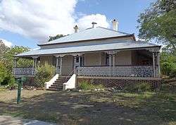
Ipswich has a number of heritage-listed sites, including:
- 5 Brisbane Street: Queensland Country Women's Association Girls' Hostel[7]
- 25 Brisbane Street: Ulster Hotel[8]
- 89 Brisbane Street: Queensland National Bank[9]
- 93 Brisbane Street: William Johnston's Shops[10]
- 116 Brisbane Street: Old Ipswich Town Hall[11]
- 116A Brisbane Street: former Bank of Australasia[12]
- 124 Brisbane Street: St Pauls Anglican Church[13]
- 169-175 Brisbane Street: Bostock Chambers[14]
- 188 Brisbane Street: Baptist Church[15]
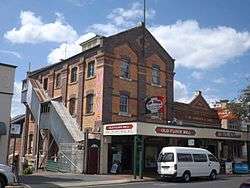
- 231 Brisbane Street: Flour Mill[16]
- 253 Brisbane Street: Hotel Metropole[17]
- 68 Chermside Road: St Michaels Nursing Home[18]
- 82 Chermside Road: Ipswich Girls' Grammar School Buildings[19]
- 82 Chermside Road: Lime Kiln Remains[20]
- 48 d'Arcy Doyle Place (formerly Nicholas Street): St Paul's Young Men's Club[21]
- Ellenborough Street: Ipswich Central Mission[22]
- Ellenborough Street: Railway Signal Cabin and Turntable[23]
- 45 East Street: Ipswich & West Moreton Building Society building[24]
- 59 East Street: Old Ipswich Courthouse[25]
- 86 East Street: Uniting Church Central Memorial Hall[26]
- 1 Ginn Street: Ginn Cottage[27]
- 14 Gray Street: Ipswich Club House[28]
- Limestone Street: Liberty Hall[29]
- 22 Limestone Street: St Stephen's Church[30]
- 88 Limestone Street: Ipswich Technical College[31]
- 103 Limestone Street: Penrhyn[32]
- 109 Limestone Street: Colthup's House[33]
- 7 Macalister Street: To-Me-Ree[34]
- Mary Street: St Marys Roman Catholic Church[35]
- Milford Street: Queens Park[36]
- 1A Milford Street: Claremont[37]
- 10A Milford Street: Walter Burley Griffin Incinerator[38]
- 11 Murphy Street: Brickstone[39]
- 63 Nicholas Street: Soldiers' Memorial Hall[40]
- 3 Parker Avenue: Ipswich Mental Hospital (Challinor Centre)[41]
- 21 Quarry Street: Central Congregational Church Manse[42]
- 30 Quarry Street: Toronto (formerly known as Devonshire Cottage)[43]
- 43 Quarry Street: Gooloowan[44]
- Rockton Street: Rockton[45]
- 20 Roderick Street: Keiraville[46]
- 66 Roderick Street: Ozanam House[47]
- Woodend Road: Ipswich Grammar School Buildings[48]
Transport

Local transport
There are three forms of public train transport servicing the Ipswich region.
- Queensland Rail City network offers regular services to and from Ipswich railway station to Brisbane, Brisbane Airport, the eastern suburbs, and western suburbs (as far as Rosewood).
- Westside Buslines is the prominent bus company in Ipswich, linking all sides of town to Ipswich CBD; Redbank; Springfield; or Forest Lake (in Brisbane).
- Southern Cross Citilink is a bus which operates between Ipswich and Indooroopilly via Riverlink, Karalee, Chuwar, Karana Downs, Anstead, and Kenmore.
- Queensland Rail buses offer direct daily services to Gatton, Helidon, Fernvale, Lowood, Coominya, Esk, and Toogoolawah.
- An Airport Express Bus operates from Ipswich to Brisbane Airport on a regular basis. Bookings are essential.
Ipswich also has direct access to the Ipswich Motorway (linking to Brisbane); the Cunningham Highway (linking to Warwick); the Warrego Highway (linking to Toowoomba); and the Centenary Highway (linking Springfield and the Ripley Valley to Brisbane).
Long distance transport
- The Westlander train pasts through Ipswich Station twice a week to Toowoomba and Charleville.
- Greyhound Australia (coaches) offer daily direct services to Toowoomba, Mount Isa, Charleville and Sydney from the Ipswich Transit Centre.
- Crisps Coaches offer daily direct services to and from Warwick, Queensland and Stanthorpe.
Education
- University of Southern Queensland, Ipswich Campus, formerly the Ipswich Campus of the University of Queensland and the Ipswich Mental Hospital (Challinor Centre)
- Ipswich Girls' Grammar School, established 1892
- West Moreton Anglican College, established 1994
- Ipswich Central Primary
- Ipswich Special School
Libraries
The Ipswich Council operates the Ipswich Central Library at 40 South Street.[49] It opened in 1994 and had a major refurbishment in 2017.[50]
Health
- Ipswich Hospital Chelmsford Avenue
- St Andrews Private Hospital, Roderick Street
Many GPs and specialists can be found in Brisbane and Limestone Street, and near both hospitals.
Parks and sports facilities
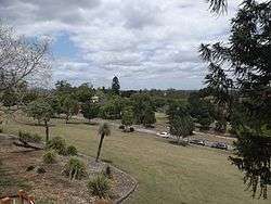
- Queens Park
- Limestone Park (AFL, running track, velodrome, netball)
- Sandy Gallop Golf Course
- BMX track
- Denmark Hill Conservation Park
- Ipswich Show Ground (including indoor sports centre)
Places of worship
- St Mary's Catholic Church, Elizabeth Street
- St Paul's Anglican Church, Brisbane Street
- Calvary Baptist Church, Chermside Street
- Uniting Church, Ellenborough Street
- Church of Jesus Christ of Latter Day Saints, cnr Hunter and Haig Streets
- The Salvation Army, South Street
- Jehovah's Witnesses, Salisbury Street
- St John's Lutheran Church, Roderick Street
- Centro Church, Pring Street
Demographics
In the 2016 Census the population of Ipswich is 2,459, 52.8% female and 47.2% male.[1] The median age of the Ipswich population is 41 years of age. Aboriginal and Torres Strait Islander people made up 6.1% of the population. 74.4% of people were born in Australia and 74.4% of people were born in Australia. The most common responses for religion were No Religion 32.1%, Catholic 19.3% and Anglican 14.3%.[1]
References
- 1 2 3 Australian Bureau of Statistics (27 June 2017). "Ipswich (State Suburb)". 2016 Census QuickStats. Retrieved 22 November 2017.

- ↑ "Limestone Hill - hill (entry 42502)". Queensland Place Names. Queensland Government. Retrieved 27 October 2015.
- ↑ "Limestone Hill - neighbourhood (entry 39008)". Queensland Place Names. Queensland Government. Retrieved 27 October 2015.
- ↑ "Denmark Hill - hill (entry 42501)". Queensland Place Names. Queensland Government. Retrieved 27 October 2015.
- ↑ "Denmark Hill - neighbourhood (entry 9747)". Queensland Place Names. Queensland Government. Retrieved 27 October 2015.
- ↑ "Queensland Globe". State of Queensland. Retrieved 25 October 2015.
- ↑ "Queensland Country Women's Association Girls' Hostel (entry 600558)". Queensland Heritage Register. Queensland Heritage Council. Retrieved 9 July 2013.
- ↑ "Ulster Hotel (entry 600564)". Queensland Heritage Register. Queensland Heritage Council. Retrieved 9 July 2013.
- ↑ "Queensland National Bank - Bank of Queensland (entry 600559)". Queensland Heritage Register. Queensland Heritage Council. Retrieved 9 July 2013.
- ↑ "Action Realty (entry 600560)". Queensland Heritage Register. Queensland Heritage Council. Retrieved 9 July 2013.
- ↑ "Old Town Hall (entry 600566)". Queensland Heritage Register. Queensland Heritage Council. Retrieved 9 July 2013.
- ↑ "Former Council Offices, Brisbane Street Ipswich (entry 600568)". Queensland Heritage Register. Queensland Heritage Council. Retrieved 9 July 2013.
- ↑ "St Pauls Anglican Church and Rectory (entry 600591)". Queensland Heritage Register. Queensland Heritage Council. Retrieved 9 July 2013.
- ↑ "Bostock Chambers (entry 600563)". Queensland Heritage Register. Queensland Heritage Council. Retrieved 9 July 2013.
- ↑ "Baptist Church and Memorial Gate (former), Ipswich (entry 602573)". Queensland Heritage Register. Queensland Heritage Council. Retrieved 9 July 2013.
- ↑ "Flour Mill (entry 600556)". Queensland Heritage Register. Queensland Heritage Council. Retrieved 9 July 2013.
- ↑ "Hotel Metropole (entry 600567)". Queensland Heritage Register. Queensland Heritage Council. Retrieved 9 July 2013.
- ↑ "St Michaels Nursing Home (entry 600573)". Queensland Heritage Register. Queensland Heritage Council. Retrieved 9 July 2013.
- ↑ "Ipswich Girls Grammar School (entry 600565)". Queensland Heritage Register. Queensland Heritage Council. Retrieved 9 July 2013.
- ↑ "Lime Kiln Remains (entry 600562)". Queensland Heritage Register. Queensland Heritage Council. Retrieved 9 July 2013.
- ↑ "St Paul's Young Men's Club - Art Gallery (entry 600584)". Queensland Heritage Register. Queensland Heritage Council. Retrieved 9 July 2013.
- ↑ "Ipswich Central Mission - Wesleyan Chapel (entry 600578)". Queensland Heritage Register. Queensland Heritage Council. Retrieved 9 July 2013.
- ↑ "Railway Signal Cabin and Turntable (entry 602464)". Queensland Heritage Register. Queensland Heritage Council. Retrieved 9 July 2013.
- ↑ "Ipswich & West Moreton Building Society (entry 600574)". Queensland Heritage Register. Queensland Heritage Council. Retrieved 9 July 2013.
- ↑ "Ipswich Court House (entry 600575)". Queensland Heritage Register. Queensland Heritage Council. Retrieved 9 July 2013.
- ↑ "Uniting Church Central Memorial Hall (entry 600576)". Queensland Heritage Register. Queensland Heritage Council. Retrieved 9 July 2013.
- ↑ "Ginn Cottage (entry 600579)". Queensland Heritage Register. Queensland Heritage Council. Retrieved 9 July 2013.
- ↑ "Ipswich Club House (entry 600581)". Queensland Heritage Register. Queensland Heritage Council. Retrieved 9 July 2013.
- ↑ "Liberty Hall - Mary Tregear Hostel (entry 600583)". Queensland Heritage Register. Queensland Heritage Council. Retrieved 9 July 2013.
- ↑ "St Stephen's Church & Hall (entry 600580)". Queensland Heritage Register. Queensland Heritage Council. Retrieved 9 July 2013.
- ↑ "Queen Victoria Silver Jubilee Memorial Technical College (entry 600586)". Queensland Heritage Register. Queensland Heritage Council. Retrieved 9 July 2013.
- ↑ "Residence, 103 Limestone St (1879) (entry 600585)". Queensland Heritage Register. Queensland Heritage Council. Retrieved 9 July 2013.
- ↑ "Residence, 109 Limestone Street (c1880) (entry 600582)". Queensland Heritage Register. Queensland Heritage Council. Retrieved 9 July 2013.
- ↑ "To-Me-Ree (entry 600588)". Queensland Heritage Register. Queensland Heritage Council. Retrieved 9 July 2013.
- ↑ "St Marys Roman Catholic Church Precinct (entry 600577)". Queensland Heritage Register. Queensland Heritage Council. Retrieved 9 July 2013.
- ↑ "Queen's Park (entry 602356)". Queensland Heritage Register. Queensland Heritage Council. Retrieved 9 July 2013.
- ↑ "Claremont (entry 600589)". Queensland Heritage Register. Queensland Heritage Council. Retrieved 9 July 2013.
- ↑ "Walter Burley Griffin Incinerator (former) (entry 600596)". Queensland Heritage Register. Queensland Heritage Council. Retrieved 9 July 2013.
- ↑ "Brickstone (entry 600590)". Queensland Heritage Register. Queensland Heritage Council. Retrieved 9 July 2013.
- ↑ "Soldiers' Memorial Hall, Ipswich (entry 600592)". Queensland Heritage Register. Queensland Heritage Council. Retrieved 9 July 2013.
- ↑ "Challinor Centre (entry 601821)". Queensland Heritage Register. Queensland Heritage Council. Retrieved 9 July 2013.
- ↑ "Central Congregational Church Manse (entry 600594)". Queensland Heritage Register. Queensland Heritage Council. Retrieved 9 July 2013.
- ↑ "Toronto (entry 600595)". Queensland Heritage Register. Queensland Heritage Council. Retrieved 9 July 2013.
- ↑ "Gooloowan (entry 600593)". Queensland Heritage Register. Queensland Heritage Council. Retrieved 9 July 2013.
- ↑ "Rockton (entry 600552)". Queensland Heritage Register. Queensland Heritage Council. Retrieved 9 July 2013.
- ↑ "Keiraville (entry 600597)". Queensland Heritage Register. Queensland Heritage Council. Retrieved 9 July 2013.
- ↑ "Ozanam House (entry 600598)". Queensland Heritage Register. Queensland Heritage Council. Retrieved 9 July 2013.
- ↑ "Ipswich Grammar School (entry 600601)". Queensland Heritage Register. Queensland Heritage Council. Retrieved 9 July 2013.
- ↑ "Ipswich Central Library". Public Libraries Connect. State Library of Queensland. 29 August 2017. Retrieved 24 January 2018.
- ↑ "Public Libraries Statistical Bulletin 2016-17" (PDF). Public Libraries Connect. State Library of Queensland. November 2017. p. 13. Archived (PDF) from the original on 30 January 2018. Retrieved 30 January 2018.
External links
| Wikimedia Commons has media related to Ipswich, Queensland. |
- Blythe, Andrew. A Retailing History of the Ipswich Central Business District (CBD) from the mid-1970s to 2003 (PDF). Ipswich City Council. Archived from the original (PDF) on 31 July 2017.