Newtown, Queensland (Ipswich)
| Newtown Ipswich, Queensland | |||||||||||||||
|---|---|---|---|---|---|---|---|---|---|---|---|---|---|---|---|
 Rockton Street, 2015 | |||||||||||||||
 Newtown | |||||||||||||||
| Coordinates | 27°37′S 152°47′E / 27.617°S 152.783°ECoordinates: 27°37′S 152°47′E / 27.617°S 152.783°E | ||||||||||||||
| Population | 1,615 (2016 census)[1] | ||||||||||||||
| Postcode(s) | 4305 | ||||||||||||||
| Location | |||||||||||||||
| LGA(s) | City of Ipswich | ||||||||||||||
| State electorate(s) | Ipswich | ||||||||||||||
| Federal Division(s) | Blair | ||||||||||||||
| |||||||||||||||
Newtown is a small residential suburb of Ipswich, Queensland, Australia. It is bordered by Queens Park to the west, to the north by Brisbane Road, the city's main arterial link to the Ipswich Motorway. At the 2016 Australian Census, the suburb recorded a population of 1,615.[1]
A small set of shops lies on the five-ways intersection where Brisbane Road, Queen Victoria Parade, Glebe Road and Chermside Road meet.
Transport
Newtown is serviced by East Ipswich railway station, which provides access to regular Queensland Rail City network services to Brisbane, Ipswich and Rosewood via Ipswich.
Heritage listings
St Michaels Nursing Home, 2015
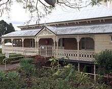
Newtown contains a number of heritage-listed sites including Rockton, a house at 4 Rockton Street and St Michaels Nursing Home at 68 Chermside Street.
Parks and Sports Facilities
- Spring Garden Park
- Newtown Park
References
- 1 2 Australian Bureau of Statistics (27 June 2017). "Newtown (Ipswich - Qld) (State Suburb)". 2016 Census QuickStats. Retrieved 29 March 2018.

External links
This article is issued from
Wikipedia.
The text is licensed under Creative Commons - Attribution - Sharealike.
Additional terms may apply for the media files.