Calvert, Queensland
| Calvert Ipswich, Queensland | |||||||||||||||
|---|---|---|---|---|---|---|---|---|---|---|---|---|---|---|---|
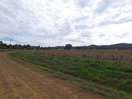 Houses and paddocks along Waters Road, 2015 | |||||||||||||||
| Population | 313 (2016)[1] | ||||||||||||||
| Postcode(s) | 4340 | ||||||||||||||
| LGA(s) | City of Ipswich | ||||||||||||||
| State electorate(s) | |||||||||||||||
| Federal Division(s) | Blair | ||||||||||||||
| |||||||||||||||
Calvert is a town and locality in the City of Ipswich, Queensland, Australia.[2][3] At the 2016 Australian Census the suburb recorded a population of 313.[1]
History
In 1865, Calvert residents petitioned for a rail station which opened the following year.[4]
Geography
The Main Line railway passes through Calvert as does Western Creek, a tributary of the Bremer River. A 2014 flood mapping study of the Western Creek catchment has provided more reliable flood information to residents and landowners.[5] In the northern extents elevations rise to 340 metres above sea level around Mount Grandchester No. 2. which is part of the Little Liverpool Range. The landscape in the southern parts of Calvert is mostly used for agriculture.
References
- 1 2 Australian Bureau of Statistics (27 June 2017). "Calvert (State Suburb)". 2016 Census QuickStats. Retrieved 26 September 2017.

- ↑ "Calvert - town (entry 48147)". Queensland Place Names. Queensland Government. Retrieved 28 June 2017.
- ↑ "Calvert - locality (entry 45093)". Queensland Place Names. Queensland Government. Retrieved 28 June 2017.
- ↑ "Suburb and Place Names". Ipswich City Council. Retrieved 20 March 2018.
- ↑ Brian Bennion (27 November 2014). "New flood mapping study of Grandchester and Calvert". The Queensland Times. Retrieved 3 July 2015.
External links
Coordinates: 27°40′S 152°30′E / 27.667°S 152.500°E