Kollapur
| Kollapur | |
|---|---|
| Town | |
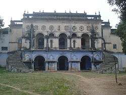 Kollapur Palace | |
 Kollapur Location in Telangana, India  Kollapur Kollapur (India) | |
| Coordinates: 16°10′59″N 78°20′26″E / 16.18306°N 78.34056°ECoordinates: 16°10′59″N 78°20′26″E / 16.18306°N 78.34056°E | |
| Country | India |
| State | Telangana |
| District | Nagarkurnool |
| Population | |
| • Total | 44,186 |
| Languages | |
| • Official | Telugu |
| Time zone | UTC+5:30 (IST) |
| PIN | 509102 |
| Telephone code | 08501 |
| Vehicle registration | TS 06 |
| Nearest city | Hyderabad, Kurnool,Gadwal |
| Literacy | 54% |
| Lok Sabha constituency | Nagarkurnool |
| Vidhan Sabha constituency | Kollapur |
| Website |
telangana |
Kollapur[1] region is an area spanning the Nallamala Forest area on the banks of the river Krishna in the Nagarkurnool district, in the state of Telangana India. The Someshwara, Sangameshwara, and Malleshwara temples are in this region, with traces of architectural treasures from the 2nd century BC. Hundreds of ancient temples are visible in the area, mainly built over 1,500 years ago. Due to similar broad roads and surrounding tree plantations, people used to refer to Kollapur as Telangana Mysore (a reference to the larger city of Mysore).
Constituency
There are five mandals or governing districts, namely Kodair, Kollapur, Pangal, Peddakothapally, and veepanagandla. The population of 246,249 is distributed among 116 villages.
Notable people
Jupally Krishna Rao, a Member of the Legislative Assembly in the Telangana Legislative Assembly, was born in Pedda Dagada, a village in the Kollapur region.
Dr V Ramgopal Rao, Director, IIT Delhi hails from this place
References
| Wikimedia Commons has media related to Kollapur. |
- ↑ "Archived copy" (PDF). Archived from the original (PDF) on 2014-12-19. Retrieved 2016-01-23.