Gadwal
| Gadwal | |
|---|---|
| City | |
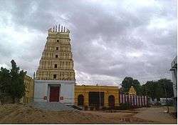 Chennakeshava swamy temple in Gadwal Fort | |
 Gadwal Location in Telangana, India  Gadwal Gadwal (India) | |
| Coordinates: 16°14′N 77°48′E / 16.23°N 77.8°ECoordinates: 16°14′N 77°48′E / 16.23°N 77.8°E | |
| Country | India |
| State | Telangana |
| Region | Deccan |
| District | Jogulamba Gadwal |
| Government | |
| • Type | Gadwal municipal council |
| • Body | congress |
| • MLA | D.K Aruna(INC) |
| • MP | AP Jithendar Reddy(TRS) |
| • Collector & District Magistrate | Rajat kumar saini IAS |
| • District Superintendent of Police | Rema Rajeshwari IPS |
| Area | |
| • Total | 33.46 km2 (12.92 sq mi) |
| Area rank | 1st in erstwhile district |
| Elevation[1] | 324 m (1,063 ft) |
| Population (2011)[2] | |
| • Total | 96,877[3] |
| Languages | |
| • Official | Telugu |
| Time zone | UTC+5.30 (IST) |
| PIN | 509125 |
| Vehicle registration | TS-33 |
| Website |
telangana |
Gadwal is a city and the district Headquarter of Jogulamba Gadwal district in the Indian state of Telangana.It is located 188 km (117 mi) from the state capital of Hyderabad and is a state assembly constituency. Gadwal historically served as the capital of Gadwal Samsthanam, a vassal of the Nizam of Hyderabad. Gadwal was previously part of the Raichur region of Hyderabad-Karnataka.
Gadwal Fort is an imposing structure around which the old city sprawls. The fort houses several old temples, the most important of which is Sri Chennakesava Swamy. Another well-known temple, Jammulamma, is located west to the town.
One of Gadwal's most-notable landmarks is the large dam, currently under construction, known as the Priyadarshini Jurala Project. It has almost 62 gates, and its generation capacity is 234 MW.[4]
Geography
Gadwal has an average elevation of 325 metres (1,066 ft). Gadwal's infrastructure includes a railway junction, river, government-owned land, a sub-collector office, national highway connectivity and brand image in the country.
History

According to The Imperial Gazetteer of India, was once part of Raichur district (though it is now in Mahabubnagar district). It was once ruled by Somashekar Ananda Reddy, affectionately called "Somanadri", who came from Pudur village. Gadwal developed around a fort built by the Gadwal ruler Somanadri, Gadwal Samsthanam, which was a vassal of the Nizam of Hyderabad. It was protected by Mallichetti vamshiyulu. The Nagi Reddy, known today as Nagappa, was an Ayngarashakulu of Gadwal Samsthanam (Raja Somanadri was a minor). He died in a war with Sultans. Nagappa was succeeded by Narsappa as Gadwal Samsthanam Ayngarashakulu, but had to leave the palace.[5]
Demographics
The Gadwal Samsthanam had a population of 968,491 in 1901, consisting of Gadwala town and 214 villages covering an area of 2,240 square kilometres (864 sq mi).
As of 2001,[6] Gadwala had a population of 53,560. Males constituted 51% of the population and females 49%. 13% of the population was under 6 years of age.
Gadwal Saree
Gadwala is known for its handloom Jari chiralu (Gadwala sarees). It was registered as one of the geographical indication from Telangana by Geographical Indications of Goods (Registration and Protection) Act, 1999.[7][8] They are most notable for the Zari on the saris. The sari consists of a cotton body with a silk pallu which called Sico saris. The weave is so light that the saree can be packed in a matchbox.[9] For Lord Venkateshwara Tirumala Tirupati Devasthanam (TTD) Bramhotsavam starts with Gadwala-weaved Pattu Vastralu every year.
Transport


Rail
Gadwal has a rail junction connecting to other towns and cities, with more than 40 trains passing through daily. The railway station is on Secunderabad Kurnool line. Gadwal became connected by rail to Raichur, Karnataka, after commissioning of the new line on October 12. Gadwal railway station is planned to become a four-line connecting junction with the addition of a Gadwal-Macherla line. The Railway Department is requiring sufficient land to be used for new railway projects.
Road
Gadwal is located 15 kilometres (9.3 mi) from National Highway 44 (formerly NH-7). A new national highway (Kothakota–Mantralayam) starts from Kothakota then reaches Gadwal, Ieeja, Gudur and Mantralayam. The newly sanctioned Yerravally–Raichur National highway also passes through Gadwal.
Telangana State Road Transport Corporation (TSRTC) runs bus services from Gadwal to major towns and villages.
Solar energy
With the Jurala Project, one of the most prestigious dams in India, 11 km (6.8 mi) away, the town has implemented solar energy for production of electricity.
References
| Wikimedia Commons has media related to Gadwal. |
- ↑ "Elevation for Pedakurapadu". Veloroutes. Retrieved 12 August 2014.
- ↑ "Census 2011". The Registrar General & Census Commissioner, India. Retrieved 25 July 2014.
- ↑ "Cities, Towns and Outgrowth Wards". Citypopulation.de. Retrieved 19 September 2015.
- ↑ "PRIYADARSHINI JURALA PROJECT". krmb.cgg.gov.in. Retrieved 2017-09-11.
- ↑ Gadwal Samthanam in Imperial Gazetteer
- ↑ "Census of India 2001: Data from the 2001 Census, including cities, villages and towns (Provisional)". Census Commission of India. Archived from the original on 2004-06-16. Retrieved 2008-11-01.
- ↑ "Geographical Indication". The Hans India. 23 January 2016. Retrieved 27 January 2016.
- ↑ "State Wise Registration Details of G.I Applications" (PDF). Geographical Indication Registry. p. 5. Archived from the original (PDF) on 1 February 2016. Retrieved 28 January 2016.
- ↑ "Gorgeous Gadwal". Deccan Herald. Retrieved 28 January 2016.