Yadagirigutta
| Yadagirigutta యాదగిరిగుట్ట Yadadri | |
|---|---|
| Temple City | |
 Yadagirigutta Temple | |
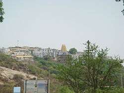
 Yadagirigutta Location in Telangana, India  Yadagirigutta Yadagirigutta (India) | |
| Coordinates: 17°35′11″N 78°56′46″E / 17.58639°N 78.94611°ECoordinates: 17°35′11″N 78°56′46″E / 17.58639°N 78.94611°E | |
| Country | India |
| State | Telangana |
| District | Bhuvanagiri |
| Area[1] | |
| • Total | 12.74 km2 (4.92 sq mi) |
| Population (2011)[1] | |
| • Total | 15,232 |
| • Density | 1,200/km2 (3,100/sq mi) |
| Languages | |
| • Official | Telugu |
| Time zone | UTC+5:30 (IST) |
| Vehicle registration | TS |
| Website |
telangana |
Yadagirigutta is a census town in Yadadri Bhuvanagiri district of the Indian state of Telangana. Yadagirigutta mandal is comes under Aler Constituency and Bhongir division[1]. It is renowned for Yadagirigutta Narasimha Temple[1][2].
Demographics
As of 2001 India census,[3] Yadagirigutta had a population of 13,267. Males constitute 50% of the population and females 50%. Yadagirigutta has an average literacy rate of 61%, less than the national average of 74.04%: male literacy is 71%, and female literacy is 52%. In Yadagirigutta, 13% of the population is under 6 years of age.
Transport
Yadagirigutta is about 60 km from Hyderabad and is well connected by Rail and Road. The nearest Cities are Aler and Bhongir and nearest railway station is Raigiri.
References
- 1 2 3 4 "District Census Handbook - Nalgonda" (PDF). Census of India. p. 13,164. Retrieved 8 February 2016.
- ↑ "Yadadri Bhuvanagiri District Profile" (PDF). trac.telangana.gov.in. Retrieved 24 June 2017.
- ↑ "Census of India 2001: Data from the 2001 Census, including cities, villages and towns (Provisional)". Census Commission of India. Archived from the original on 2004-06-16. Retrieved 2008-11-01.
This article is issued from
Wikipedia.
The text is licensed under Creative Commons - Attribution - Sharealike.
Additional terms may apply for the media files.