Trégomeur
| Trégomeur Tregonveur | ||
|---|---|---|
| Commune | ||
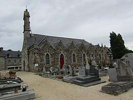 The church of Saint-Gildas, in Trégomeur | ||
| ||
 Trégomeur Location within Brittany region  Trégomeur | ||
| Coordinates: 48°33′59″N 2°52′50″W / 48.5664°N 2.8806°WCoordinates: 48°33′59″N 2°52′50″W / 48.5664°N 2.8806°W | ||
| Country | France | |
| Region | Brittany | |
| Department | Côtes-d'Armor | |
| Arrondissement | Guingamp | |
| Canton | Plélo | |
| Intercommunality | Pays de Châtelaudren–Plouagat | |
| Government | ||
| • Mayor (2014–2020) | Denis Manac'h | |
| Area1 | 10.37 km2 (4.00 sq mi) | |
| Population (2008)2 | 896 | |
| • Density | 86/km2 (220/sq mi) | |
| Time zone | UTC+1 (CET) | |
| • Summer (DST) | UTC+2 (CEST) | |
| INSEE/Postal code | 22356 /22590 | |
| Elevation | 20–123 m (66–404 ft) | |
|
1 French Land Register data, which excludes lakes, ponds, glaciers > 1 km2 (0.386 sq mi or 247 acres) and river estuaries. 2 Population without double counting: residents of multiple communes (e.g., students and military personnel) only counted once. | ||
.svg.png)
Trégomeur (Breton: Tregonveur) is a commune in the Côtes-d'Armor department of Brittany in northwestern France.
Population
| Historical population | ||
|---|---|---|
| Year | Pop. | ±% |
| 1962 | 559 | — |
| 1968 | 595 | +6.4% |
| 1975 | 610 | +2.5% |
| 1982 | 689 | +13.0% |
| 1990 | 682 | −1.0% |
| 1999 | 729 | +6.9% |
| 2008 | 896 | +22.9% |
Inhabitants of Trégomeur are called trégomeurois in French.
See also
References
External links
| Wikimedia Commons has media related to Trégomeur. |
- French Ministry of Culture list for Trégomeur (in French)
This article is issued from
Wikipedia.
The text is licensed under Creative Commons - Attribution - Sharealike.
Additional terms may apply for the media files.